Difference between revisions of "2017-04-02 -37 145"
imported>Thunk (An expedition message sent via Geohash Droid for Android.) |
m (More specific location) |
||
| (20 intermediate revisions by 4 users not shown) | |||
| Line 20: | Line 20: | ||
== Location == | == Location == | ||
<!-- where you've surveyed the hash to be --> | <!-- where you've surveyed the hash to be --> | ||
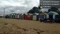
| + | Right outfield of Moorabbin Baseball Club field, Victoria, Australia | ||
== Participants == | == Participants == | ||
<!-- who attended: If you link to your wiki user name in this section, your expedition will be picked up by the various statistics generated for geohashing. You may use three tildes ~ as a shortcut to automatically insert the user signature of the account you are editing with. | <!-- who attended: If you link to your wiki user name in this section, your expedition will be picked up by the various statistics generated for geohashing. You may use three tildes ~ as a shortcut to automatically insert the user signature of the account you are editing with. | ||
--> | --> | ||
| − | + | *[[User:Thunk|Thunk]] ([[User talk:Thunk|talk]])<br/> | |
| − | + | *[[User:Felix Dance|Felix Dance]] ([[User talk:Felix Dance|talk]])<br/> | |
| − | < | ||
== Expedition == | == Expedition == | ||
<!-- how it all turned out. your narrative goes here. --> | <!-- how it all turned out. your narrative goes here. --> | ||
| + | === thunk === | ||
| + | Well, it's best summarized below. Also refer to the images section and tracklog. | ||
| + | |||
| + | *Pre-Opening Day hash on a baseball field. It'll be walk till you drop as I procrastinate on Sunday with a slow expedition. -- [[User:Thunk|Thunk]] ([[User talk:Thunk|talk]]) 09:34, 1 April 2017 (GMT+00:00) | ||
| + | |||
| + | *Good morning everyone. I'm off on this rather long walk. Let's see how long it can be. -- [[User:Thunk|Thunk]] ([[User talk:Thunk|talk]]) [http://www.openstreetmap.org/?lat=-37.91081460&lon=145.13563870&zoom=16&layers=B000FTF @-37.9108,145.1356] 22:02, 1 April 2017 (GMT+00:00) | ||
| + | |||
| + | *Time for the traditional Australian 'brekky'. It's not just a matter of the local customs but me needing to actually eat. -- [[User:Thunk|Thunk]] ([[User talk:Thunk|talk]]) [http://www.openstreetmap.org/?lat=-37.92553460&lon=145.11966180&zoom=16&layers=B000FTF @-37.9255,145.1197] 22:33, 1 April 2017 (GMT+00:00) | ||
| + | |||
| + | *Ow...Ow...Ow... | ||
| + | 34 km is quite enough for one day. -- [[User:Thunk|Thunk]] ([[User talk:Thunk|talk]]) [http://www.openstreetmap.org/?lat=-37.81282920&lon=144.96759060&zoom=16&layers=B000FTF @-37.8128,144.9676] 04:49, 2 April 2017 (GMT+00:00) | ||
| + | |||
| + | *It turns out that after I wrote that, I started feeling restless again. So on another whim, I started walking the 17 km from South Yarra station to my temporary hideaway. The first 5 km were relatively all right, but exhaustion soon set in, and I was at my limits by the time I completed my journey. The total distance on foot is currently unclear due to GPS jitters but is likely greater than 50 km. | ||
| + | |||
| + | And considering how sore I was for two days afterwards, it probably wasn't worth it. Though proper shoe choice left me with only one large blister on my right foot (and only a very small one on the left foot). | ||
| + | |||
| + | ===Felix Dance=== | ||
| + | |||
| + | *Hampton geohash success! -- [[User:Felix Dance|Felix Dance]] ([[User talk:Felix Dance|talk]]) [http://www.openstreetmap.org/?lat=-37.94071990&lon=145.02633930&zoom=16&layers=B000FTF @-37.9407,145.0263] 12:45, 2 April 2017 (GMT+10:00) | ||
| + | Some explanation: I was out in Fairfield after riding in the Mike Hall memorial ride along the Yarra - a tribute to Indian Pacific Wheel Race competitor and car-crash fatality victim Mike Hall - when I discovered the hash. I left the Abbotsford Convent cafe and headed south towards Hampton along Church/Chapel Streets, picking up an Astor calendar along the way (heavy Melbourne referencing). | ||
| + | |||
| + | After a fair ride along the Nepean Highway, I turned off and arrived at the park nestled between Hampton East and Moorabin. The sun was sunny so I took a nap on the grass - a hashnap. But soon I was back on the bike and riding directly north into the tailwind, all the way up Burke Rd, a tour of the Eastern suburbs, to a first birthday party in Ivanhoe. I'll work out my total distance in a bit, but it must be about 60 Kms, or about 90 for the day. | ||
== Tracklog == | == Tracklog == | ||
| Line 39: | Line 61: | ||
--> | --> | ||
<gallery perrow="5"> | <gallery perrow="5"> | ||
| + | |||
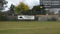
| + | Image:2017-04-02_-37_145_thunk_1491091334334.jpg|So that's where they play this footy... [http://www.openstreetmap.org/?lat=-37.93639560&lon=145.04262620&zoom=16&layers=B000FTF @-37.9364,145.0426] | ||
| + | |||
| + | Image:2017-04-02_-37_145_thunk_1491092506624.jpg|And here we are. [http://www.openstreetmap.org/?lat=-37.94069940&lon=145.02633420&zoom=16&layers=B000FTF @-37.9407,145.0263] | ||
| + | |||
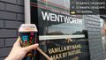
| + | Image:2017-04-02_-37_145_thunk_1491093298632.jpg|Squishy time! | ||
| + | It was slightly drizzling as I arrived so it might be 7 stars even. [http://www.openstreetmap.org/?lat=-37.94660350&lon=145.02248790&zoom=16&layers=B000FTF @-37.9466,145.0225] | ||
| + | |||
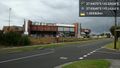
| + | Image:2017-04-02_-37_145_thunk_1491096714855.jpg|Why stop at the hash? | ||
| + | But it's time for a quick rest anyway. [http://www.openstreetmap.org/?lat=-37.91730270&lon=144.98643650&zoom=16&layers=B000FTF @-37.9173,144.9864] | ||
| + | |||
| + | Image:2017-04-02_-37_145_thunk_1491100341382.jpg|And I've reached St. Kilda. Which will give out first--my legs or my phone battery? [http://www.openstreetmap.org/?lat=-37.86925950&lon=144.97565030&zoom=16&layers=B000FTF @-37.8693,144.9757] | ||
| + | |||
| + | Image:2017-04-02_-37_145_Felix Dance_1491101187377.jpg|GPS proof - 0.66m away [http://www.openstreetmap.org/?lat=-37.94071410&lon=145.02632110&zoom=16&layers=B000FTF @-37.9407,145.0263] | ||
| + | |||
| + | Image:2017-04-02_-37_145_Felix Dance_1491101206819.jpg|Me with bike at the hash [http://www.openstreetmap.org/?lat=-37.94072570&lon=145.02631460&zoom=16&layers=B000FTF @-37.9407,145.0263] | ||
</gallery> | </gallery> | ||
| Line 44: | Line 82: | ||
{{#vardefine:ribbonwidth|800px}} | {{#vardefine:ribbonwidth|800px}} | ||
<!-- Add any achievement ribbons you earned below, or remove this section --> | <!-- Add any achievement ribbons you earned below, or remove this section --> | ||
| + | {{Walk geohash | ||
| + | | latitude = -37 | ||
| + | | longitude = 145 | ||
| + | | date = 2017-04-02 | ||
| + | | name = [[User:thunk|thunk]] | ||
| + | | distance = 51km | ||
| + | }} | ||
| + | {{GeoSquishy 7Star | latitude = -37 | longitude = 145 | date = 2017-04-02 | name = thunk }} | ||
| + | {{Minesweeper geohash | graticule = Melbourne East, Australia| ranknumber = 2 | w = true | s = true | name = thunk }} | ||
<!-- =============== USEFUL CATEGORIES FOLLOW ================ | <!-- =============== USEFUL CATEGORIES FOLLOW ================ | ||
Delete the next line ONLY if you have chosen the appropriate categories below. If you are unsure, don't worry. People will read your report and help you with the classification. --> | Delete the next line ONLY if you have chosen the appropriate categories below. If you are unsure, don't worry. People will read your report and help you with the classification. --> | ||
| − | |||
| − | |||
<!-- ==REQUEST FOR TWITTER BOT== Please leave either the New report or the Expedition planning category in as long as you work on it. This helps the twitter bot a lot with announcing the right outcome at the right moment. --> | <!-- ==REQUEST FOR TWITTER BOT== Please leave either the New report or the Expedition planning category in as long as you work on it. This helps the twitter bot a lot with announcing the right outcome at the right moment. --> | ||
| − | |||
| − | |||
| − | |||
| − | |||
<!-- If all those plans are never acted upon, change [[Category:Expedition planning]] to [[Category:Not reached - Did not attempt]]. --> | <!-- If all those plans are never acted upon, change [[Category:Expedition planning]] to [[Category:Not reached - Did not attempt]]. --> | ||
| − | + | ||
[[Category:Expeditions]] | [[Category:Expeditions]] | ||
| − | |||
[[Category:Expeditions with photos]] | [[Category:Expeditions with photos]] | ||
| − | |||
| − | |||
| − | |||
| − | |||
| − | |||
[[Category:Coordinates reached]] | [[Category:Coordinates reached]] | ||
| − | + | {{location|AU|VIC|BS}} | |
| − | |||
| − | |||
| − | |||
| − | |||
| − | |||
| − | |||
| − | |||
| − | |||
| − | |||
| − | |||
| − | |||
| − | |||
| − | |||
| − | |||
| − | |||
| − | |||
| − | |||
Latest revision as of 12:52, 1 August 2020
| Sun 2 Apr 2017 in -37,145: -37.9407021, 145.0263431 geohashing.info google osm bing/os kml crox |
Location
Right outfield of Moorabbin Baseball Club field, Victoria, Australia
Participants
- Thunk (talk)
- Felix Dance (talk)
Expedition
thunk
Well, it's best summarized below. Also refer to the images section and tracklog.
- Pre-Opening Day hash on a baseball field. It'll be walk till you drop as I procrastinate on Sunday with a slow expedition. -- Thunk (talk) 09:34, 1 April 2017 (GMT+00:00)
- Good morning everyone. I'm off on this rather long walk. Let's see how long it can be. -- Thunk (talk) @-37.9108,145.1356 22:02, 1 April 2017 (GMT+00:00)
- Time for the traditional Australian 'brekky'. It's not just a matter of the local customs but me needing to actually eat. -- Thunk (talk) @-37.9255,145.1197 22:33, 1 April 2017 (GMT+00:00)
- Ow...Ow...Ow...
34 km is quite enough for one day. -- Thunk (talk) @-37.8128,144.9676 04:49, 2 April 2017 (GMT+00:00)
- It turns out that after I wrote that, I started feeling restless again. So on another whim, I started walking the 17 km from South Yarra station to my temporary hideaway. The first 5 km were relatively all right, but exhaustion soon set in, and I was at my limits by the time I completed my journey. The total distance on foot is currently unclear due to GPS jitters but is likely greater than 50 km.
And considering how sore I was for two days afterwards, it probably wasn't worth it. Though proper shoe choice left me with only one large blister on my right foot (and only a very small one on the left foot).
Felix Dance
- Hampton geohash success! -- Felix Dance (talk) @-37.9407,145.0263 12:45, 2 April 2017 (GMT+10:00)
Some explanation: I was out in Fairfield after riding in the Mike Hall memorial ride along the Yarra - a tribute to Indian Pacific Wheel Race competitor and car-crash fatality victim Mike Hall - when I discovered the hash. I left the Abbotsford Convent cafe and headed south towards Hampton along Church/Chapel Streets, picking up an Astor calendar along the way (heavy Melbourne referencing).
After a fair ride along the Nepean Highway, I turned off and arrived at the park nestled between Hampton East and Moorabin. The sun was sunny so I took a nap on the grass - a hashnap. But soon I was back on the bike and riding directly north into the tailwind, all the way up Burke Rd, a tour of the Eastern suburbs, to a first birthday party in Ivanhoe. I'll work out my total distance in a bit, but it must be about 60 Kms, or about 90 for the day.
Tracklog
Photos
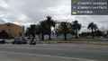
So that's where they play this footy... @-37.9364,145.0426
And here we are. @-37.9407,145.0263
Squishy time!
Why stop at the hash?
And I've reached St. Kilda. Which will give out first--my legs or my phone battery? @-37.8693,144.9757
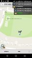
GPS proof - 0.66m away @-37.9407,145.0263
- Error creating thumbnail: Unable to save thumbnail to destination
Me with bike at the hash @-37.9407,145.0263


Achievements
thunk earned the Walk geohash Achievement
|
thunk earned the 7 Star GeoSquishy Achievement
|
thunk achieved level 2 of the Minesweeper Geohash achievement
|