Difference between revisions of "2022-02-12 -37 144"
Felix Dance (talk | contribs) ([live picture]GPS Proof) |
Felix Dance (talk | contribs) (→Achievements) |
||
| (25 intermediate revisions by 6 users not shown) | |||
| Line 1: | Line 1: | ||
| − | + | [[Image:{{{image|2022-02-12_-37_144_Felix Dance_1644621815425.jpg}}}|thumb|left]] | |
| − | + | {{meetup graticule | |
| − | |||
| − | |||
| − | |||
| − | |||
| − | |||
| − | |||
| lat=-37 | | lat=-37 | ||
| lon=144 | | lon=144 | ||
| date=2022-02-12 | | date=2022-02-12 | ||
| − | }} | + | }} |
| + | |||
__NOTOC__ | __NOTOC__ | ||
== Location == | == Location == | ||
| − | + | On the corner of a brick building in South Warf. | |
== Participants == | == Participants == | ||
| − | + | *[[User:Felix Dance|Felix Dance]] | |
| − | + | *Ruth | |
| + | *[[User:Johnwrw|John]] | ||
| + | *[[User:Stevage|Steve]] | ||
| + | *EB | ||
| + | *[[User:Mdixon4|Matt]] | ||
| + | *Rhonda | ||
| + | |||
| + | == Expedition == | ||
| + | |||
| + | === Felix and Ruth === | ||
| + | I'd hit a 4 geohash streak so I was very interested to see where the next one would land. And yes! Very close in South Melbourne! | ||
| − | + | I was going to jaunt off my own in the morning (had a few things on in the afternoon when others were more likely to go down for it), but my girlfriend Ruth expressed interest in a little bike ride. So off we went! | |
| − | |||
| − | == | + | The sky was sunny and the weather a perfect temperature. We rode down Moonee Ponds Creek and through the Docklands. We then navigated the annoying streets of Port Melbourne to reach the hash. |
| − | + | ||
| + | My phone got me to within 1.4m as I rode past so we stopped and walked around a bit to get the best spot. It looked like it was right along the wall of a brick building. Quite possibly the hash point was inside it but it was ambiguous from the satellite photo and the coordinates which jumped around a lot. Eventually I took a screen shot for within about 3m and called it a success. | ||
| + | |||
| + | We got back on our bikes and rode to the beach, sticking our feet in the balmy water. We watched the Spirit of Tasmania sail across the bay towards Bass Strait, sailing boats framing it in the foreground. | ||
| + | |||
| + | We took bike paths along the way back, passing part of the 1:1 billion scale model of the solar system. I took a photo with me and Neptune. | ||
| + | |||
| + | All-in-all another ideal hash. The hash-gods certainly have been smiling on us lately. | ||
| + | |||
| + | This is geohash #5 of 6 of a consecutive geohashing achievement: | ||
| + | |||
| + | # [[2022-02-08 -37 144]] | ||
| + | # [[2022-02-09 -37 145]] | ||
| + | # [[2022-02-10 -38 145]] | ||
| + | # [[2022-02-11 -37 145]] | ||
| + | # [[2022-02-12 -37 144]] | ||
| + | # [[2022-02-13 -37 145]] | ||
| + | |||
| + | === John === | ||
| + | [[File:2022-02-12 -37 144 Johnwrw 1644716656182.jpg|thumb|400px|right]] | ||
| + | Two in a row! After [[2022-02-11 -37 145|yesterday's]] excellent location, this was even closer, though not quite as delightful a location. Even though it was even closer, I didn't want to do anything more exciting than just a quick ride past. I had had a slowish morning, after a late night the night before at my gig, and I had a picnic for a friend's 30th birthday to get to, (making it my second geohash involving a 30th birthday after [[2013-06-23 -37 144|this one]]). I headed off just on 3, and after riding up Footscray Rd and across the Docklands, I crossed the Yarra, reaching the "annoying streets" district that Felix mentioned. Thankfully there wasn't too much car traffic around, making the last section not too hair-raising of a ride. I found the hash point without too much difficulty, snapped a quick pic, and continued on my way, navigating across the Hoddle grid up to Carlton Gardens where the picnic was. | ||
| + | |||
| + | === Steve and EB === | ||
| + | [[File:PXL_20220212_082040693.MP.jpg|thumb|right|400px]] | ||
| + | |||
| + | Another amazingly close and convenient spot! Wow. It was looking like a hot day, so we waited till late afternoon to ride down. The weather was extraordinarily pleant - warm, but no longer the biting sun. As usual, in that part of the world, we fell into the "Let's ride down Montague St oh fuck no this is awful now what the fuck do we do I guess we take this shitty laneway oh no the laneways don't all connect let's try Ferrars St ah that's better" routine that we all know and love. | ||
| + | |||
| + | After posing by the now-iconic red brick wall, we cruised down to the beach and reminisced at the jetty I once jumped off to celebrate our sitting Prime Minister's loss of his own seat at the 2007 federal election. Then we stopped for fish and chips on Bay St, former residence of both Felix and Matt (did they ever overlap?). | ||
| + | |||
| + | On the final leg of our journey, riding up the Moonee Ponds Creek Trail, we found ourselves occupying positions 2 and 3 of a 4 person convoy. Seemingly the 4th person didn't have lights and preferred to sit on our tail. Meanwhile, we weren't really going fast enough to overtake #1. Accidentally overtaking slightly after a big downhill, I apologised, and discovered that person #1 was a friend of ours who lives nearby, so we had an overdue rolling catch-up. Ah, the inner north! | ||
| + | |||
| + | === Matt and Rhonda === | ||
| + | [[File:2022-02-12_-37_144-mr.jpg|400px|thumb|right]] | ||
| + | We had half a plan to go to the MSO free concert at the bowl, but it was a long way into town, and we weren't sure if we would make it in time. But news of a nearby geohash tipped the balance - we'd give the bowl a shot! | ||
| + | |||
| + | As we drove into town news came through from our friends - the bowl was filling fast, but they'd secured a small patch of grass, just as long as we could get in. To boost our chances, I dropped Rhonda as I drove by, and went off to buy some food and park the car. But we were a minute too late - capacity had just been reached when Rhonda reached the gate, so she set up the rug just outside - the music would still be audible. | ||
| + | |||
| + | But I had even less luck. I got the food, but then drove every road anywhere nearby, searching in vain for a car park. Eventually I gave up, and called Rhonda back to the car - we could go have a picnic somewhere else and enjoy the concert via the FM broadcast. Before that though, there was business to attend to! Easy enough to find a carpark in this particular corner of South Melbourne, so a quick walk and we were at the now-famous redbrick wall. A photo, then our own picnic, then ice cream, and off to my parents for the night. | ||
| + | |||
| + | This is geohash #1 of 3 of a consecutive geohashing achievement: | ||
| + | |||
| + | # [[2022-02-12 -37 144]] | ||
| + | # [[2022-02-13 -37 145]] | ||
| + | # [[2022-02-14 -38 146]] | ||
== Tracklog == | == Tracklog == | ||
| − | + | {{tracklog | Geohash 2022-02-12 -37 144 20220212_094218 South Warf.gpx}} | |
== Photos == | == Photos == | ||
| − | |||
| − | |||
| − | |||
<gallery perrow="5"> | <gallery perrow="5"> | ||
| Line 40: | Line 84: | ||
Image:2022-02-12_-37_144_Felix Dance_1644621856862.jpg|GPS Proof | Image:2022-02-12_-37_144_Felix Dance_1644621856862.jpg|GPS Proof | ||
| + | |||
| + | Image:2022-02-12_-37_144_Felix Dance_1644623147989.jpg|On the beach | ||
| + | |||
| + | Image:2022-02-12_-37_144_Felix Dance_1644623210846.jpg|Ships | ||
| + | |||
| + | Image:2022-02-12_-37_144_Felix Dance_1644623472770.jpg|Neptune! | ||
| + | |||
| + | Image:2022-02-12_-37_144_Johnwrw_1644716656182.jpg|Success! [https://openstreetmap.org/?mlat=-37.83274167&mlon=144.95344167&zoom=16 @-37.8327,144.9534] | ||
| + | |||
| + | Image:2022-02-12_-37_144_Johnwrw_1644716832228.jpg|Under 20cm (allegedly) | ||
</gallery> | </gallery> | ||
== Achievements == | == Achievements == | ||
| − | {{ | + | {{bicycle geohash |
| − | + | ||
| + | | latitude = -37 | ||
| + | | longitude = 144 | ||
| + | | date = 2022-02-08 | ||
| + | | name = [[User:Felix Dance|Felix Dance]], Ruth, [[User:Johnwrw|John]], [[User:Stevage|Steve]] and EB | ||
| + | | distance = 22 kms | ||
| + | | bothways = false | ||
| + | | image = 2022-02-12_-37_144_Felix Dance_1644621835831.jpg | ||
| − | + | }} | |
| − | |||
| − | |||
| − | + | {{consecutive geohash | |
| − | + | | count = 6 | |
| − | + | | latitude = -37 | |
| − | [[ | + | | longitude = 144 |
| − | + | | date = 2022-02-08 | |
| + | | name = [[User:Felix Dance|Felix Dance]] | ||
| − | + | }} | |
| − | + | {{consecutive geohash | |
| − | |||
| − | |||
| − | |||
| − | |||
| − | |||
| − | |||
| − | |||
| − | |||
| − | |||
| + | | count = 3 | ||
| + | | latitude = -37 | ||
| + | | longitude = 144 | ||
| + | | date = 2022-02-12 | ||
| + | | name = [[User:Mdixon4|Matt]] | ||
| − | + | }} | |
| − | |||
| − | |||
| − | |||
| − | |||
| − | |||
| − | |||
| − | |||
| − | + | <br/>This is hash #5 of the [[2022 Victorian Geohash Streak]].<br/> | |
| − | |||
| − | |||
| − | |||
| − | [[ | ||
| − | + | {{#vardefine:ribbonwidth|800px}} | |
| + | [[Category:Expeditions]] | ||
| + | [[Category:Expeditions with photos]] | ||
| + | [[Category:Coordinates reached]] | ||
| + | {{location|AU|VIC|PP}} | ||
Latest revision as of 14:10, 19 April 2022

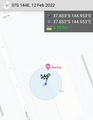
| Sat 12 Feb 2022 in -37,144: -37.8327256, 144.9534468 geohashing.info google osm bing/os kml crox |
Location
On the corner of a brick building in South Warf.
Participants
- Felix Dance
- Ruth
- John
- Steve
- EB
- Matt
- Rhonda
Expedition
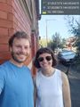
Felix and Ruth
I'd hit a 4 geohash streak so I was very interested to see where the next one would land. And yes! Very close in South Melbourne!
I was going to jaunt off my own in the morning (had a few things on in the afternoon when others were more likely to go down for it), but my girlfriend Ruth expressed interest in a little bike ride. So off we went!
The sky was sunny and the weather a perfect temperature. We rode down Moonee Ponds Creek and through the Docklands. We then navigated the annoying streets of Port Melbourne to reach the hash.
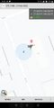
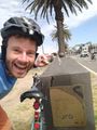
My phone got me to within 1.4m as I rode past so we stopped and walked around a bit to get the best spot. It looked like it was right along the wall of a brick building. Quite possibly the hash point was inside it but it was ambiguous from the satellite photo and the coordinates which jumped around a lot. Eventually I took a screen shot for within about 3m and called it a success.
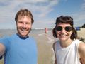
We got back on our bikes and rode to the beach, sticking our feet in the balmy water. We watched the Spirit of Tasmania sail across the bay towards Bass Strait, sailing boats framing it in the foreground.
We took bike paths along the way back, passing part of the 1:1 billion scale model of the solar system. I took a photo with me and Neptune.
All-in-all another ideal hash. The hash-gods certainly have been smiling on us lately.
This is geohash #5 of 6 of a consecutive geohashing achievement:
- 2022-02-08 -37 144
- 2022-02-09 -37 145
- 2022-02-10 -38 145
- 2022-02-11 -37 145
- 2022-02-12 -37 144
- 2022-02-13 -37 145
John

Two in a row! After yesterday's excellent location, this was even closer, though not quite as delightful a location. Even though it was even closer, I didn't want to do anything more exciting than just a quick ride past. I had had a slowish morning, after a late night the night before at my gig, and I had a picnic for a friend's 30th birthday to get to, (making it my second geohash involving a 30th birthday after this one). I headed off just on 3, and after riding up Footscray Rd and across the Docklands, I crossed the Yarra, reaching the "annoying streets" district that Felix mentioned. Thankfully there wasn't too much car traffic around, making the last section not too hair-raising of a ride. I found the hash point without too much difficulty, snapped a quick pic, and continued on my way, navigating across the Hoddle grid up to Carlton Gardens where the picnic was.
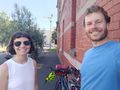
Steve and EB

Another amazingly close and convenient spot! Wow. It was looking like a hot day, so we waited till late afternoon to ride down. The weather was extraordinarily pleant - warm, but no longer the biting sun. As usual, in that part of the world, we fell into the "Let's ride down Montague St oh fuck no this is awful now what the fuck do we do I guess we take this shitty laneway oh no the laneways don't all connect let's try Ferrars St ah that's better" routine that we all know and love.
After posing by the now-iconic red brick wall, we cruised down to the beach and reminisced at the jetty I once jumped off to celebrate our sitting Prime Minister's loss of his own seat at the 2007 federal election. Then we stopped for fish and chips on Bay St, former residence of both Felix and Matt (did they ever overlap?).
On the final leg of our journey, riding up the Moonee Ponds Creek Trail, we found ourselves occupying positions 2 and 3 of a 4 person convoy. Seemingly the 4th person didn't have lights and preferred to sit on our tail. Meanwhile, we weren't really going fast enough to overtake #1. Accidentally overtaking slightly after a big downhill, I apologised, and discovered that person #1 was a friend of ours who lives nearby, so we had an overdue rolling catch-up. Ah, the inner north!
Matt and Rhonda

We had half a plan to go to the MSO free concert at the bowl, but it was a long way into town, and we weren't sure if we would make it in time. But news of a nearby geohash tipped the balance - we'd give the bowl a shot!
As we drove into town news came through from our friends - the bowl was filling fast, but they'd secured a small patch of grass, just as long as we could get in. To boost our chances, I dropped Rhonda as I drove by, and went off to buy some food and park the car. But we were a minute too late - capacity had just been reached when Rhonda reached the gate, so she set up the rug just outside - the music would still be audible.
But I had even less luck. I got the food, but then drove every road anywhere nearby, searching in vain for a car park. Eventually I gave up, and called Rhonda back to the car - we could go have a picnic somewhere else and enjoy the concert via the FM broadcast. Before that though, there was business to attend to! Easy enough to find a carpark in this particular corner of South Melbourne, so a quick walk and we were at the now-famous redbrick wall. A photo, then our own picnic, then ice cream, and off to my parents for the night.
This is geohash #1 of 3 of a consecutive geohashing achievement:
Tracklog
Photos
Geohash success! @-37.8329,144.9535
With bikes
GPS Proof
On the beach
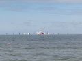
Ships
Neptune!
Success! @-37.8327,144.9534
Under 20cm (allegedly)


Achievements
Felix Dance, Ruth, John, Steve and EB earned the Bicycle geohash achievement
|
Felix Dance earned the Consecutive geohash achievement
|
Matt earned the Consecutive geohash achievement
|
This is hash #5 of the 2022 Victorian Geohash Streak.