Difference between revisions of "2022-07-08 58 5"
From Geohashing
m (Location) |
(→Participants) |
||
| Line 20: | Line 20: | ||
<!-- who attended: If you link to your wiki user name in this section, your expedition will be picked up by the various statistics generated for geohashing. You may use three tildes ~ as a shortcut to automatically insert the user signature of the account you are editing with. | <!-- who attended: If you link to your wiki user name in this section, your expedition will be picked up by the various statistics generated for geohashing. You may use three tildes ~ as a shortcut to automatically insert the user signature of the account you are editing with. | ||
--> | --> | ||
| − | [[User:Pica42|Pica42]] | + | *[[User:Pica42|Pica42]] |
== Plans == | == Plans == | ||
Latest revision as of 10:40, 20 July 2022
| Fri 8 Jul 2022 in 58,5: 58.9050175, 5.9414307 geohashing.info google osm bing/os kml crox |
Location
Eikelivatnet near Ims in Sandnes, Norway
Participants
Plans
Expedition
This is the first time I have tried a hash that was not on land, it was some distance out on a lake called Eikelivatnet and is located in Sandnes municipality, Norway. I had big problems seeing the screen on the phone due to sunshine so it was not easy to find the zero point. In addition, there was some wind which, as soon as I stopped paddling, the kayak was taken by the wind and moved away from the hash. It was still a nice but short paddle.
Tracklog
Photos
Eikelivatnet
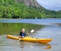
Me at Eikelivatnet


Achievements
Pica42 earned the Water geohash achievement
|