Difference between revisions of "2013-09-28 52 -0"
imported>Sourcerer m (An expedition message sent via Geohash Droid for Android.) |
m (Location correction) |
||
| (9 intermediate revisions by 2 users not shown) | |||
| Line 1: | Line 1: | ||
| − | |||
| − | |||
| − | |||
| − | |||
| − | |||
| − | |||
| − | |||
| − | |||
| − | |||
| − | |||
{{meetup graticule | {{meetup graticule | ||
| − | | lat=52 | + | | lat=52 |
| − | | lon=-0 | + | | lon=-0 |
| − | | date=2013-09-28 | + | | date=2013-09-28 |
| + | | graticule_name=Northampton, UK | ||
| + | | graticule_link=Northampton, United Kingdom | ||
}} | }} | ||
| − | |||
| − | |||
__NOTOC__ | __NOTOC__ | ||
== Location == | == Location == | ||
| − | + | ||
| + | 1) At Duddington, a few metres east of the A43 south of the roundabout where it crosses the A47. | ||
== Participants == | == Participants == | ||
| − | |||
| − | |||
| − | + | [[User:Sourcerer|Sourcerer]] | |
| − | + | ||
== Expedition == | == Expedition == | ||
| − | |||
| − | == | + | *Arrived. -- [[User:Sourcerer|Sourcerer]] ([[User talk:Sourcerer|talk]]) [http://www.openstreetmap.org/?lat=52.59755551815033&lon=-0.5360662937164307&zoom=16&layers=B000FTF @52.5976,-.5361] 11:55, 28 September 2013 (GMT+01:00) |
| − | + | ||
| + | Attempt 1 of 3 today :: [[2013-09-28 52 -0]] :: [[2013-09-28 52 0]] :: [[2013-09-28 52 1]] | ||
| + | |||
| + | There was an access road to agricultural land where it was possible to park the car. A couple of hundred metres north and up a steep bank roadside cutting, there was the hashpoint. I got to within 8 metres on the wrong side of a well maintained human and animal proof hedge. On the other side, not far away was a public footpath so the point was reachable. I didn't think it was necessary to walk the extra distance to stand on the exact spot. Sliding down the bank in a manoeuvre I call a glassade, I had a flash of memory from my childhood of the joy of sliding down a steep hill on ones backside. Fun! | ||
== Photos == | == Photos == | ||
| − | + | ||
| − | |||
| − | |||
<gallery perrow="5"> | <gallery perrow="5"> | ||
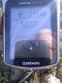
| + | Image:2013-09-28 52 -0 Sourcerer 1.jpg | Proof | ||
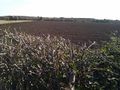
| + | Image:2013-09-28 52 -0 Sourcerer 2.jpg | The Point | ||
| + | Image:2013-09-28 52 -0 Sourcerer 3.jpg | Track in Google Earth | ||
</gallery> | </gallery> | ||
| − | == | + | {{Sourcerer_links |
| − | + | | prev = 2013-09-07 51 0 | |
| − | + | | curr = 2013-09-28 52 -0 | |
| + | | next = 2013-09-28 52 0 | ||
| + | | date = 2013-09-28 | ||
| + | }} | ||
| − | |||
| − | |||
| − | |||
| − | |||
| − | |||
| − | |||
| − | |||
| − | |||
| − | |||
| − | |||
| − | |||
[[Category:Expeditions]] | [[Category:Expeditions]] | ||
| − | |||
[[Category:Expeditions with photos]] | [[Category:Expeditions with photos]] | ||
| − | |||
| − | |||
| − | |||
| − | |||
| − | |||
[[Category:Coordinates reached]] | [[Category:Coordinates reached]] | ||
| − | + | {{location|GB|ENG|NNH}} | |
| − | |||
| − | |||
| − | |||
| − | |||
| − | |||
| − | |||
| − | |||
| − | |||
| − | |||
| − | |||
| − | |||
| − | |||
| − | |||
| − | |||
| − | |||
| − | |||
| − | |||
Latest revision as of 14:12, 4 December 2022
| Sat 28 Sep 2013 in Northampton, UK: 52.5975143, -0.5359618 geohashing.info google osm bing/os kml crox |
Location
1) At Duddington, a few metres east of the A43 south of the roundabout where it crosses the A47.
Participants
Expedition
- Arrived. -- Sourcerer (talk) @52.5976,-.5361 11:55, 28 September 2013 (GMT+01:00)
Attempt 1 of 3 today :: 2013-09-28 52 -0 :: 2013-09-28 52 0 :: 2013-09-28 52 1
There was an access road to agricultural land where it was possible to park the car. A couple of hundred metres north and up a steep bank roadside cutting, there was the hashpoint. I got to within 8 metres on the wrong side of a well maintained human and animal proof hedge. On the other side, not far away was a public footpath so the point was reachable. I didn't think it was necessary to walk the extra distance to stand on the exact spot. Sliding down the bank in a manoeuvre I call a glassade, I had a flash of memory from my childhood of the joy of sliding down a steep hill on ones backside. Fun!
Photos
Proof
The Point
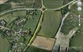
Track in Google Earth


Expeditions and Plans
| 2013-09-28 | ||
|---|---|---|
| Newark, New Jersey | Jevanyn | April Dr., Bridgewater. |
| Montauban, France | Pastori, The Wife | In a field near Saint-Martin-de-Vers, France. |
| Zürich, Switzerland | Someone went | A field near Rafz. |
| Northampton, United Kingdom | Sourcerer | 1) At Duddington, a few metres east of the A43 south of the roundabout wher... |
| Cambridge, United Kingdom | Sourcerer | 2) East of Downham Market, Norfolk, UK. |
| Norwich, United Kingdom | Sourcerer | 3) A road hashpoint north of the sugar refinery at Cantley, Norfolk, UK. |
| Moscow, Russia | vb | The corner of Golubinskaya str. and Paustovskogo str. in Yasenevo district.... |
Sourcerer's Expedition Links
2013-09-07 51 0 - 2013-09-28 52 -0 - 2013-09-28 52 0 - KML file download of Sourcerer's expeditions for use with Google Earth.