Difference between revisions of "2023-02-05 45 -122"
Michael5000 (talk | contribs) (Created page with "{{subst:Expedition}}") |
m (Location) |
||
| (2 intermediate revisions by one other user not shown) | |||
| Line 1: | Line 1: | ||
| − | + | {{meetup graticule | |
| − | |||
| − | |||
| − | |||
| − | |||
| − | |||
| − | |||
| − | |||
| − | |||
| lat={{#explode:{{SUBPAGENAME}}| |1}} | | lat={{#explode:{{SUBPAGENAME}}| |1}} | ||
| lon={{#explode:{{SUBPAGENAME}}| |2}} | | lon={{#explode:{{SUBPAGENAME}}| |2}} | ||
| Line 13: | Line 5: | ||
}}<!-- edit as necessary --> | }}<!-- edit as necessary --> | ||
== Location == | == Location == | ||
| − | + | ||
| + | On 129th Street, off Division in SE Portland. | ||
== Participants == | == Participants == | ||
| − | |||
| − | |||
| − | + | * [[User:Michael5000|Michael5000]] | |
| − | |||
== Expedition == | == Expedition == | ||
| − | |||
| − | + | I thought about several possible approaches to this hashpoint, but after consulting the weather decided on a transit-to-run sort of affair. I had a little bit of uninteresting fiasco getting a transit card, after which I rode Bus #15 out to a point about a mile and a half from the hashpoint, and started jogging through intermittent drizzle. | |
| − | + | ||
| + | The point was on a residential street not far from an apartment building where I used to know some folks, although strangely I didn't notice that until I was back home looking at the pictures. Before I got there, and after I left, it occurred to me that it's not impossible other people would claim this hashpoint, and I might leave some kind of trace. While standing on the spot, though, that thought escaped me. I took some pictures and then ran another 5 1/2 miles until I ran out of steam and walked the rest of the way home. | ||
== Photos == | == Photos == | ||
| − | + | ||
| − | |||
| − | |||
<gallery perrow="5"> | <gallery perrow="5"> | ||
| + | File:45 -122 2023-02-05 1.jpg|Me, having acquired transit card | ||
| + | File:45 -122 2023-02-05 2.jpg|The general area, at Division and 122nd | ||
| + | File:45 -122 2023-02-05 3.jpg|Turning on to 129th Avenue | ||
| + | File:45 -122 2023-02-05 4.jpg|The hashpoint! In the squarish area of cracked concrete in foreground | ||
| + | File:45 -122 2023-02-05 5.jpg|Yes indeed | ||
</gallery> | </gallery> | ||
== Achievements == | == Achievements == | ||
{{#vardefine:ribbonwidth|100%}} | {{#vardefine:ribbonwidth|100%}} | ||
| − | |||
| − | + | {{Public transport geohash | |
| − | |||
| − | |||
| − | |||
| − | + | | latitude = 45 | |
| + | | longitude = -122 | ||
| + | | date = 2023-02-05 | ||
| + | | busline = Trimet Bus #15 | ||
| + | | name = Michael5000 | ||
| + | }} | ||
| − | |||
| − | |||
| − | |||
| − | |||
| − | + | __NOTOC__ | |
| − | |||
| − | |||
[[Category:Expeditions]] | [[Category:Expeditions]] | ||
| − | |||
[[Category:Expeditions with photos]] | [[Category:Expeditions with photos]] | ||
| − | |||
| − | |||
| − | |||
| − | |||
| − | |||
[[Category:Coordinates reached]] | [[Category:Coordinates reached]] | ||
| − | + | {{location|US|OR|MU}} | |
| − | |||
| − | |||
| − | |||
| − | |||
| − | |||
| − | |||
| − | |||
| − | |||
| − | |||
| − | |||
| − | |||
| − | |||
| − | |||
| − | |||
| − | |||
| − | |||
| − | |||
Latest revision as of 22:42, 5 February 2023
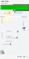
| Sun 5 Feb 2023 in 45,-122: 45.5024761, -122.5311716 geohashing.info google osm bing/os kml crox |
Location
On 129th Street, off Division in SE Portland.
Participants
Expedition
I thought about several possible approaches to this hashpoint, but after consulting the weather decided on a transit-to-run sort of affair. I had a little bit of uninteresting fiasco getting a transit card, after which I rode Bus #15 out to a point about a mile and a half from the hashpoint, and started jogging through intermittent drizzle.
The point was on a residential street not far from an apartment building where I used to know some folks, although strangely I didn't notice that until I was back home looking at the pictures. Before I got there, and after I left, it occurred to me that it's not impossible other people would claim this hashpoint, and I might leave some kind of trace. While standing on the spot, though, that thought escaped me. I took some pictures and then ran another 5 1/2 miles until I ran out of steam and walked the rest of the way home.
Photos

Me, having acquired transit card
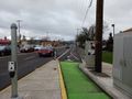
The general area, at Division and 122nd
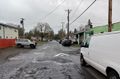
Turning on to 129th Avenue
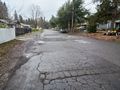
The hashpoint! In the squarish area of cracked concrete in foreground
Yes indeed


Achievements
Michael5000 earned the Public transport geohash achievement
|