Difference between revisions of "2023-08-19 45 -122"
Michael5000 (talk | contribs) (Created page with "{{subst:Expedition}}") |
Michael5000 (talk | contribs) (→Achievements) |
||
| (6 intermediate revisions by 2 users not shown) | |||
| Line 13: | Line 13: | ||
}}<!-- edit as necessary --> | }}<!-- edit as necessary --> | ||
== Location == | == Location == | ||
| − | + | In the woods northwest of Columbia City. | |
== Participants == | == Participants == | ||
| − | + | *[[user:Michael5000|Michael5000]] | |
| − | |||
== Plans == | == Plans == | ||
| − | + | The original plan was to head south to Salem and [[2023-08-19 44 -122]]. I made a snap decision in the driveway, though, and pointed the prow northward along US 30. | |
== Expedition == | == Expedition == | ||
| − | |||
| − | + | I turned off the highway at the little Deer Island community and then quickly turned left again to start up exactly the kind of rough gravel road the expedition was made for! And soon reached a gate. So, for the first of three times this day, I took out the bicycle -- also good on rough roads -- and continued uphill for about a half mile. | |
| − | + | ||
| + | The hashpoint was on the crest of a steep hill of fairly young forest, all of it thicketed in pretty heavily with blackberries and other ground vegetation. I all but circled it on the available roads, never more than a couple hundred meters away, but couldn't find any way to get off the road into the forest. Eventually I surrendered, enjoyed the downhill glide back to the truck, and continued towards [[2023-08-19 45 -123]]. | ||
== Photos == | == Photos == | ||
| − | |||
| − | |||
| − | |||
<gallery perrow="5"> | <gallery perrow="5"> | ||
| + | File:2023-08-19 45 -122 a.jpg|Turning left onto the logging road | ||
| + | File:2023-08-19 45 -122 b.jpg|Switching vehicles | ||
| + | File:2023-08-19 45 -122 c.jpg|The hashpoint is within the thick forest above the roadcut, straight ahead | ||
| + | File:2023-08-19 45 -122 d.jpg|This is the best route I found into the woods. Not very good. | ||
</gallery> | </gallery> | ||
| Line 40: | Line 40: | ||
__NOTOC__ | __NOTOC__ | ||
| − | |||
| − | |||
| − | |||
| − | |||
| − | |||
| − | |||
| − | |||
| − | |||
| − | |||
| − | |||
| − | |||
| − | |||
| − | |||
| − | |||
[[Category:Expeditions]] | [[Category:Expeditions]] | ||
| − | |||
[[Category:Expeditions with photos]] | [[Category:Expeditions with photos]] | ||
| − | |||
| − | |||
| − | |||
| − | |||
| − | |||
| − | |||
| − | |||
| − | |||
| − | |||
[[Category:Coordinates not reached]] | [[Category:Coordinates not reached]] | ||
| − | |||
| − | |||
[[Category:Not reached - Mother Nature]] | [[Category:Not reached - Mother Nature]] | ||
| − | + | {{location|US|OR|CL}} | |
| − | |||
| − | |||
| − | |||
| − | |||
| − | |||
| − | |||
| − | |||
| − | |||
| − | |||
| − | |||
Latest revision as of 13:52, 25 August 2023
| Sat 19 Aug 2023 in 45,-122: 45.9243995, -122.8580770 geohashing.info google osm bing/os kml crox |
Location
In the woods northwest of Columbia City.
Participants
Plans
The original plan was to head south to Salem and 2023-08-19 44 -122. I made a snap decision in the driveway, though, and pointed the prow northward along US 30.
Expedition
I turned off the highway at the little Deer Island community and then quickly turned left again to start up exactly the kind of rough gravel road the expedition was made for! And soon reached a gate. So, for the first of three times this day, I took out the bicycle -- also good on rough roads -- and continued uphill for about a half mile.
The hashpoint was on the crest of a steep hill of fairly young forest, all of it thicketed in pretty heavily with blackberries and other ground vegetation. I all but circled it on the available roads, never more than a couple hundred meters away, but couldn't find any way to get off the road into the forest. Eventually I surrendered, enjoyed the downhill glide back to the truck, and continued towards 2023-08-19 45 -123.
Photos
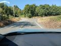
Turning left onto the logging road
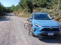
Switching vehicles
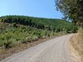
The hashpoint is within the thick forest above the roadcut, straight ahead
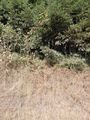
This is the best route I found into the woods. Not very good.


