Difference between revisions of "2009-02-18 67 21"
imported>The ru |
m (per Renaming Proposal) |
||
| (10 intermediate revisions by 5 users not shown) | |||
| Line 12: | Line 12: | ||
* Muffin(s) eaten: 0.5 | * Muffin(s) eaten: 0.5 | ||
| − | My relationship with [[Vittangi, Sweden | 67 21]] has been strained ever since my aborted [[2009-01-17 67 21]] expedition. This turned out to be a fine day. | + | My relationship with [[Vittangi, Sweden | 67 21]] has been strained ever since my aborted [[2009-01-17 67 21 | 2009-01-17]] expedition. This turned out to be a fine day. |
| − | I started out around seven in the morning, drove south along E10. Most of my recent hashes have been along this road, nothing out of the ordinary happened. I was unsure what road actually | + | I started out around seven in the morning, drove south along E10. Most of my recent hashes have been along this road, nothing out of the ordinary happened. I was unsure what road actually led to Ullatti so I ended up driving some distance in the wrong direction. I've been on numerous road trips and have plenty of maps - why are none of them in my car? |
Anyway, I got on the right road (394), passed through Ullatti and parked near a bridge. About 700 m to go, so I put on my skis. The terrain in this area is very uneven, but the way to the hashpoint was almost entirely flat. | Anyway, I got on the right road (394), passed through Ullatti and parked near a bridge. About 700 m to go, so I put on my skis. The terrain in this area is very uneven, but the way to the hashpoint was almost entirely flat. | ||
| − | I was hoping to beat my previous Coldest Geohash. At first | + | I was hoping to beat my previous [[Cold Geohash | Coldest Geohash]]. At first the thermometer would only display -20 C. I assumed it was picking up some of my body heat, so I left it alone on the ground for a while. It finally dropped to -22.9, 0.1 degree below my previous record. |
| − | + | When I checked the thermometer back at the car, it had recorded a minimum of -24.4 degrees somewhere along the way. The accuracy of these cheap thermometers is questionable. I did some partial geoflashing to get myself into dry and warm clothes, then had some hot fruit soup. | |
| − | + | On the way home, I took some photos of Ullatti. I also drove through the villages Leipojärvi and Sakajärvi, but didn't see anything of interest. Trivia: almost all place names in this area are of finnish or sami origin. | |
| + | I also went to the Aitik copper mine. Since I can't get inside the gates, I just took a photo from the parking lot. I stopped by the bakery in Puoltikasvaara to have some tea and a muffin. [http://www.reallifecomics.com/archive/011206.html The Muffin] wasn't very good. | ||
| − | {{Cold | + | |
| + | {{Graticule unlocked | latitude = 67 | longitude = 21 | date = 2009-02-18 | name = [[User:the_ru | the ru]] | image = 2009-02-18_67_21_proof.jpg}} | ||
| + | |||
| + | |||
| + | {{Minesweeper geohash | graticule = Kiruna, Sweden | ranknumber = 2 | se = true | e = true | name = [[User:the_ru | the ru]] }} | ||
| + | |||
| + | |||
| + | {{Cold geohash | ||
| latitude = 67 | | latitude = 67 | ||
| longitude = 21 | | longitude = 21 | ||
| Line 38: | Line 46: | ||
| − | <gallery perrow=" | + | <gallery perrow="4"> |
| + | Image:2009-02-18_67_21_morning.jpg | Morning sun | ||
Image:2009-02-18_67_21_forest.jpg | Terrain | Image:2009-02-18_67_21_forest.jpg | Terrain | ||
Image:2009-02-18_67_21_frost.jpg | Frost on a young birch | Image:2009-02-18_67_21_frost.jpg | Frost on a young birch | ||
| − | Image:2009-02- | + | Image:2009-02-18_67_21_power.jpg | I passed under some power lines |
| + | |||
Image:2009-02-18_67_21_hashpoint.jpg | The hashpoint | Image:2009-02-18_67_21_hashpoint.jpg | The hashpoint | ||
| + | Image:2009-02-18_67_21_proof.jpg | Location & temperature | ||
| + | |||
| + | Image:2009-02-18_67_21_tracks1.jpg | Peculiar animal tracks - not sure what could have made this | ||
| + | Image:2009-02-18_67_21_tracks2.jpg | More tracks - ??? | ||
| + | Image:2009-02-18_67_21_tracks3.jpg | Hare tracks | ||
| + | |||
Image:2009-02-18_67_21_min.jpg | Lowest temperature recorded during the expedition, but not at the hashpoint | Image:2009-02-18_67_21_min.jpg | Lowest temperature recorded during the expedition, but not at the hashpoint | ||
| − | Image:2009-02- | + | Image:2009-02-18_67_21_fruit_soup.jpg | Fruit soup! |
| − | Image:2009-02- | + | Image:2009-02-18_67_21_reindeer.jpg | A reindeer along E10 |
| − | + | ||
| − | |||
| − | |||
| − | |||
| − | |||
Image:2009-02-18_67_21_aitik.jpg | Aitik | Image:2009-02-18_67_21_aitik.jpg | Aitik | ||
| − | Image:2009-02-18_67_21_bakery.jpg | The Puoltikasvaara | + | Image:2009-02-18_67_21_bakery.jpg | The Puoltikasvaara [http://xkcd.com/452/ bakery] |
| − | |||
</gallery> | </gallery> | ||
=== Ullatti === | === Ullatti === | ||
| − | <gallery perrow=" | + | <gallery perrow="4"> |
Image:2009-02-18_67_21_ullatti1.jpg | West | Image:2009-02-18_67_21_ullatti1.jpg | West | ||
Image:2009-02-18_67_21_ullatti2.jpg | East | Image:2009-02-18_67_21_ullatti2.jpg | East | ||
| Line 67: | Line 78: | ||
=== Warning Signs === | === Warning Signs === | ||
| − | <gallery perrow=" | + | <gallery perrow="4"> |
Image:2009-02-18_67_21_warning1.jpg | Beware of reindeer | Image:2009-02-18_67_21_warning1.jpg | Beware of reindeer | ||
Image:2009-02-18_67_21_warning2.jpg | Beware of moose | Image:2009-02-18_67_21_warning2.jpg | Beware of moose | ||
| Line 78: | Line 89: | ||
[[Category:Expeditions]] | [[Category:Expeditions]] | ||
[[Category:Expeditions with photos]] | [[Category:Expeditions with photos]] | ||
| + | [[Category:Coordinates reached]] | ||
| + | {{location|SE|BD}} | ||
Latest revision as of 06:37, 20 March 2024
| Wed 18 Feb 2009 in 67,21: 67.0069813, 21.9305498 geohashing.info google osm bing/os kml crox |
The hashpoint was in the forest near the village Ullatti.
the ru
- Distance traveled: 389 km (1.5 on skis)
- Phone call(s): 4
- Muffin(s) eaten: 0.5
My relationship with 67 21 has been strained ever since my aborted 2009-01-17 expedition. This turned out to be a fine day.
I started out around seven in the morning, drove south along E10. Most of my recent hashes have been along this road, nothing out of the ordinary happened. I was unsure what road actually led to Ullatti so I ended up driving some distance in the wrong direction. I've been on numerous road trips and have plenty of maps - why are none of them in my car?
Anyway, I got on the right road (394), passed through Ullatti and parked near a bridge. About 700 m to go, so I put on my skis. The terrain in this area is very uneven, but the way to the hashpoint was almost entirely flat.
I was hoping to beat my previous Coldest Geohash. At first the thermometer would only display -20 C. I assumed it was picking up some of my body heat, so I left it alone on the ground for a while. It finally dropped to -22.9, 0.1 degree below my previous record.
When I checked the thermometer back at the car, it had recorded a minimum of -24.4 degrees somewhere along the way. The accuracy of these cheap thermometers is questionable. I did some partial geoflashing to get myself into dry and warm clothes, then had some hot fruit soup.
On the way home, I took some photos of Ullatti. I also drove through the villages Leipojärvi and Sakajärvi, but didn't see anything of interest. Trivia: almost all place names in this area are of finnish or sami origin.
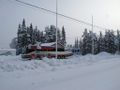
I also went to the Aitik copper mine. Since I can't get inside the gates, I just took a photo from the parking lot. I stopped by the bakery in Puoltikasvaara to have some tea and a muffin. The Muffin wasn't very good.
the ru earned the Graticule Unlocked Achievement
|
the ru achieved level 2 of the Minesweeper Geohash achievement
|
the ru earned the Cold geohash achievement
|
the ru earned the Land geohash achievement
|
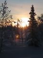
Morning sun
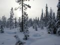
Terrain
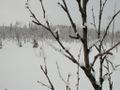
Frost on a young birch
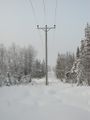
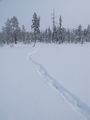
I passed under some power lines
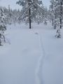
The hashpoint
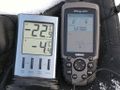
Location & temperature
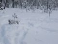
Peculiar animal tracks - not sure what could have made this
More tracks - ???
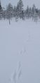
Hare tracks
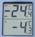
Lowest temperature recorded during the expedition, but not at the hashpoint
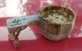
Fruit soup!
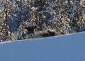
A reindeer along E10
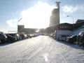
Aitik
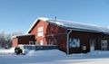
The Puoltikasvaara bakery


Ullatti
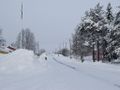
West
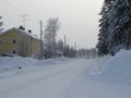
East
It's A
KittyBus!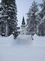
Church


Warning Signs
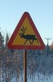
Beware of reindeer
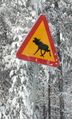
Beware of moose


I also saw "Beware of children" and "Beware of horse", but I was too slow to get pictures of them.