Difference between revisions of "2009-04-28"
From Geohashing
imported>Ncbears (New page: <noinclude>{{date navigation}}</noinclude> {{auto coordinates|2009-04-28}} {{auto gallery|2009-04-28}}) |
imported>ReletBot m (moving from Template:auto gallery to Template:auto gallery2) |
||
| (One intermediate revision by one other user not shown) | |||
| Line 1: | Line 1: | ||
<noinclude>{{date navigation}}</noinclude> | <noinclude>{{date navigation}}</noinclude> | ||
{{auto coordinates|2009-04-28}} | {{auto coordinates|2009-04-28}} | ||
| − | {{auto | + | {{auto gallery2|2009-04-28}} |
| + | <noinclude>{{expedition summaries|2009-04-28}}</noinclude> | ||
Latest revision as of 22:28, 23 August 2010
Expedition Archives from April 2009
Monday 27 April 2009 | Tuesday 28 April 2009 | Wednesday 29 April 2009
See also: Category:Meetup on 2009-04-28
Coordinates
West of -30°: .2375398, .8303430
East of -30°: .1044299, .0306686
Globalhash:
-71.202617406628,-168.959320472700
Photo Gallery
Expeditions and Plans
| 2009-04-28 | ||
|---|---|---|
| Sutherland, Australia | Someone went | In the Royal National Park. 5 km bushwalk from Heathcote. |
| Tucson, Arizona | Yert | Easy geohash, as it is just in the city, by Speedway and Pantano. |
| Jackson, Mississippi | Uglystick's | The sixth geohash for my (Uglystick's) home graticule was pretty simple - a... |
| Newburgh, New York | GISninja | Writeup to follow |
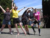
| Surrey, British Columbia | Robyn, Rhonda, SueB, yangman | in the Surrey graticule appears to be in somebody's kitchen (or at least, j... |
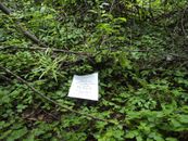
| Regensburg, Germany | dawidi, Tomcat | On the edge of a forest near Schweighausen, about 10km northwest of Regensb... |