Difference between revisions of "2010-02-21 49 -2"
From Geohashing
imported>Jiml m (Add sections) |
m (Replacing Peeron with Geohashing.info) |
||
| (2 intermediate revisions by 2 users not shown) | |||
| Line 12: | Line 12: | ||
The location for Sun 21st Feb 2010 is on land, in Jersey! | The location for Sun 21st Feb 2010 is on land, in Jersey! | ||
| − | Here: | + | Here: https://geohashing.info/s/2010-02-21/49,-3 |
==Participants== | ==Participants== | ||
* [[User:d7415|d7415]] | * [[User:d7415|d7415]] | ||
| + | |||
==Planning== | ==Planning== | ||
| Line 22: | Line 23: | ||
| + | ==Report== | ||
| + | By d7415 | ||
| + | |||
| + | [[File:20100221 49 -2 Drive-by.jpg|200px|thumb|left|A bit blurry]] | ||
| + | [[File:20100221 49 -2 Aerial GPS.jpg|200px|thumb|right|This is the closest that I managed to photograph]] | ||
| + | [[File:20100221 49 -2 Android GPS.jpg|200px|thumb|left|Made it!]] | ||
| + | [[File:20100221 49 -2 Aerial Photo Zoom.jpg|200px|thumb|right|Aerial view]] | ||
| + | I made 3 "visits" to the site today. The first was on my way to work. I probably passed within a metre or two while driving, at 5am. | ||
| + | |||
| + | |||
| + | |||
| + | After work, I flew some circuits with my dad, and the site was pretty much exactly under the circuit. | ||
| + | |||
| + | |||
| + | |||
| + | |||
| + | Finally, after the flying, I took my dad to the site by car. We parked in a nearby car park (to the right of the cropped aerial photo) shortly after 4pm, and used his HTC Hero to find our way. | ||
| + | |||
| + | |||
| + | {{air geohash | latitude = 49 | longitude = -2 | date = 2010-02-21 | name = d7415 | vehicle = Cessna 172 | subcategory = Pilot }} | ||
| − | [[Category: | + | [[Category:Expeditions]] |
| + | [[Category:Coordinates reached]] | ||
| + | [[Category:Expeditions with photos]] | ||
| + | {{location|JE|PE}} | ||
Latest revision as of 13:01, 17 January 2022
| Sun 21 Feb 2010 in Channel Islands: 49.1965597, -2.1560514 geohashing.info google osm bing/os kml crox |
Contents
Location
Jersey, in the Channel islands
The location for Sun 21st Feb 2010 is on land, in Jersey!
Here: https://geohashing.info/s/2010-02-21/49,-3
Participants
Planning
d7415 will make an attempt, though might be late. If anyone wishes to meet him there, add your name here and we can sort something out.
Report
By d7415
I made 3 "visits" to the site today. The first was on my way to work. I probably passed within a metre or two while driving, at 5am.
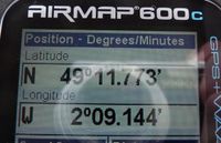
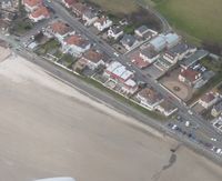
After work, I flew some circuits with my dad, and the site was pretty much exactly under the circuit.
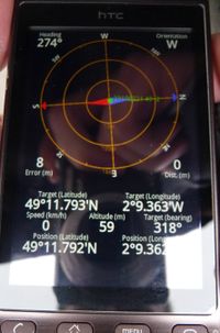
Finally, after the flying, I took my dad to the site by car. We parked in a nearby car park (to the right of the cropped aerial photo) shortly after 4pm, and used his HTC Hero to find our way.
d7415 earned the Air geohash achievement
|


