Difference between revisions of "2011-01-27 52 1"
From Geohashing
imported>Sourcerer (Created page with "== Location == In Back Lane, Burgh Castle, Norfolk, UK {{meetup graticule | lat=52 | lon=1 | date=2011-01-27 | graticule_name=Norwich | graticule_link=Norwi...") |
imported>FippeBot m (Location) |
||
| (6 intermediate revisions by one other user not shown) | |||
| Line 1: | Line 1: | ||
| − | |||
| − | |||
| − | |||
| − | |||
{{meetup graticule | {{meetup graticule | ||
| lat=52 | | lat=52 | ||
| Line 8: | Line 4: | ||
| date=2011-01-27 | | date=2011-01-27 | ||
| graticule_name=Norwich | | graticule_name=Norwich | ||
| − | | graticule_link=Norwich, United Kingdom}} | + | | graticule_link=Norwich, United Kingdom |
| + | }} | ||
| + | |||
| + | == Location == | ||
| + | |||
| + | In Back Lane, Burgh Castle, Norfolk, UK | ||
== Participants == | == Participants == | ||
| Line 20: | Line 21: | ||
== Photo Gallery == | == Photo Gallery == | ||
| − | <gallery | + | <gallery> |
Image:2011-01-27_52_1_Sourcerer_1.jpg|The House at the Hashpoint | Image:2011-01-27_52_1_Sourcerer_1.jpg|The House at the Hashpoint | ||
</gallery> | </gallery> | ||
| − | == | + | == Achievements == |
| + | {{Two to the N achievement | ||
| + | | count = 5 | ||
| + | | date = 2011-01-27 | ||
| + | | latitude = 52 | ||
| + | | longitude = 1 | ||
| + | | name = Sourcerer | ||
| + | | reached = true | ||
| + | }} | ||
| − | {{ | + | {{Sourcerer_links |
| + | | prev = 2011-01-17 52 0 | ||
| + | | curr = 2011-01-27 52 1 | ||
| + | | next = 2011-02-06 52 1 | ||
| + | | date = 2011-01-27 | ||
| + | }} | ||
| + | [[Category:Expeditions]] | ||
[[Category:Expeditions with photos]] | [[Category:Expeditions with photos]] | ||
[[Category:Coordinates reached]] | [[Category:Coordinates reached]] | ||
| − | + | {{location|GB|ENG|NFK}} | |
| − | |||
Latest revision as of 05:22, 9 August 2019
| Thu 27 Jan 2011 in Norwich: 52.5888717, 1.6707605 geohashing.info google osm bing/os kml crox |
Contents
Location
In Back Lane, Burgh Castle, Norfolk, UK
Participants
Expedition
This was a surprise success. Google maps and Earth both showed the hashpoint, at best in a private garden, and at worst, inside a private house. The point was shown five metres from the centre of the road but this is also the approximate accuracy of the positioning of the Google maps. On a drive-by, Geohash Droid showed the distance which dropped to 1 +/- 3 metres. On the second drive-by the house got its photo taken as evidence.
Photo Gallery
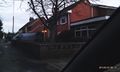
The House at the Hashpoint

Achievements

Sourcerer earned the Two to the N achievement
by reaching 25 hashpoints on 2011-01-27 52 1 and is promoted to Level 5 (Coordinates reached).
Expeditions and Plans
| 2011-01-27 | ||
|---|---|---|
| Atlanta, Georgia | NWoodruff | off to the side of the road in a construction site in Decatur. |
| Seattle, Washington | Thomcat | Satellite reveals it to be on Interstate 405 at the edge of an emergency ve... |
| Mannheim, Germany | Rincewind | On the hills overlooking smalltown Hemsbach in the Odenwald area. Right in ... |
| Frankfurt am Main, Germany | Yakamoz | An older house in Gießen's inner city. |
| Norwich, United Kingdom | Sourcerer | In Back Lane, Burgh Castle, Norfolk, UK |
| Sheffield, United Kingdom | amc, myka, Monty | Skelmanthorpe, near Huddersfield. Just under 7 metres from an unmarked road... |
| Hamburg (West), Germany | Hermann | An tree in an apple farm between the dike and the outlines of the city "Wed... |
Sourcerer's Expedition Links
2011-01-17 52 0 - 2011-01-27 52 1 - 2011-02-06 52 1 - KML file download of Sourcerer's expeditions for use with Google Earth.