Difference between revisions of "2011-08-16 52 1"
imported>Jiml m (Adjust result codes) |
imported>FippeBot m (Location) |
||
| (8 intermediate revisions by 2 users not shown) | |||
| Line 1: | Line 1: | ||
| − | |||
| − | |||
| − | |||
| − | |||
| − | |||
| − | |||
| − | |||
| − | |||
| − | |||
{{meetup graticule | {{meetup graticule | ||
| − | | lat=52 | + | | lat=52 |
| − | | lon=1 | + | | lon=1 |
| − | | date=2011-08-16 | + | | date=2011-08-16 |
| + | | graticule_name=Norwich | ||
| + | | graticule_link=Norwich, United Kingdom | ||
}} | }} | ||
| − | |||
| − | |||
== Location == | == Location == | ||
| − | + | ||
| + | On the Tas Valley Way, 400 metres north west of Mulbarton and 8.5 km south west of Norwich, Norfolk, UK. | ||
== Participants == | == Participants == | ||
| − | |||
| − | + | [[User:Sourcerer|Sourcerer]] - arrived separately at 11:08 | |
| − | + | ||
| + | and | ||
| + | |||
| + | [[User:MagicIan|MagicIan]] - arrived separately at 18:30 | ||
== Expedition == | == Expedition == | ||
| − | |||
| + | [[User:Sourcerer|Sourcerer]]: | ||
| + | Neil set out by car on various errands, taking in today's hashpoint on the way. | ||
| + | |||
| + | * On arrival, my droid logged into the wiki and left this message:<br />'''Arrived. -- [[User:Sourcerer|Sourcerer]] [http://www.openstreetmap.org/?lat=52.56360948085785&lon=1.2262094020843506&zoom=16&layers=B000FTF @52.5636,1.2262] 11:08, 16 August 2011 (GMT+01:00)''' | ||
| + | |||
| + | The expedition was easy and routine. I parked by the church and walked a few hundred metres to the hashpoint which was right on a public footpath. Geohashing in this part of the world can be really easy. Every week or so there seems to be a hashpoint on or very near a public path. History has left us with so many public paths. It's great. | ||
| + | |||
| + | Today was a day of jelly-sky (Jell-O-sky). While standing still the GPSr seemed to be wandering about over a +/- 5 metre radius. There were big cumulus convection clouds making the satellites wobble. | ||
| + | |||
| + | |||
| + | |||
| + | [[User:MagicIan|MagicIan]] lives within a 10 minute walk of the hashpoint, so had an even easier time to get there. He got back from work, had dinner and then went for an lovely sunny summer evening stroll, doing a circular route which he had done as part of a longer hike sometime in the past. | ||
| + | His route crossed Mulbarton, down the side of some houses and across the horse field to get onto the Tas Valley Way. Once photos at the hashpoint were completed he carried on and returned by way of the road. | ||
| + | |||
| + | == Achievements == | ||
| + | |||
| + | {{Earliest geohasher | ||
| + | | latitude = 52 | ||
| + | | longitude = 1 | ||
| + | | date = 2011-08-16 | ||
| + | | name = [[User:Sourcerer|Sourcerer]] | ||
| + | }} | ||
| + | |||
| + | {{Walk geohash | ||
| + | | latitude = 52 | ||
| + | | longitude = 1 | ||
| + | | date = 2011-08-16 | ||
| + | | name = [[User:MagicIan|MagicIan]] | ||
| + | | distance = 2.0km | ||
| + | }} | ||
| − | |||
| − | |||
| − | |||
== Photos == | == Photos == | ||
| − | + | ||
| − | |||
| − | |||
<gallery perrow="5"> | <gallery perrow="5"> | ||
| + | Image:2011-08-16_52_1_Sourcerer_0.jpg|Google Earth Track | ||
| + | Image:2011-08-16_52_1_Sourcerer_1.jpg|The Hashpoint | ||
| + | Image:2011-08-16_52_1_Sourcerer_2.jpg|The Hashpoint | ||
| + | Image:2011-08-16 52 1 11-19-00-871.jpg|The Evidence | ||
| + | Image:2011-08-16_52_1_Sourcerer_4.jpg|Mulbarton Church | ||
| − | Image: | + | Image:110816_horse.JPG|A friendly horse on the way to the hashpoint |
| + | Image:110816_view.JPG|View across the fields | ||
| + | Image:110816_marker.JPG|Marker left at the hashpoint | ||
| + | Image:110816_Magician.JPG|[[User:MagicIan|MagicIan]] at the hashpoint | ||
| + | Image:110816_TasValley.JPG|The Tas Valley Way on the return journey | ||
| + | Image:110816_field.JPG|Sunset on the return journey | ||
| + | Image:110816_barn.JPG|Ash Hall Barn on the return journey | ||
</gallery> | </gallery> | ||
| − | + | {{Sourcerer_links | |
| − | {{ | + | | prev = 2011-08-03 52 1 |
| − | + | | curr = 2011-08-16 52 1 | |
| − | + | | next = 2011-08-22 52 -0 | |
| − | + | | date = 2011-08-16 | |
| − | + | }} | |
| − | |||
| − | |||
[[Category:Expeditions]] | [[Category:Expeditions]] | ||
| − | |||
[[Category:Expeditions with photos]] | [[Category:Expeditions with photos]] | ||
[[Category:Coordinates reached]] | [[Category:Coordinates reached]] | ||
| + | {{location|GB|ENG|NFK}} | ||
Latest revision as of 00:28, 13 August 2019
| Tue 16 Aug 2011 in Norwich: 52.5636154, 1.2262501 geohashing.info google osm bing/os kml crox |
Contents
Location
On the Tas Valley Way, 400 metres north west of Mulbarton and 8.5 km south west of Norwich, Norfolk, UK.
Participants
Sourcerer - arrived separately at 11:08
and
MagicIan - arrived separately at 18:30
Expedition
Sourcerer: Neil set out by car on various errands, taking in today's hashpoint on the way.
- On arrival, my droid logged into the wiki and left this message:
Arrived. -- Sourcerer @52.5636,1.2262 11:08, 16 August 2011 (GMT+01:00)
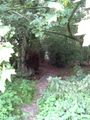
The expedition was easy and routine. I parked by the church and walked a few hundred metres to the hashpoint which was right on a public footpath. Geohashing in this part of the world can be really easy. Every week or so there seems to be a hashpoint on or very near a public path. History has left us with so many public paths. It's great.
Today was a day of jelly-sky (Jell-O-sky). While standing still the GPSr seemed to be wandering about over a +/- 5 metre radius. There were big cumulus convection clouds making the satellites wobble.
MagicIan lives within a 10 minute walk of the hashpoint, so had an even easier time to get there. He got back from work, had dinner and then went for an lovely sunny summer evening stroll, doing a circular route which he had done as part of a longer hike sometime in the past. His route crossed Mulbarton, down the side of some houses and across the horse field to get onto the Tas Valley Way. Once photos at the hashpoint were completed he carried on and returned by way of the road.
Achievements
Sourcerer earned the Earliest geohasher achievement
|
MagicIan earned the Walk geohash Achievement
|
Photos
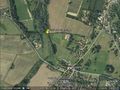
Google Earth Track
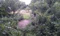
The Hashpoint
The Hashpoint
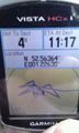
The Evidence
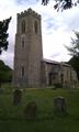
Mulbarton Church
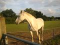
A friendly horse on the way to the hashpoint
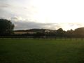
View across the fields
Marker left at the hashpoint

MagicIan at the hashpoint
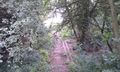
The Tas Valley Way on the return journey
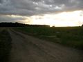
Sunset on the return journey
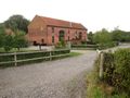
Ash Hall Barn on the return journey


Expeditions and Plans
| 2011-08-16 | ||
|---|---|---|
| Hartford, Connecticut | Someone went | Somewhere |
| Zürich, Switzerland | Crox, Elisa | Böttstein, Switzerland |
| Stuttgart, Germany | Ekorren, Steingesicht | Mittelstadt, near Reutlingen. A place near the main road, a small public gr... |
| Vancouver, British Columbia | Someone went | Someplace inaccessible |
| Norwich, United Kingdom | Sourcerer, MagicIan | On the Tas Valley Way, 400 metres north west of Mulbarton and 8.5 km south ... |
Sourcerer's Expedition Links
2011-08-03 52 1 - 2011-08-16 52 1 - 2011-08-22 52 -0 - KML file download of Sourcerer's expeditions for use with Google Earth.