Difference between revisions of "2011-09-19 44 -121"
imported>Michael5000 m |
imported>FippeBot m (Location) |
||
| (11 intermediate revisions by one other user not shown) | |||
| Line 5: | Line 5: | ||
}} | }} | ||
| − | [[File:2011-09-19 44 -121 main.JPG|thumb| | + | [[File:2011-09-19 44 -121 main.JPG|thumb|left|200 px|It's a tree!]] |
| Line 11: | Line 11: | ||
== Location == | == Location == | ||
| − | + | In Crooked River Ranch, an ultra-low density development northwest of Terrebonne. | |
== Participants == | == Participants == | ||
| Line 20: | Line 20: | ||
== Expedition == | == Expedition == | ||
| + | I had now chased 44.4223289 N latitude 250 miles westward, passing through the towns of Prineville and Terrebonne since an adventure in the forest an hour earlier. With the sun coming in at a golden slant, I entered an area called, I believe, "Crooked River Ranch." I don't know what the exact land-development concept is, but on the ground it has the look of an ordinary residential neighborhood, except that every house has a lot the size of a large farm field. There is a rectangular street grid, but the streets are maybe seven or eight times as far apart as in ordinary neighborhoods. It seemed like just about the least efficient way you could possibly use land, but no doubt there's some kind of logic behind it. | ||
| + | |||
| + | The hashpoint was near a street on a (huge) vacant lot, so there wasn't much more to this one than driving out to it, taking a picture of the nicely-lit tree at the hashpoint, and driving back out to the highway. Expedition Success. | ||
== Photos == | == Photos == | ||
| − | |||
| − | |||
| − | |||
<gallery perrow="5"> | <gallery perrow="5"> | ||
| + | File:2011-09-19 44 -121 main.JPG|It is a tree, which is more or less at the hashpoint! | ||
| + | File:2011-09-19 44 -121 (4).JPG|It is the truck, on the road very near the hashpoint! | ||
| + | File:2011-09-19 44 -121 (3).JPG|I was there! | ||
| + | File:2011-09-19 44 -121.JPG|Here is a picture of a street intersection nearby, lest you doubt me! | ||
</gallery> | </gallery> | ||
| Line 32: | Line 36: | ||
{{#vardefine:ribbonwidth|800px}} | {{#vardefine:ribbonwidth|800px}} | ||
<!-- Add any achievement ribbons you earned below, or remove this section --> | <!-- Add any achievement ribbons you earned below, or remove this section --> | ||
| + | {{Multihash2 | count = 4 | date = 2011-09-19 | name = [[User:Michael5000|Michael5000]]}} | ||
| + | * Six attempts and four successes in one long day. | ||
| + | |||
| + | *Eleventh Expedition of the [[Endurance Geohashing]] series. | ||
| + | *First Expedition (by me) to the Bend graticule. | ||
| + | *First Expedition to Jefferson County. | ||
| + | |||
| + | {{Minesweeper geohash | ||
| + | | graticule = [[Portland, Oregon]] | ||
| + | | ranknumber = 7 | ||
| + | | ne = true if graticule to the northeast has been hashed (optional) | ||
| + | | e = true if graticule to the east has been hashed (optional) | ||
| + | | se = true if graticule to the southeast has been hashed (optional) | ||
| + | | s = true if graticule to the south has been hashed (optional) | ||
| + | | sw = true if graticule to the southwest has been hashed (optional) | ||
| + | | w = true if graticule to the west has been hashed (optional) | ||
| + | | nw = true if graticule to the northwest has been hashed (optional) | ||
| + | | name = [[User:Michael5000|Michael5000]] | ||
| + | }} | ||
| + | {{Minesweeper geohash | ||
| + | | graticule = [[Springfield, Oregon]] | ||
| + | | ranknumber = 5 | ||
| + | | n = true | ||
| + | | ne = true | ||
| + | | e = true | ||
| + | | nw = true | ||
| + | | w = true | ||
| + | | name = [[User:Michael5000|Michael5000]] | ||
| + | }} | ||
| + | |||
| + | {{Minesweeper geohash | ||
| + | | graticule = [[The Dalles, Oregon]] | ||
| + | | ranknumber = 5 | ||
| + | | n = true | ||
| + | | se = true | ||
| + | | s = true | ||
| + | | sw = true | ||
| + | | w = true | ||
| + | | name = [[User:Michael5000|Michael5000]] | ||
| + | }} | ||
| − | |||
| − | |||
| − | |||
| − | |||
| − | |||
| − | |||
[[Category:Expeditions]] | [[Category:Expeditions]] | ||
| − | |||
[[Category:Expeditions with photos]] | [[Category:Expeditions with photos]] | ||
| − | |||
| − | |||
| − | |||
| − | |||
| − | |||
[[Category:Coordinates reached]] | [[Category:Coordinates reached]] | ||
| − | + | {{location|US|OR|JE}} | |
| − | |||
| − | |||
| − | |||
| − | |||
| − | |||
| − | |||
| − | |||
| − | |||
| − | |||
Latest revision as of 00:55, 13 August 2019
| Mon 19 Sep 2011 in 44,-121: 44.4223289, -121.2688817 geohashing.info google osm bing/os kml crox |

Location
In Crooked River Ranch, an ultra-low density development northwest of Terrebonne.
Participants
Expedition
I had now chased 44.4223289 N latitude 250 miles westward, passing through the towns of Prineville and Terrebonne since an adventure in the forest an hour earlier. With the sun coming in at a golden slant, I entered an area called, I believe, "Crooked River Ranch." I don't know what the exact land-development concept is, but on the ground it has the look of an ordinary residential neighborhood, except that every house has a lot the size of a large farm field. There is a rectangular street grid, but the streets are maybe seven or eight times as far apart as in ordinary neighborhoods. It seemed like just about the least efficient way you could possibly use land, but no doubt there's some kind of logic behind it.
The hashpoint was near a street on a (huge) vacant lot, so there wasn't much more to this one than driving out to it, taking a picture of the nicely-lit tree at the hashpoint, and driving back out to the highway. Expedition Success.
Photos
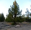
It is a tree, which is more or less at the hashpoint!
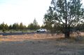
It is the truck, on the road very near the hashpoint!
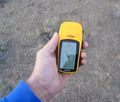
I was there!
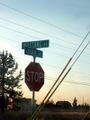
Here is a picture of a street intersection nearby, lest you doubt me!
.JPG)
.JPG)

Achievements
Michael5000 earned the Multihash Achievement
|
- Six attempts and four successes in one long day.
- Eleventh Expedition of the Endurance Geohashing series.
- First Expedition (by me) to the Bend graticule.
- First Expedition to Jefferson County.
Michael5000 achieved level 7 of the Minesweeper Geohash achievement
|
Michael5000 achieved level 5 of the Minesweeper Geohash achievement
|
Michael5000 achieved level 5 of the Minesweeper Geohash achievement
|