Difference between revisions of "2012-08-10 -35 149"
imported>1PE (Created page with "{{subst:Expedition |lat = latitude of graticule |lon = longitude of graticule |date = date of expedition, in YYYY-MM-DD format }}") |
m (More specific location) |
||
| (9 intermediate revisions by 3 users not shown) | |||
| Line 1: | Line 1: | ||
| + | [[Image:{{{image|2012-08-10 -35 149 dam.JPG}}}|thumb|left]] | ||
| − | + | {{meetup graticule | lat=-35| lon=149| date=2012-08-10}} | |
| − | |||
| − | |||
| − | |||
| − | |||
| − | |||
| − | |||
| − | |||
| − | |||
| − | {{meetup graticule | ||
| − | | lat= | ||
| − | | lon= | ||
| − | | date= | ||
| − | }} | ||
<!-- edit as necessary --> | <!-- edit as necessary --> | ||
__NOTOC__ | __NOTOC__ | ||
== Location == | == Location == | ||
| − | + | In a paddock off the Tarago-Collector Road, near the Tarago-Bungendore Road, Tarago, NSW. | |
== Participants == | == Participants == | ||
| − | + | [[User:1PE|1PE]] | |
| − | |||
== Plans == | == Plans == | ||
| − | + | ===[[User:1PE|1PE]]=== | |
| + | I thought about the ~90 minute excursion over lunch-time. I had to stay back at work in the evening, anyway...... | ||
== Expedition == | == Expedition == | ||
| − | + | ===[[User:1PE|1PE]]=== | |
| + | The trip was to a hash point ~45km "as the crow flies", and ~55km by road, along mostly country roads with 100km/h signage. From Queanbeyan, I took the road to Bungendore, then straight through towards Tarago. On this road I passed two of my recent hashes ([[2012-08-01 -35 149]] and [[2012-08-01 -35 149]]) that were not able to be reached due to access issues. The turn-off from the Bungendore-Tarago Road onto the Tarago-Collector Road was interesting, and gave me the first idea of what was coming; the corner was recently rebuilt and re-tarred, and there was a large truck stopped waiting for me to turn. (This was "the middle of nowhere"....) | ||
| − | + | I had observed that the property had a farm house a little past the hash, and decided to go there first to seek permission. As I drove up, I saw a person inside the house, so knocked and stepped well back so she would not feel threatened. I explained what I wanted to do; walk in from the road. The woman told me that the property was owned by a company operating the adjacent waste processing facility, and that I needed to go there to seek permission. | |
| − | + | ||
| + | Three kilometers down the road is the site office for the [http://www.veoliaes.com.au/recycling-services/resource-recovery-facilities/bioreactor-landfills Woodlawn Bioreactor], the world's largest purpose-built site for processing and recovering energy from landfill. | ||
| + | |||
| + | I was put in a large room with a video of the site and waste processing for about 10 minutes, while I waited for the manager to be free to see me. | ||
| + | |||
| + | Veolia bought the former copper/lead/zinc open-cut mine (Woodlawn) with is gradually filling it with trash and general waste from [[Sydney, Australia|Sydney]] (about 250km away) at the rate of about 8,000 tonnes a week. It is packaged in 40ft shipping containers and then off-loaded at Tarago and trucked in to the site some 10km away. The capped waste gradually decays, giving off water and methane. [http://www.veolia.com.au Veolia Environment Services] is capturing the methane (a particularly bad greenhouse gas) to burn it and create 'green' electricity. The former tailings dams will be rehabilitated with processed "green waste". The area is an "ecological farm" complex including processing of the waste water through a fish farm, and then a hydroponics facility for cleaning the water. Surrounding rural farms, such as where the hash is sited, have been purchased to further the 'green' farm zone. The adjacent hills also have the Capital Wind Farm. | ||
| + | |||
| + | The manager arrived just as the video ended, understood geohashing after my explanation, knew the area where the hash is (beyond the dam), but said that Workplace Health and Safety laws meant that he could ''not'' authorise access. | ||
| + | |||
| + | I said that I would get some pictures from the road, urged him to take a copy of the [http://activegeohasher.com/geohash/2012-08-10/-35/149 activegeohasher.com print-out] and look for this page next week, said I'd drop the original in to the farmhouse, and then left. | ||
| + | |||
| + | The woman at the farmhouse thanked me for the details. | ||
| + | |||
| + | The grass by the road had grown very thick from the recent rains, but I reached the raised bank beside the road and the fence near the farm dam that has the hash site beyond it, as the pictures show. | ||
== Photos == | == Photos == | ||
| − | |||
| − | |||
| − | |||
<gallery perrow="5"> | <gallery perrow="5"> | ||
| + | file:2012-06-10 -35 149 field.JPG|"Old Veolia had a farm...." | ||
| + | file:2012-08-10 -35 149 dam.JPG|Dam(n), the farm is looking good. | ||
| + | file:2012-08-10 -35 149 biomass.JPG|The Woodlawn open-cut mine, now bio-mass greenhouse gas conversion facility. | ||
</gallery> | </gallery> | ||
== Achievements == | == Achievements == | ||
{{#vardefine:ribbonwidth|800px}} | {{#vardefine:ribbonwidth|800px}} | ||
| − | + | None likely. | |
| − | + | :''The [[no trespassing consolation prize]] is available should you want it. If you collect 100 of them you get to trade them for a [[Posted achievement]]!'' :-) — <span style="text-shadow:grey 0.2em 0.2em 0.1em; class=texhtml">[[User:Benjw|Benjw]]</span> <sub>{[[User talk:Benjw|talk]]}</sub> 11:46, 1 September 2012 (EDT) | |
| − | |||
| − | |||
| − | |||
| − | [[ | ||
| − | |||
| − | < | ||
| − | < | ||
| − | [[ | ||
| − | |||
| − | |||
[[Category:Expeditions]] | [[Category:Expeditions]] | ||
| − | |||
[[Category:Expeditions with photos]] | [[Category:Expeditions with photos]] | ||
| − | |||
| − | |||
| − | |||
| − | |||
| − | |||
| − | |||
| − | |||
| − | |||
| − | |||
[[Category:Coordinates not reached]] | [[Category:Coordinates not reached]] | ||
| − | |||
| − | |||
| − | |||
| − | |||
| − | |||
[[Category:Not reached - No public access]] | [[Category:Not reached - No public access]] | ||
| − | + | {{location|AU|NSW|GB}} | |
| − | |||
| − | |||
| − | |||
| − | |||
| − | |||
| − | |||
| − | |||
Latest revision as of 12:20, 1 August 2020

| Fri 10 Aug 2012 in -35,149: -35.0898871, 149.6078613 geohashing.info google osm bing/os kml crox |
Location
In a paddock off the Tarago-Collector Road, near the Tarago-Bungendore Road, Tarago, NSW.
Participants
Plans
1PE
I thought about the ~90 minute excursion over lunch-time. I had to stay back at work in the evening, anyway......
Expedition
1PE
The trip was to a hash point ~45km "as the crow flies", and ~55km by road, along mostly country roads with 100km/h signage. From Queanbeyan, I took the road to Bungendore, then straight through towards Tarago. On this road I passed two of my recent hashes (2012-08-01 -35 149 and 2012-08-01 -35 149) that were not able to be reached due to access issues. The turn-off from the Bungendore-Tarago Road onto the Tarago-Collector Road was interesting, and gave me the first idea of what was coming; the corner was recently rebuilt and re-tarred, and there was a large truck stopped waiting for me to turn. (This was "the middle of nowhere"....)
I had observed that the property had a farm house a little past the hash, and decided to go there first to seek permission. As I drove up, I saw a person inside the house, so knocked and stepped well back so she would not feel threatened. I explained what I wanted to do; walk in from the road. The woman told me that the property was owned by a company operating the adjacent waste processing facility, and that I needed to go there to seek permission.
Three kilometers down the road is the site office for the Woodlawn Bioreactor, the world's largest purpose-built site for processing and recovering energy from landfill.
I was put in a large room with a video of the site and waste processing for about 10 minutes, while I waited for the manager to be free to see me.
Veolia bought the former copper/lead/zinc open-cut mine (Woodlawn) with is gradually filling it with trash and general waste from Sydney (about 250km away) at the rate of about 8,000 tonnes a week. It is packaged in 40ft shipping containers and then off-loaded at Tarago and trucked in to the site some 10km away. The capped waste gradually decays, giving off water and methane. Veolia Environment Services is capturing the methane (a particularly bad greenhouse gas) to burn it and create 'green' electricity. The former tailings dams will be rehabilitated with processed "green waste". The area is an "ecological farm" complex including processing of the waste water through a fish farm, and then a hydroponics facility for cleaning the water. Surrounding rural farms, such as where the hash is sited, have been purchased to further the 'green' farm zone. The adjacent hills also have the Capital Wind Farm.
The manager arrived just as the video ended, understood geohashing after my explanation, knew the area where the hash is (beyond the dam), but said that Workplace Health and Safety laws meant that he could not authorise access.
I said that I would get some pictures from the road, urged him to take a copy of the activegeohasher.com print-out and look for this page next week, said I'd drop the original in to the farmhouse, and then left.
The woman at the farmhouse thanked me for the details.
The grass by the road had grown very thick from the recent rains, but I reached the raised bank beside the road and the fence near the farm dam that has the hash site beyond it, as the pictures show.
Photos
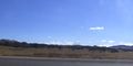
"Old Veolia had a farm...."
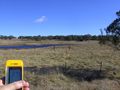
Dam(n), the farm is looking good.
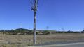
The Woodlawn open-cut mine, now bio-mass greenhouse gas conversion facility.


Achievements
None likely.
- The no trespassing consolation prize is available should you want it. If you collect 100 of them you get to trade them for a Posted achievement! :-) — Benjw {talk} 11:46, 1 September 2012 (EDT)