Difference between revisions of "2012-08-10 56 -3"
From Geohashing
imported>Sourcerer ([live] Arrived.) |
imported>FippeBot m (Location) |
||
| (13 intermediate revisions by one other user not shown) | |||
| Line 1: | Line 1: | ||
| − | |||
| − | |||
| − | |||
| − | |||
| − | |||
| − | |||
| − | |||
| − | |||
| − | |||
| − | |||
{{meetup graticule | {{meetup graticule | ||
| − | | lat=56 | + | | lat=56 |
| − | | lon=-3 | + | | lon=-3 |
| − | | date=2012-08-10 | + | | date=2012-08-10 |
| + | | graticule_name=Perth, UK | ||
| + | | graticule_link=Perth, United Kingdom | ||
}} | }} | ||
| − | |||
| − | |||
== Location == | == Location == | ||
| − | + | ||
| + | Just south of the A907, west of Dunfirmline, Scotland, UK. This was [[User:Sourcerer|Sourcerer's]] one hundredth expedition. | ||
== Participants == | == Participants == | ||
| − | |||
| − | |||
| − | + | [[User:Sourcerer|Sourcerer]] | |
| − | |||
== Expedition == | == Expedition == | ||
| − | |||
| + | *Arrived. -- [[User:Sourcerer|Sourcerer]] [http://www.openstreetmap.org/?lat=56.0665735&lon=-3.6328243&zoom=16&layers=B000FTF @56.0666,-3.6328] 10:06, 10 August 2012 (GMT+01:00) | ||
| − | + | This was not my favourite kind of expedition. Drive on busy roads for ages to stand in a damp wheat field. I would not have bothered except this was a new graticule and I might never get to Scotland again in my lifetime. It's 1000 km away so not really ideal for a day trip. I'm in Scotland for the wedding of some good friends and making the best of the few days I'm staying. | |
| − | |||
| − | |||
== Photos == | == Photos == | ||
| − | < | + | |
| − | Image: | + | <gallery> |
| − | -- | + | Image:2012-08-10 56 -3 Sourcerer 1.jpg|Google Earth Overview |
| − | + | Image:2012-08-10 56 -3 Sourcerer 2.jpg|The Terrain | |
</gallery> | </gallery> | ||
== Achievements == | == Achievements == | ||
| − | {{#vardefine:ribbonwidth| | + | {{#vardefine:ribbonwidth|700px}} |
| − | + | {{consecutive geohash | |
| + | | count = 3 | ||
| + | | latitude = 52 | ||
| + | | longitude = 0 | ||
| + | | date = 2012-08-08 | ||
| + | | name = Sourcerer | ||
| + | }} | ||
| + | {{Two to the N achievement | ||
| + | | count = 6.64385618977472 | ||
| + | | latitude = 52 | ||
| + | | longitude = 0 | ||
| + | | date = 2012-08-08 | ||
| + | | name = Sourcerer | ||
| + | }} | ||
| + | {{Sourcerer_links | ||
| + | | prev = 2012-08-09 56 -2 | ||
| + | | curr = 2012-08-10 56 -3 | ||
| + | | next = 2012-08-16 52 1 | ||
| + | | date = 2012-08-10 | ||
| + | }} | ||
| − | |||
| − | |||
| − | |||
| − | |||
| − | |||
| − | |||
| − | |||
| − | |||
| − | |||
| − | |||
[[Category:Expeditions]] | [[Category:Expeditions]] | ||
| − | |||
[[Category:Expeditions with photos]] | [[Category:Expeditions with photos]] | ||
| − | |||
| − | |||
| − | |||
| − | |||
| − | |||
[[Category:Coordinates reached]] | [[Category:Coordinates reached]] | ||
| − | + | {{location|GB|SCT|FIF}} | |
| − | |||
| − | |||
| − | |||
| − | |||
| − | |||
| − | |||
| − | |||
| − | |||
| − | |||
| − | |||
| − | |||
| − | |||
| − | |||
| − | |||
| − | |||
| − | |||
| − | |||
Latest revision as of 05:30, 13 August 2019
| Fri 10 Aug 2012 in Perth, UK: 56.0898871, -3.6078613 geohashing.info google osm bing/os kml crox |
Contents
Location
Just south of the A907, west of Dunfirmline, Scotland, UK. This was Sourcerer's one hundredth expedition.
Participants
Expedition
- Arrived. -- Sourcerer @56.0666,-3.6328 10:06, 10 August 2012 (GMT+01:00)
This was not my favourite kind of expedition. Drive on busy roads for ages to stand in a damp wheat field. I would not have bothered except this was a new graticule and I might never get to Scotland again in my lifetime. It's 1000 km away so not really ideal for a day trip. I'm in Scotland for the wedding of some good friends and making the best of the few days I'm staying.
Photos
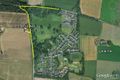
Google Earth Overview
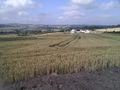
The Terrain


Achievements
Sourcerer earned the Consecutive geohash achievement
|

Sourcerer earned the Two to the N achievement
by attempting to reach 26.64385618977472 hashpoints on 2012-08-08 52 0 and is promoted to Level 6.64385618977472 (Expeditions).
Expeditions and Plans
| 2012-08-10 | ||
|---|---|---|
| Canberra, Australia | 1PE | In a paddock off the Tarago-Collector Road, near the Tarago-Bungendore Road... |
| San Diego, California | JesseW, Todd (Mathgeek), LucasBrown | In front of 2854 Luna Avenue, San Diego. |
| Aurora, Illinois | Haberdasher | in Fermilab, in between two lakes. |
| Seattle, Washington | Thomcat | Just west of North Creek Park, a wetland with 3/4 mile of floating walkways... |
| Emden, Germany | Frizzy, Hijackal | In a field south of Ostrhauderfehn |
| Carlisle, United Kingdom | Someone went | Near Wray, 8.6 miles from Angel's home according to Geohash Droid. Looks li... |
| Perth, United Kingdom | Sourcerer | Just south of the A907, west of Dunfirmline, Scotland, UK. This was Sourcerer's... |
Sourcerer's Expedition Links
2012-08-09 56 -2 - 2012-08-10 56 -3 - 2012-08-16 52 1 - KML file download of Sourcerer's expeditions for use with Google Earth.