Difference between revisions of "2013-02-19 52 1"
From Geohashing
imported>Sourcerer (→Sourcerer Reached his 100th Hashpoint) |
imported>FippeBot m (Location) |
||
| (5 intermediate revisions by one other user not shown) | |||
| Line 27: | Line 27: | ||
<gallery perrow="5"> | <gallery perrow="5"> | ||
Image:2013-02-19_52_1_Sourcerer.jpg|The Hashpoint | Image:2013-02-19_52_1_Sourcerer.jpg|The Hashpoint | ||
| + | Image:2013-02-19 52 1 Sourcerer Track.jpg|Track in Google Earth | ||
</gallery> | </gallery> | ||
| Line 33: | Line 34: | ||
{{#vardefine:ribbonwidth|700px}} | {{#vardefine:ribbonwidth|700px}} | ||
| + | In fact it was four hashpoints in two days. The triple hash was on Monday. | ||
| + | |||
| + | {{Two to the N achievement | ||
| + | | count = 6.64385618977472 | ||
| + | | latitude = 52 | ||
| + | | longitude = 1 | ||
| + | | date = 2013-02-19 | ||
| + | | name = Sourcerer | ||
| + | | reached = true | ||
| + | }} | ||
{{consecutive geohash | {{consecutive geohash | ||
| count = 2 | | count = 2 | ||
| Line 41: | Line 52: | ||
}} | }} | ||
| − | + | {{Sourcerer_links | |
| − | + | | prev = 2013-02-18 52 1 | |
| − | {{ | + | | curr = 2013-02-19 52 1 |
| − | + | | next = 2013-03-07 52 1 | |
| − | + | | date = 2013-02-19 | |
| − | + | }} | |
| − | |||
| − | |||
| − | |||
| − | |||
| − | |||
| − | |||
| − | |||
| − | |||
[[Category:Expeditions]] | [[Category:Expeditions]] | ||
[[Category:Expeditions with photos]] | [[Category:Expeditions with photos]] | ||
[[Category:Coordinates reached]] | [[Category:Coordinates reached]] | ||
| + | {{location|GB|ENG|SFK}} | ||
Latest revision as of 01:02, 14 August 2019
| Tue 19 Feb 2013 in Norwich: 52.4429599, 1.4515522 geohashing.info google osm bing/os kml crox |
Contents
Location
In a field just south of Bungay, Suffolk, UK.
Participants
Expedition
- Arrived. -- Sourcerer @52.4430,1.4513 09:37, 19 February 2013 (GMT)
This was my 100th successful expedition!
In other respects it was quite mundane. On a shopping tour via some farms selling local produce, a small diversion south, lead to the hashpoint. I got to within 16 metres on a lane leading to a private drive. Reaching the actual point required a small backtrack and a short walk along a field boundary on the correct side of the well maintained hedge. The hashpoint was a few paces from the field boundary.
Photos
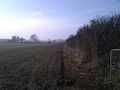
The Hashpoint
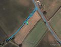
Track in Google Earth


Achievements
In fact it was four hashpoints in two days. The triple hash was on Monday.

Sourcerer earned the Two to the N achievement
by reaching 26.64385618977472 hashpoints on 2013-02-19 52 1 and is promoted to Level 6.64385618977472 (Coordinates reached).
Sourcerer earned the Consecutive geohash achievement
|
Expeditions and Plans
| 2013-02-19 | ||
|---|---|---|
| Lafayette, Indiana | Buttercup, Buttercup's brother | Just north of Purdue University's campus on the side of the road. |
| Portland, Oregon | Jim | On farmland south of Hillsboro |
| Zürich, Switzerland | Calamus, Guga2112 | A field near Regensdorf. |
| London West, United Kingdom | KennethCC, Dnfrd | Part-way along Clockhouse lane, Ashford, in Middlesex; in the verge by the ... |
| Norwich, United Kingdom | Sourcerer | In a field just south of Bungay, Suffolk, UK. |
Sourcerer's Expedition Links
2013-02-18 52 1 - 2013-02-19 52 1 - 2013-03-07 52 1 - KML file download of Sourcerer's expeditions for use with Google Earth.