Difference between revisions of "2014-09-10 52 1"
imported>Sourcerer m ([live picture] Evidence [http://www.openstreetmap.org/?lat=52.34490216&lon=1.14133358&zoom=16&layers=B000FTF @52.3449,1.1413]) |
imported>FippeBot m (Location) |
||
| (9 intermediate revisions by one other user not shown) | |||
| Line 1: | Line 1: | ||
| − | |||
| − | |||
| − | |||
| − | |||
| − | |||
| − | |||
| − | |||
| − | |||
| − | |||
| − | |||
{{meetup graticule | {{meetup graticule | ||
| − | | lat=52 | + | | lat=52 |
| − | | lon=1 | + | | lon=1 |
| − | | date=2014-09-10 | + | | date=2014-09-10 |
| + | | graticule_name=Norwich, UK | ||
| + | | graticule_link=Norwich, United Kingdom | ||
}} | }} | ||
| − | |||
| − | |||
__NOTOC__ | __NOTOC__ | ||
== Location == | == Location == | ||
| − | + | ||
| + | On Rectory Road between Brome and Brome Street south of Diss, Suffolk, UK. | ||
== Participants == | == Participants == | ||
| − | |||
| − | |||
| − | + | [[User:Sourcerer|Sourcerer]] | |
| − | |||
== Expedition == | == Expedition == | ||
| − | |||
| + | === Original === | ||
*Arrived. -- [[User:Sourcerer|Sourcerer]] ([[User talk:Sourcerer|talk]]) [http://www.openstreetmap.org/?lat=52.34490752&lon=1.14132285&zoom=16&layers=B000FTF @52.3449,1.1413] 15:56, 10 September 2014 (EDT) | *Arrived. -- [[User:Sourcerer|Sourcerer]] ([[User talk:Sourcerer|talk]]) [http://www.openstreetmap.org/?lat=52.34490752&lon=1.14132285&zoom=16&layers=B000FTF @52.3449,1.1413] 15:56, 10 September 2014 (EDT) | ||
| − | == | + | |
| − | + | Setting out after dark, the drive to the hashpoint was easy, arriving at about 9pm. It must have been a good year for hedgehogs. They are rarely seen but tonight was more like a slalom course, weaving around the beasties crossing the roads. Two hares were spotted and possibly a muntjac deer with rather wonderful silvery eyes reflecting the headlights. The hashpoint was right on the road and of little interest but the journey was really nice. Heading east on the way home, an almost full, waning moon was very bright in the sky. | |
| + | |||
| + | === Retro on 2015-12-18 01:22 === | ||
| + | |||
| + | *Retro arrival. -- [[User:Sourcerer|Sourcerer]] ([[User talk:Sourcerer|talk]]) [http://www.openstreetmap.org/?lat=52.34492362&lon=1.14138186&zoom=16&layers=B000FTF @52.3449,1.1414] 01:22, 18 December 2015 (GMT) | ||
| + | |||
| + | Expedition four of five spanning midnight. This retro point was on my route home. | ||
| + | |||
| + | [[2015-12-17 52 0]] - [[2015-12-18 52 0]] - [[2015-01-15 52 0|2015-01-15 52 0 Retro]] - [[2014-09-10 52 1|2014-09-10 52 1 Retro]] - [[2015-09-27 52 1|2015-09-27 52 1 Retro]] | ||
== Photos == | == Photos == | ||
| − | + | ||
| − | |||
| − | |||
<gallery perrow="5"> | <gallery perrow="5"> | ||
| − | + | Image:2014-09-10_52_1_20-58-12-267.jpg | Original Evidence [http://www.openstreetmap.org/?lat=52.34490216&lon=1.14133358&zoom=16&layers=B000FTF @52.3449,1.1413] | |
| − | Image:2014-09-10_52_1_20-58-12-267.jpg | Evidence [http://www.openstreetmap.org/?lat=52.34490216&lon=1.14133358&zoom=16&layers=B000FTF @52.3449,1.1413] | + | Image:2014-09-10_52_1_Sourcerer_1450401605545.jpg | Retro proof. [http://www.openstreetmap.org/?lat=52.34492362&lon=1.14138186&zoom=16&layers=B000FTF @52.3449,1.1414] |
| + | Image:2014-09-10 52 1 Sourcerer Retro.jpg | Google Earth Retro Track | ||
</gallery> | </gallery> | ||
== Achievements == | == Achievements == | ||
| − | |||
| − | |||
| + | {{Sourcerer_links | ||
| + | | prev = 2014-08-19 52 0 | ||
| + | | curr = 2014-09-10 52 1 | ||
| + | | next = 2014-09-18 52 1 | ||
| + | | date = 2014-09-10 | ||
| + | }} | ||
| − | |||
| − | |||
| − | |||
| − | |||
| − | |||
| − | |||
| − | |||
| − | |||
| − | |||
| − | |||
| − | |||
| − | |||
[[Category:Expeditions]] | [[Category:Expeditions]] | ||
| − | |||
[[Category:Expeditions with photos]] | [[Category:Expeditions with photos]] | ||
| − | |||
| − | |||
| − | |||
| − | |||
| − | |||
[[Category:Coordinates reached]] | [[Category:Coordinates reached]] | ||
| − | + | [[Category:Retro meetup]] | |
| − | + | [[Category:Retro coordinates reached]] | |
| − | + | {{location|GB|ENG|SFK}} | |
| − | |||
| − | |||
| − | |||
| − | |||
| − | |||
| − | |||
| − | [[Category: | ||
| − | |||
| − | |||
| − | [[Category: | ||
| − | |||
| − | |||
| − | |||
| − | |||
| − | |||
Latest revision as of 01:22, 15 August 2019
| Wed 10 Sep 2014 in Norwich, UK: 52.3448823, 1.1413950 geohashing.info google osm bing/os kml crox |
Location
On Rectory Road between Brome and Brome Street south of Diss, Suffolk, UK.
Participants
Expedition
Original
- Arrived. -- Sourcerer (talk) @52.3449,1.1413 15:56, 10 September 2014 (EDT)
Setting out after dark, the drive to the hashpoint was easy, arriving at about 9pm. It must have been a good year for hedgehogs. They are rarely seen but tonight was more like a slalom course, weaving around the beasties crossing the roads. Two hares were spotted and possibly a muntjac deer with rather wonderful silvery eyes reflecting the headlights. The hashpoint was right on the road and of little interest but the journey was really nice. Heading east on the way home, an almost full, waning moon was very bright in the sky.
Retro on 2015-12-18 01:22
- Retro arrival. -- Sourcerer (talk) @52.3449,1.1414 01:22, 18 December 2015 (GMT)
Expedition four of five spanning midnight. This retro point was on my route home.
2015-12-17 52 0 - 2015-12-18 52 0 - 2015-01-15 52 0 Retro - 2014-09-10 52 1 Retro - 2015-09-27 52 1 Retro
Photos
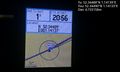
Original Evidence @52.3449,1.1413
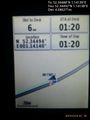
Retro proof. @52.3449,1.1414
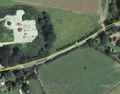
Google Earth Retro Track


Achievements
Expeditions and Plans
| 2014-09-10 | ||
|---|---|---|
| Canberra, Australia | 1PE | On the gas pipe easement beside Hindmarsh Drive, Red Hill. Very close t... |
| Denton, Texas | WalkerBR | In a private road on Corinth, TX. |
| Wien, Austria | Patrizius, B2c | was located west of Vienna in the Tullner Au, which turned out to be in a r... |
| Kassel, Germany | GeorgDerReisende | The hash lay under a tree on a meadow of Wolfhagen. |
| Norwich, United Kingdom | Sourcerer | On Rectory Road between Brome and Brome Street south of Diss, Suffolk, UK. |
| Utrecht, Netherlands | Tchakkazulu | Near the Almere Poort train station. |
Sourcerer's Expedition Links
2014-08-19 52 0 - 2014-09-10 52 1 - 2014-09-18 52 1 - KML file download of Sourcerer's expeditions for use with Google Earth.