Difference between revisions of "2015-01-22 52 1"
imported>Sourcerer (An expedition message sent via Geohash Droid for Android.) |
imported>FippeBot m (Location) |
||
| (13 intermediate revisions by one other user not shown) | |||
| Line 1: | Line 1: | ||
| − | |||
| − | |||
| − | |||
| − | |||
| − | |||
| − | |||
| − | |||
| − | |||
| − | |||
| − | |||
{{meetup graticule | {{meetup graticule | ||
| lat=52 | | lat=52 | ||
| lon=1 | | lon=1 | ||
| date=2015-01-22 | | date=2015-01-22 | ||
| + | | graticule_name=Norwich, UK | ||
| + | | graticule_link=Norwich, United Kingdom | ||
}} | }} | ||
| − | |||
| − | |||
__NOTOC__ | __NOTOC__ | ||
== Location == | == Location == | ||
| − | + | ||
| + | Beside a pool between Ilketshall Saint Margaret and Saint James South Elmham, Suffolk, UK. | ||
== Participants == | == Participants == | ||
| − | |||
| − | |||
| − | + | * [[User:Sourcerer|Sourcerer]] | |
| − | + | * [[User:Sourcerer|Sourcerer]] re-visited this hashpoint on 2015-02-24 | |
== Expedition == | == Expedition == | ||
| − | |||
| − | == | + | *Arrived. -- [[User:Sourcerer|Sourcerer]] ([[User talk:Sourcerer|talk]]) [http://www.openstreetmap.org/?lat=52.38950193&lon=1.41258538&zoom=16&layers=B000FTF @52.3895,1.4126] 16:36, 22 January 2015 (GMT) |
| − | + | ||
| + | The Hash Fairy has been on a roll for the last few weeks, providing easily reached points in eastern England. On Monday I reached six points in one day. Tuesday and Wednesday were good candidates but sadly I was busy with work related matters. Today the hashpoint was 12 km from my home and 15 metres from a public footpath. That is about as easy as it gets. | ||
| + | |||
| + | There was concrete hard standing for loading sugar beet onto lorries. This made an ideal dry car parking place. The public footpath was opposite the car park and it was dry and in perfect condition. The hashpoint was about 600 metres down the path. | ||
| + | |||
| + | With about 15 metres to go, I was on the wrong side of a fence. There was quite a large pool of inky black water. Would the hashpoint require a quick January 3 Celsuis dip? | ||
| + | |||
| + | I backtracked and found a way into the next field. The Hash Fairy came up trumps with the point on the dry banks of the pool. The sight conjured up images from "Lord of the Rings". The air was completely still and the inky black water was reflecting the trees just like a mirror. Sadly no hobbits or dwarves were in evidence. | ||
| + | |||
| + | Having had time, more carefully to review the photo, I'm almost sure there's an Ent photobombing the image. | ||
| + | |||
| + | In fading light, I took a selfie and temporarily blinded myself. Drat! | ||
| + | |||
| + | Finally I set off home leaving Mirrormere behind. On the drive home, I passed a sign towards "Eel's Foot". This led down an alternative footpath to the hashpoint. Perhaps this is the correct name for the pool. | ||
| + | |||
| + | == Retro-Hash == | ||
| + | |||
| + | [[User:Sourcerer|Sourcerer]] re-visited this hashpoint on 2015-02-24 because he had 5 minutes to kill and it was only 80 metres from the [[2015-02-25 52 1]] point. This allowed an exact midnight arrival at [[2015-02-25 52 1]]. The ent had gone! | ||
== Photos == | == Photos == | ||
| − | + | ||
| − | |||
| − | |||
<gallery perrow="5"> | <gallery perrow="5"> | ||
| + | Image:2015-01-22_52_1_Sourcerer_1421944438247.jpg | [http://www.openstreetmap.org/?lat=52.38950193&lon=1.41258538&zoom=16&layers=B000FTF @52.3895,1.4126] | ||
| + | Image:2015-01-22 52 1 Sourcerer 1.jpg | The Hashpool, Eel's Foot / Mirrormere | ||
| + | Image:2015-01-22 52 1 Sourcerer 2.jpg | Drat - Temporarily Blinded | ||
| + | Image:2015-02-25_52_1_Sourcerer_2.jpg | Retro Proof | ||
</gallery> | </gallery> | ||
== Achievements == | == Achievements == | ||
{{#vardefine:ribbonwidth|800px}} | {{#vardefine:ribbonwidth|800px}} | ||
| − | + | {{OpenStreetMap achievement | |
| + | | latitude = 52 | ||
| + | | longitude = 1 | ||
| + | | date = 2015-01-22 | ||
| + | | OSMlink = 28339059 | ||
| + | | name = Sourcerer | ||
| + | }} | ||
| + | {{gratuitous ribbon | ||
| + | | latitude = 52 | ||
| + | | longitude = 1 | ||
| + | | date = 2015-01-22 | ||
| + | | achievement = Mythical Beast Achievement | ||
| + | | description = spotting an Ent photobombing one of his evidence photos. | ||
| + | | name = Sourcerer | ||
| + | }} | ||
| + | {{Sourcerer_links | ||
| + | | prev = 2015-01-19 52 0 | ||
| + | | curr = 2015-01-22 52 1 | ||
| + | | next = 2015-01-25 52 1 | ||
| + | | date = 2015-01-22 | ||
| + | }} | ||
| − | |||
| − | |||
| − | |||
| − | |||
| − | |||
| − | |||
| − | |||
| − | |||
| − | |||
| − | |||
| − | |||
| − | |||
[[Category:Expeditions]] | [[Category:Expeditions]] | ||
| − | |||
[[Category:Expeditions with photos]] | [[Category:Expeditions with photos]] | ||
| − | |||
| − | |||
| − | |||
| − | |||
| − | |||
[[Category:Coordinates reached]] | [[Category:Coordinates reached]] | ||
| − | + | [[Category:Retro meetup]] | |
| − | + | [[Category:Retro coordinates reached]] | |
| − | [[Category: | + | {{location|GB|ENG|SFK}} |
| − | |||
| − | |||
| − | [[Category: | ||
| − | |||
| − | |||
| − | |||
| − | |||
| − | |||
| − | |||
| − | |||
| − | |||
| − | |||
| − | |||
| − | |||
Latest revision as of 02:31, 15 August 2019
| Thu 22 Jan 2015 in Norwich, UK: 52.3894811, 1.4126087 geohashing.info google osm bing/os kml crox |
Location
Beside a pool between Ilketshall Saint Margaret and Saint James South Elmham, Suffolk, UK.
Participants
Expedition
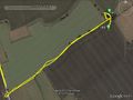
- Arrived. -- Sourcerer (talk) @52.3895,1.4126 16:36, 22 January 2015 (GMT)
The Hash Fairy has been on a roll for the last few weeks, providing easily reached points in eastern England. On Monday I reached six points in one day. Tuesday and Wednesday were good candidates but sadly I was busy with work related matters. Today the hashpoint was 12 km from my home and 15 metres from a public footpath. That is about as easy as it gets.
There was concrete hard standing for loading sugar beet onto lorries. This made an ideal dry car parking place. The public footpath was opposite the car park and it was dry and in perfect condition. The hashpoint was about 600 metres down the path.
With about 15 metres to go, I was on the wrong side of a fence. There was quite a large pool of inky black water. Would the hashpoint require a quick January 3 Celsuis dip?
I backtracked and found a way into the next field. The Hash Fairy came up trumps with the point on the dry banks of the pool. The sight conjured up images from "Lord of the Rings". The air was completely still and the inky black water was reflecting the trees just like a mirror. Sadly no hobbits or dwarves were in evidence.
Having had time, more carefully to review the photo, I'm almost sure there's an Ent photobombing the image.
In fading light, I took a selfie and temporarily blinded myself. Drat!
Finally I set off home leaving Mirrormere behind. On the drive home, I passed a sign towards "Eel's Foot". This led down an alternative footpath to the hashpoint. Perhaps this is the correct name for the pool.
Retro-Hash
Sourcerer re-visited this hashpoint on 2015-02-24 because he had 5 minutes to kill and it was only 80 metres from the 2015-02-25 52 1 point. This allowed an exact midnight arrival at 2015-02-25 52 1. The ent had gone!
Photos
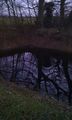
The Hashpool, Eel's Foot / Mirrormere

Drat - Temporarily Blinded
Retro Proof


Achievements
Sourcerer earned the OpenStreetMap achievement
|
Sourcerer earned the Mythical Beast Achievement
|
Expeditions and Plans
| 2015-01-22 | ||
|---|---|---|
| Boston, Massachusetts | Someone went | Near Lexington high school |
| Mannheim, Germany | DODO, Q-Owl | In the middle of a field between Schifferstadt and Waldsee. |
| Norwich, United Kingdom | Sourcerer | Beside a pool between Ilketshall Saint Margaret and Saint James South Elmha... |
Sourcerer's Expedition Links
2015-01-19 52 0 - 2015-01-22 52 1 - 2015-01-25 52 1 - KML file download of Sourcerer's expeditions for use with Google Earth.