Difference between revisions of "2015-05-21 52 1"
imported>Sourcerer m (→Added Achievement) |
imported>FippeBot m (Location) |
||
| (9 intermediate revisions by 2 users not shown) | |||
| Line 3: | Line 3: | ||
| lon=1 | | lon=1 | ||
| date=2015-05-21 | | date=2015-05-21 | ||
| + | | graticule_name=Norwich, UK | ||
| + | | graticule_link=Norwich, United Kingdom | ||
}} | }} | ||
__NOTOC__ | __NOTOC__ | ||
| Line 25: | Line 27: | ||
*Did it! -- [[User:ChromeCrusaders|ChromeCrusaders]] ([[User talk:ChromeCrusaders|talk]]) [http://www.openstreetmap.org/?lat=52.49691467&lon=1.53286984&zoom=16&layers=B000FTF @52.4969,1.5329] 11:12, 21 May 2015 (EDT) | *Did it! -- [[User:ChromeCrusaders|ChromeCrusaders]] ([[User talk:ChromeCrusaders|talk]]) [http://www.openstreetmap.org/?lat=52.49691467&lon=1.53286984&zoom=16&layers=B000FTF @52.4969,1.5329] 11:12, 21 May 2015 (EDT) | ||
| − | |||
| − | |||
| − | |||
| − | |||
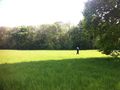
The route followed a public footpath at first. Then we tuned right across a meadow, through an open gate. We followed the field perimeter and were able to go through another gate, not locked. At the far side of this field near the woods, the hashpoint was next to new fencing protecting a recently planted hedge. | The route followed a public footpath at first. Then we tuned right across a meadow, through an open gate. We followed the field perimeter and were able to go through another gate, not locked. At the far side of this field near the woods, the hashpoint was next to new fencing protecting a recently planted hedge. | ||
| Line 37: | Line 35: | ||
<gallery perrow="5"> | <gallery perrow="5"> | ||
| − | + | Image:2015-05-21 52 1 Sourcer 1.jpg | View from the Hashpoint | |
| + | Image:2015-05-21 52 1 Sourcer 2.jpg | Sourcerer | ||
| + | Image:2015-05-21 52 1 Sourcer 3.jpg | ChromeCrusaders | ||
| + | Image:2015-05-21_52_1-selfie.jpeg | Everyone | ||
| + | Image:2015-05-21_52_1-wondering.jpeg| "He looks so free" (Strictly come hash-dancing) | ||
</gallery> | </gallery> | ||
| Line 50: | Line 52: | ||
| name = Sourcerer | | name = Sourcerer | ||
}} | }} | ||
| − | {{ | + | {{Geohashing Day |
| − | |||
| latitude = 52 | | latitude = 52 | ||
| longitude = 1 | | longitude = 1 | ||
| − | | | + | | year = 2015 |
| − | | name = | + | | coorddate= 2015-05-21 |
| + | | name = ChromeCrusaders | ||
| + | | celebration = giving biscuits (awesome) | ||
}} | }} | ||
{{Geohashing Day | {{Geohashing Day | ||
| Line 62: | Line 65: | ||
| year = 2015 | | year = 2015 | ||
| coorddate= 2015-05-21 | | coorddate= 2015-05-21 | ||
| − | | name = | + | | name = Sourcerer |
| − | | celebration = | + | | celebration = getting a gift of biscuits (thanks) |
}} | }} | ||
| − | == | + | {{Sourcerer_links |
| − | + | | prev = 2015-05-20 52 1 | |
| − | + | | curr = 2015-05-21 52 1 | |
| + | | next = 2015-05-23 52 1 | ||
| + | | date = 2015-05-21 | ||
| + | }} | ||
[[Category:Expeditions]] | [[Category:Expeditions]] | ||
[[Category:Expeditions with photos]] | [[Category:Expeditions with photos]] | ||
[[Category:Coordinates reached]] | [[Category:Coordinates reached]] | ||
| + | {{location|GB|ENG|NFK}} | ||
Latest revision as of 03:41, 15 August 2019
| Thu 21 May 2015 in Norwich, UK: 52.4969583, 1.5328411 geohashing.info google osm bing/os kml crox |
Location
A field perimeter, close to Brundish, Norfolk, UK.
Participants
We arrived more or less at the same time having walked together. We were only 10 minutes late for a proper 4 pm meetup. That is a first for the Norwich graticule.
Plans
It's geohashing day - have to attempt this one.
Expedition
- Arrived. -- Sourcerer (talk) @52.4970,1.5329 16:10, 21 May 2015 (GMT+01:00)
- Did it! -- ChromeCrusaders (talk) @52.4969,1.5329 11:12, 21 May 2015 (EDT)
The route followed a public footpath at first. Then we tuned right across a meadow, through an open gate. We followed the field perimeter and were able to go through another gate, not locked. At the far side of this field near the woods, the hashpoint was next to new fencing protecting a recently planted hedge.
Sourcerer says thanks for the biscuits!
Photos
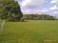
View from the Hashpoint
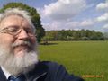
Sourcerer
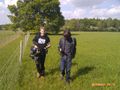
ChromeCrusaders
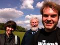
Everyone
"He looks so free" (Strictly come hash-dancing)


Achievements
Sourcerer earned the OpenStreetMap achievement
|
ChromeCrusaders earned the 2015 Geohashing Day achievement
|
Sourcerer earned the 2015 Geohashing Day achievement
|
Expeditions and Plans
| 2015-05-21 | ||
|---|---|---|
| Canberra, Australia | Someone went | Somewhere |
| Big Rapids, Michigan | Mcbaneg, Katja | hillside above a pond north of Cannonsburg, MI, USA |
| Dortmund, Germany | GeorgDerReisende | The hash lay in front of the house nr 5 of the street Am Büter in Dortm... |
| Norwich, United Kingdom | Sourcerer, ChromeCrusaders | A field perimeter, close to Brundish, Norfolk, UK. |
| Hannover, Germany | Fippe | located on a field of rye in Otternhagen. |
| Manchester, United Kingdom | Someone went | located within an open and accessible public backstreet in the town of Leig... |
| Rovaniemi, Finland | isopekka | In Rovaniemi, near a forest road. |
Sourcerer's Expedition Links
2015-05-20 52 1 - 2015-05-21 52 1 - 2015-05-23 52 1 - KML file download of Sourcerer's expeditions for use with Google Earth.