Difference between revisions of "2015-11-26 52 1"
imported>Sourcerer m ([live] Arrived.) |
imported>FippeBot m (Location) |
||
| (8 intermediate revisions by one other user not shown) | |||
| Line 3: | Line 3: | ||
| lon=1 | | lon=1 | ||
| date=2015-11-26 | | date=2015-11-26 | ||
| + | | graticule_name=Norwich, UK | ||
| + | | graticule_link=Norwich, United Kingdom | ||
}} | }} | ||
__NOTOC__ | __NOTOC__ | ||
| Line 8: | Line 10: | ||
== Location == | == Location == | ||
| − | In a hedgerow tucked between the A14 and the railway line to Thetford between Spooner Row and Sutton, Norfolk, UK. | + | 3) In a hedgerow tucked between the A14 and the railway line to Thetford between Spooner Row and Sutton, Norfolk, UK. |
== Participants == | == Participants == | ||
| Line 16: | Line 18: | ||
== Plans == | == Plans == | ||
| − | Expedition three of four spanning midnight - [[2015-11-25 52 1]] - [[2015-11-25 52 0]] - [[2015-11-26 52 1]] - [[2010-03-31 52 1|2010-03-31 52 1 Retro]] - ETA | + | Expedition three of four spanning midnight - [[2015-11-25 52 1]] - [[2015-11-25 52 0]] - [[2015-11-26 52 1]] - [[2010-03-31 52 1|2010-03-31 52 1 Retro]] - ETA 00:00. |
== Expedition == | == Expedition == | ||
| + | *Arrived. -- [[User:Sourcerer|Sourcerer]] ([[User talk:Sourcerer|talk]]) [http://www.openstreetmap.org/?lat=52.54161537&lon=1.09261930&zoom=16&layers=B000FTF @52.5416,1.0926] 00:05, 26 November 2015 (GMT) | ||
| + | There was a good track with a "No Vehicular Access" sign. So perhaps it was fine for pedestrians. This ran parallel with the A11 main road. Later a mown field perimeter path led to a point about 6 metres from the hashpoint. That was good enough to claim success but the walking conditions were ideal so an alternative route was tried. This led to a locked gate with open pedestrian access at the side leading into field of newly planted vines (probably grape) but they were too small to make a safe identification. There were bee hives. They were sleeping due to the cold and dark. This approach got closer at 2 or 3 metres. The actual point was in a dense hedge with a narrow drainage ditch in the middle. Good enough. | ||
| − | |||
| − | |||
== Photos == | == Photos == | ||
<gallery> | <gallery> | ||
| + | Image:2015-11-26_52_1_Sourcerer_1448496237045.jpg | Proof. [http://www.openstreetmap.org/?lat=52.54162073&lon=1.09262466&zoom=16&layers=B000FTF @52.5416,1.0926] | ||
| + | Image:2015-11-26_52_1_Sourcerer_1448497189888.jpg | Better proof. [http://www.openstreetmap.org/?lat=52.54160464&lon=1.09271586&zoom=16&layers=B000FTF @52.5416,1.0927] | ||
| + | Image:2015-11-26_52_1_Sourcerer.jpg | Google Earth Track | ||
</gallery> | </gallery> | ||
| Line 45: | Line 50: | ||
}} | }} | ||
| − | |||
| − | |||
[[Category:Expeditions]] | [[Category:Expeditions]] | ||
[[Category:Expeditions with photos]] | [[Category:Expeditions with photos]] | ||
[[Category:Coordinates reached]] | [[Category:Coordinates reached]] | ||
| − | + | {{location|GB|ENG|NFK}} | |
Latest revision as of 05:58, 15 August 2019
| Thu 26 Nov 2015 in Norwich, UK: 52.5416110, 1.0926939 geohashing.info google osm bing/os kml crox |
Location
3) In a hedgerow tucked between the A14 and the railway line to Thetford between Spooner Row and Sutton, Norfolk, UK.
Participants
Plans
Expedition three of four spanning midnight - 2015-11-25 52 1 - 2015-11-25 52 0 - 2015-11-26 52 1 - 2010-03-31 52 1 Retro - ETA 00:00.
Expedition
- Arrived. -- Sourcerer (talk) @52.5416,1.0926 00:05, 26 November 2015 (GMT)
There was a good track with a "No Vehicular Access" sign. So perhaps it was fine for pedestrians. This ran parallel with the A11 main road. Later a mown field perimeter path led to a point about 6 metres from the hashpoint. That was good enough to claim success but the walking conditions were ideal so an alternative route was tried. This led to a locked gate with open pedestrian access at the side leading into field of newly planted vines (probably grape) but they were too small to make a safe identification. There were bee hives. They were sleeping due to the cold and dark. This approach got closer at 2 or 3 metres. The actual point was in a dense hedge with a narrow drainage ditch in the middle. Good enough.
Photos
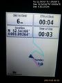
Proof. @52.5416,1.0926
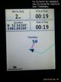
Better proof. @52.5416,1.0927
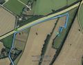
Google Earth Track


Achievements
Sourcerer earned the Midnight Geohash achievement
|
Expeditions and Plans
| 2015-11-26 | ||
|---|---|---|
| Newburgh, New York | Chris 47 8 | Gardnertown Rd, Newburgh, NY |
| Stuttgart, Germany | Klaus, MisterFog, Ekorren, HD, dragalong | next to the street between Lustnau and Pfrondorf in a small (maybe fenced) ... |
| Norwich, United Kingdom | Sourcerer | 3) In a hedgerow tucked between the A14 and the railway line to Thetford be... |
Sourcerer's Expedition Links
2015-11-25 52 0 - 2015-11-26 52 1 - 2015-11-27 52 0 - KML file download of Sourcerer's expeditions for use with Google Earth.