Difference between revisions of "2016-03-28 52 1"
imported>ChromeCrusaders ([live picture]We did it [http://www.openstreetmap.org/?lat=52.79823160&lon=1.47689660&zoom=16&layers=B000FTF @52.7982,1.4769]) |
imported>Fippe ({{location|GB|ENG|NFK}}) |
||
| (5 intermediate revisions by 2 users not shown) | |||
| Line 1: | Line 1: | ||
| − | + | {{meetup graticule | |
| − | |||
| − | |||
| − | |||
| − | |||
| − | |||
| − | |||
| − | |||
| − | |||
| − | |||
| − | {{meetup graticule | ||
| lat=52 | | lat=52 | ||
| lon=1 | | lon=1 | ||
| date=2016-03-28 | | date=2016-03-28 | ||
| + | | graticule_name=Norwich, UK | ||
| + | | graticule_link=Norwich, United Kingdom | ||
}} | }} | ||
| − | |||
| − | |||
__NOTOC__ | __NOTOC__ | ||
| + | == Location == | ||
| − | + | A patch of public land very close to a patch of private land, East Ruston, Norfolk, UK. | |
| − | |||
== Participants == | == Participants == | ||
| − | + | ||
| − | + | *[[User:ChromeCrusaders|ChromeCrusaders]] | |
| + | *[[User:Sourcerer|Sourcerer]] | ||
== Plans == | == Plans == | ||
| − | + | ||
| + | Spur of the moment idea as my friend and I found ourselves bored. | ||
== Expedition == | == Expedition == | ||
| − | |||
| + | === ChromeCrusaders === | ||
*On route | *On route | ||
-- [[User:ChromeCrusaders|ChromeCrusaders]] ([[User talk:ChromeCrusaders|talk]]) 16:43, 28 March 2016 (GMT+01:00) | -- [[User:ChromeCrusaders|ChromeCrusaders]] ([[User talk:ChromeCrusaders|talk]]) 16:43, 28 March 2016 (GMT+01:00) | ||
| − | == | + | |
| − | + | *Arrived. | |
| + | |||
| + | -- [[User:ChromeCrusaders|ChromeCrusaders]] ([[User talk:ChromeCrusaders|talk]]) 18:02, 28 March 2016 (GMT+01:00) | ||
| + | |||
| + | Very easy drive by car, followed by about 20 steps of walking to reach the point. | ||
| + | |||
| + | === Sourcerer === | ||
| + | |||
| + | Expedition one of three spanning midnight - [[2016-03-28 52 1]] - [[2014-09-18 52 1 | 2014-09-18 52 1 Retro]] - [[2016-03-29 52 1]] - ETA 23:25. | ||
| + | |||
| + | The hashpoint was in a hedge about four paces off the road and 15 metres from a grassy parking bay. It's good to see that ChromeCrusaders are still active. | ||
== Photos == | == Photos == | ||
| − | + | ||
| − | |||
| − | |||
<gallery perrow="5"> | <gallery perrow="5"> | ||
| − | + | Image:2016-03-28_52_1_ChromeCrusaders_1459184141594.jpg| ChromeCrusaders did it [http://www.openstreetmap.org/?lat=52.79823160&lon=1.47689660&zoom=16&layers=B000FTF @52.7982,1.4769] | |
| − | Image:2016-03-28_52_1_ChromeCrusaders_1459184141594.jpg| | + | Image:2016-03-28_52_1proof.jpeg | ChromeCrusaders' Proof. |
| + | Image:2016-03-28 52 1 Sourcerer Track.jpg | Sourcerer's Google Earth Track. | ||
| + | Image:2016-03-28 52 1 Sourcerer.jpg | Sourcerer's Proof. | ||
</gallery> | </gallery> | ||
== Achievements == | == Achievements == | ||
{{#vardefine:ribbonwidth|800px}} | {{#vardefine:ribbonwidth|800px}} | ||
| − | |||
| − | + | {{drag-along | |
| − | + | | latitude = 52 | |
| − | + | | longitude = 1 | |
| + | | date = 2016-03-28 | ||
| + | | partner = Joseph | ||
| + | | name = ChromeCrusaders | ||
| + | }} | ||
| − | + | {{Sourcerer_links | |
| − | + | | prev = 2016-03-27 51 0 | |
| − | + | | curr = 2016-03-28 52 1 | |
| − | -- | + | | next = 2016-03-29 52 1 |
| + | | date = 2016-03-28 | ||
| + | }} | ||
| − | |||
| − | |||
| − | |||
[[Category:Expeditions]] | [[Category:Expeditions]] | ||
| − | |||
[[Category:Expeditions with photos]] | [[Category:Expeditions with photos]] | ||
| − | |||
| − | |||
| − | |||
| − | |||
| − | |||
[[Category:Coordinates reached]] | [[Category:Coordinates reached]] | ||
| − | + | {{location|GB|ENG|NFK}} | |
| − | |||
| − | |||
| − | |||
| − | |||
| − | |||
| − | |||
| − | |||
| − | |||
| − | |||
| − | |||
| − | |||
| − | |||
| − | |||
| − | |||
| − | |||
| − | |||
| − | |||
Latest revision as of 20:09, 2 January 2019
| Mon 28 Mar 2016 in Norwich, UK: 52.7981983, 1.4769133 geohashing.info google osm bing/os kml crox |
Location
A patch of public land very close to a patch of private land, East Ruston, Norfolk, UK.
Participants
Plans
Spur of the moment idea as my friend and I found ourselves bored.
Expedition
ChromeCrusaders
- On route
-- ChromeCrusaders (talk) 16:43, 28 March 2016 (GMT+01:00)
- Arrived.
-- ChromeCrusaders (talk) 18:02, 28 March 2016 (GMT+01:00)
Very easy drive by car, followed by about 20 steps of walking to reach the point.
Sourcerer
Expedition one of three spanning midnight - 2016-03-28 52 1 - 2014-09-18 52 1 Retro - 2016-03-29 52 1 - ETA 23:25.
The hashpoint was in a hedge about four paces off the road and 15 metres from a grassy parking bay. It's good to see that ChromeCrusaders are still active.
Photos

ChromeCrusaders did it @52.7982,1.4769
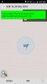
ChromeCrusaders' Proof.
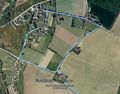
Sourcerer's Google Earth Track.
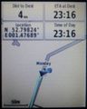
Sourcerer's Proof.


Achievements
ChromeCrusaders earned the Drag-along achievement
|
Expeditions and Plans
| 2016-03-28 | ||
|---|---|---|
| Mannheim, Germany | DODO, Q-Owla, Q-Owl | A field near Stockstadt am Rhein. |
| Norwich, United Kingdom | ChromeCrusaders, Sourcerer | A patch of public land very close to a patch of private land, East Ruston, ... |
Sourcerer's Expedition Links
2016-03-27 51 0 - 2016-03-28 52 1 - 2016-03-29 52 1 - KML file download of Sourcerer's expeditions for use with Google Earth.