Difference between revisions of "2016-07-10 52 1"
From Geohashing
imported>Sourcerer m (→Expedition) |
imported>FippeBot m (Location) |
||
| Line 43: | Line 43: | ||
[[Category:Expeditions with photos]] | [[Category:Expeditions with photos]] | ||
[[Category:Coordinates reached]] | [[Category:Coordinates reached]] | ||
| + | {{location|GB|ENG|SFK}} | ||
Latest revision as of 00:59, 16 August 2019
| Sun 10 Jul 2016 in Norwich, UK: 52.5020188, 1.6925195 geohashing.info google osm bing/os kml crox |
Location
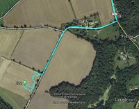
A field west of Flixton Decoy, Norfolk, UK.
Participants
Plans
One of two spanning midnight - 2016-07-10 52 1 - 2016-07-11 52 1 - ETA 23:25.
Expedition
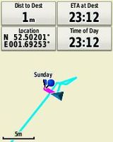
There was a place to park close to the main road. A lane and right of way led in the right direction. The field entrance was not gated and there were clear tractor tracks into the barley crop. The half moon was getting low in the western sky. This was all very pleasant. I had allowed my phone battery to go flat, hence the screen shot instead of the dated live shot.
Photos
Achievements
Expeditions and Plans
| 2016-07-10 | ||
|---|---|---|
| Sacramento, California | Patrick | 38.5020188, -121.6925195 The coordinates in the Sacramento graticule are ... |
| Buffalo, New York | Pedalpusher | In a field next to the Walmart and Dollar Tree parking lots in Springville |
| Portland, Oregon | Jim | In Marquam Park, off a trail |
| Mannheim, Germany | DODO | On a grassland in the forest above Großsachsen |
| Norwich, United Kingdom | Sourcerer | A field west of Flixton Decoy, Norfolk, UK. |
| Amsterdam, Netherlands | FelixTheCat | A field in Heemskerk, Noord-Holland province. |
Sourcerer's Expedition Links
2016-07-09 52 1 - 2016-07-10 52 1 - 2016-07-11 52 1 - KML file download of Sourcerer's expeditions for use with Google Earth.

