Difference between revisions of "2018-09-22 51 9"
imported>GeorgDerReisende (new expedition) |
imported>FippeBot m (Location) |
||
| (18 intermediate revisions by 2 users not shown) | |||
| Line 1: | Line 1: | ||
| − | |||
| − | |||
| − | |||
| − | |||
| − | |||
| − | |||
| − | |||
| − | |||
| − | |||
| − | |||
{{meetup graticule | {{meetup graticule | ||
| lat=51 | | lat=51 | ||
| Line 19: | Line 9: | ||
== Location == | == Location == | ||
| − | + | ||
| + | The hash lies at the eastern end of the Bahnhofstraße in Homberg (Efze). | ||
== Participants == | == Participants == | ||
| − | + | ||
| − | + | * [[User:GeorgDerReisende|GeorgDerReisende]] | |
| + | * [[User:Digiphono|Digiphono]] | ||
== Plans == | == Plans == | ||
| − | + | ||
| + | ===GeorgDerReisende=== | ||
| + | I will use the public transport to Homberg and then I will walk to the hash. I will arrive there around noon. | ||
| + | ===Digiphono=== | ||
| + | I am actually planning to be there exactly at noon, and do a hike through the woods after that... | ||
== Expedition == | == Expedition == | ||
| − | + | ||
| + | ===GeorgDerReisende=== | ||
| + | I travelled by public transport to Homberg and arrived one kilometer above. Then I walked to the hash. As I was 40 meters away I saw a neat little black car curving around and it was Digiphono's. We met, shook hands, and we both looked for the best result. Later we talked for some minutes and then we went away. | ||
| + | |||
| + | ===Digiphono=== | ||
| + | As planned, I left home 11 am and arrived some minutes before noon. Just when I was parking my car, I noticed GeorgDerReisende, coming from the opposite direction. So 'finally' we met, shook hands and talked a little, before we did the last few meters to the hash together. It was located directly at the side of the street 'Bahnhofstraße' where we met up. Nothing spectacular - an 'easy geohash' for sure - a few bushes were all there was to see! So we talked about our hobby another ten minutes or so, and then went separate ways - Georg wanted to do a hike through Homberg, and I wanted to do a walk through the near forests, which I did and enjoyed... It was nice meeting you, Georg! | ||
== Tracklog == | == Tracklog == | ||
| Line 35: | Line 36: | ||
== Photos == | == Photos == | ||
| − | < | + | |
| − | Image: | + | ===GeorgDerReisende=== |
| − | --> | + | <gallery> |
| − | <gallery | + | Image:2018-09-22 51 9 GeorgDerReisende 4331.jpg | Digiphono arriving |
| + | Image:2018-09-22 51 9 GeorgDerReisende 4332.jpg | proof | ||
| + | Image:2018-09-22 51 9 GeorgDerReisende 4334.jpg | Digiphono takes his own proof | ||
| + | Image:2018-09-22 51 9 GeorgDerReisende 4337.jpg | looking east | ||
| + | Image:2018-09-22 51 9 GeorgDerReisende 4338.jpg | looking west | ||
| + | Image:2018-09-22 51 9 GeorgDerReisende 4339.jpg | the hash at south | ||
| + | Image:2018-09-22 51 9 GeorgDerReisende 4340.jpg | looking north | ||
| + | Image:2018-09-22 51 9 GeorgDerReisende 4483.jpg | looking from the tower of the castle to the hash | ||
| + | Image:2018-09-22 51 9 GeorgDerReisende 4527.jpg | a geohash 20 meters behind the tower | ||
| + | </gallery> | ||
| + | |||
| + | ===Digiphono=== | ||
| + | <gallery> | ||
| + | Image:2018-09-22_51_9_001.jpg | The location of the hash | ||
| + | Image:2018-09-22_51_9_002.jpg | The hash | ||
| + | Image:2018-09-22_51_9_003.jpg | The hash - proof | ||
| + | Image:2018-09-22_51_9_004.jpg | The hash - screenshot | ||
| + | Image:2018-09-22_51_9_005.jpg | The nice view on Homberg from the hash | ||
</gallery> | </gallery> | ||
| Line 44: | Line 62: | ||
{{#vardefine:ribbonwidth|800px}} | {{#vardefine:ribbonwidth|800px}} | ||
<!-- Add any achievement ribbons you earned below, or remove this section --> | <!-- Add any achievement ribbons you earned below, or remove this section --> | ||
| + | ===Digiphono=== | ||
| + | {{Two to the N achievement | ||
| + | | count = 3 | ||
| + | | date = 2018-09-22 | ||
| + | | latitude = 51 | ||
| + | | longitude = 9 | ||
| + | | name = Digiphono | ||
| + | | reached = true | ||
| + | }} | ||
| + | |||
| + | {{consecutive geohash 2 | ||
| + | | count = 2 | ||
| + | | latitude = 51 | ||
| + | | longitude = 9 | ||
| + | | date = 2018-09-21 | ||
| + | | name = Digiphono | ||
| + | }} | ||
| − | + | {{Easy_geohash | |
| − | + | | latitude = 51 | |
| − | + | | longitude = 9 | |
| + | | date = 2018-09-22 | ||
| + | | name = Digiphono | ||
| + | }} | ||
| + | {{XKCD Centurion | count = 1 | name = Digiphono }} | ||
| − | + | ===GeorgDerReisende=== | |
| − | + | {{XKCD Centurion | count = 45 | name = GeorgDerReisende }} | |
| − | + | ||
| − | [[ | + | ===both=== |
| − | + | ||
| + | {{meetup|latitude=51|longitude=9|date=2018-09-22|name=[[User:GeorgDerReisende|GeorgDerReisende]] and [[User:Digiphono|Digiphono]]|other=each other}} | ||
| − | |||
| − | |||
[[Category:Expeditions]] | [[Category:Expeditions]] | ||
| − | |||
[[Category:Expeditions with photos]] | [[Category:Expeditions with photos]] | ||
| − | |||
| − | |||
| − | |||
| − | |||
| − | |||
[[Category:Coordinates reached]] | [[Category:Coordinates reached]] | ||
| − | + | {{location|DE|HE|HR}} | |
| − | |||
| − | |||
| − | |||
| − | |||
| − | |||
| − | |||
| − | |||
| − | |||
| − | |||
| − | |||
| − | |||
| − | |||
| − | |||
| − | |||
| − | |||
| − | |||
| − | |||
Latest revision as of 04:07, 16 August 2019
| Sat 22 Sep 2018 in 51,9: 51.0235880, 9.4163743 geohashing.info google osm bing/os kml crox |
Location
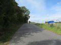
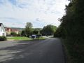
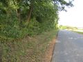
The hash lies at the eastern end of the Bahnhofstraße in Homberg (Efze).
Participants
Plans
GeorgDerReisende
I will use the public transport to Homberg and then I will walk to the hash. I will arrive there around noon.
Digiphono
I am actually planning to be there exactly at noon, and do a hike through the woods after that...
Expedition
GeorgDerReisende
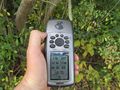
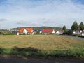
I travelled by public transport to Homberg and arrived one kilometer above. Then I walked to the hash. As I was 40 meters away I saw a neat little black car curving around and it was Digiphono's. We met, shook hands, and we both looked for the best result. Later we talked for some minutes and then we went away.
Digiphono
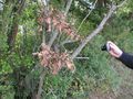
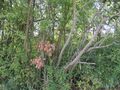
As planned, I left home 11 am and arrived some minutes before noon. Just when I was parking my car, I noticed GeorgDerReisende, coming from the opposite direction. So 'finally' we met, shook hands and talked a little, before we did the last few meters to the hash together. It was located directly at the side of the street 'Bahnhofstraße' where we met up. Nothing spectacular - an 'easy geohash' for sure - a few bushes were all there was to see! So we talked about our hobby another ten minutes or so, and then went separate ways - Georg wanted to do a hike through Homberg, and I wanted to do a walk through the near forests, which I did and enjoyed... It was nice meeting you, Georg!
Tracklog
Photos
GeorgDerReisende
Digiphono arriving
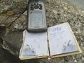
proof
Digiphono takes his own proof
looking east
looking west
the hash at south
looking north
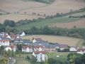
looking from the tower of the castle to the hash
a geohash 20 meters behind the tower


Digiphono
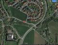
The location of the hash
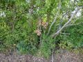
The hash
The hash - proof
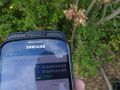
The hash - screenshot
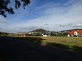
The nice view on Homberg from the hash


Achievements
Digiphono
Digiphono earned the Two to the N achievement
|
Digiphono earned the Consecutive geohash achievement
|
Digiphono has visited an Easy Geohash
|
Digiphono earned the xkcd Nullaturion achievement
|
GeorgDerReisende
GeorgDerReisende earned the xkcd Quadraginturion achievement
|
both
GeorgDerReisende and Digiphono earned the Meet-up achievement
|