Difference between revisions of "2022-04-23 48 14"
(Initial contents, tracklog added) |
m (subst-ing) |
||
| (7 intermediate revisions by 2 users not shown) | |||
| Line 1: | Line 1: | ||
| − | + | [[Image:{{{image| 2022-04-23 48 14 pah 002.jpeg}}}|thumb|right]]{{meetup graticule | |
| − | + | | lat=48 | |
| − | [[Image:{{{image| | + | | lon=14 |
| − | + | | date=2022-04-23 | |
| − | |||
| − | |||
| − | |||
| − | |||
| − | |||
| − | | lat= | ||
| − | | lon= | ||
| − | | date= | ||
}} | }} | ||
__NOTOC__ | __NOTOC__ | ||
| Line 19: | Line 11: | ||
== Participants == | == Participants == | ||
* [[User:Pah|pah]] [[File:U+110DB.png|middle|6px|link=User:Pah]] ([[2022-04-16 19 -155|prev]]| [[2022-04-23 48 15|next]]) | * [[User:Pah|pah]] [[File:U+110DB.png|middle|6px|link=User:Pah]] ([[2022-04-16 19 -155|prev]]| [[2022-04-23 48 15|next]]) | ||
| + | |||
| + | == Plans == | ||
| + | |||
| + | Having both, time and a hashmobile at his disposal today, [[User:Pah|pah]] [[File:U+110DB.png|middle|6px|link=User:Pah]] aims for his first [[Multihash]] by visiting [[2022-04-23 48 14|(48,14)]] first and then proceed to [[2022-04-23 48 15|(48,15)]] afterwards. | ||
== Expedition == | == Expedition == | ||
| − | + | ||
| + | Still being energized by the successful expedition on [[2022-04-16 19 -155|Hawai‘i Island]] last week, pah aimed for his first successful multihash adventure today. Previous attempts were all thwarted, so there is still an open challenge here. Today‘s hashpoints looked very promising, so pah turned his girlfriend‘s car into his hashmobile and gave it a try. | ||
| + | |||
| + | The first hash for [[48,14|(48,14)]] (pah‘s home graticule) was mere 15 km away from home and took around 30 minutes of driving time. Once he arrived in the proximity of the hash (around 600m away), the roads turned from rural to agricultural and he continued the rest of the distance by foot, starting with a walk through a beautiful blossoming avenue. After a few minutes, he reached the field with the hash. At first sight, he was afraid that he would not be able to reach the hash, as the field already had small crops growing on it (maybe corn?). Fortunately, there were tractor tracks heading roughly towards the hash and he dared to enter the field along these tracks without damaging the small crop. | ||
| + | |||
| + | After a few steps, he saw a family of deer on the field around 300 meters away. A group of at least 8 deer of different sizes were resting in the vicinity and even stayed until pah almost reached the hash. Unfortunately, you have to zoom in quite a bit on the picture to see them, pah‘s phone‘s camera really sucks. :-( | ||
| + | |||
| + | After roughly 100 meters, he got even more lucky to realize, that the hash was actually directly '''on the tracks''' and he didn‘t even had to do any hash dance (or any further crop damaging)! Not sure, how recent these tracks were, but the thought that the tractor driver passed right through the hash is funny: This would have been a [[Curse of Unawareness]] combined with a [[Speed racer achievement]](?) — although I‘m not sure what the „maximum (legal) speed“ is on a corn field… | ||
| + | |||
| + | After this easy success, he enjoyed the peacefulness of the place for a few minutes, took some pictures and captured proofs and returned to the hashmobile full of excitement, that the first part of the multihash was done! On his journey towards the [[2022-04-23 48 15|second hash of the day]], Google‘s navigation sent him to a closed train crossing and he had to drive on a gravel road for a bit to find the next open crossing. | ||
| + | |||
| + | Story continues in [[2022-04-23 48 15|(48,15)]] … | ||
== Tracklog == | == Tracklog == | ||
| + | |||
| + | Combined tracklog for [[2022-04-23 48 14|(48,14)]] and [[2022-04-23 48 15|(48,15)]]: | ||
{{tracklog | 2022-04-23 48 14+15 pah tracklog.gpx}} | {{tracklog | 2022-04-23 48 14+15 pah tracklog.gpx}} | ||
| Line 29: | Line 38: | ||
== Photos == | == Photos == | ||
| − | |||
| − | |||
| − | |||
<gallery perrow="5"> | <gallery perrow="5"> | ||
| + | Image:2022-04-23 48 14 pah 001.jpeg | Walking towards the hash | ||
| + | Image:2022-04-23 48 14 pah 002.jpeg | View towards the hash (deer family in the background) | ||
| + | Image:2022-04-23 48 14 pah 004.png | Proof #1 | ||
| + | Image:2022-04-23 48 14 pah 005.png | Proof #2 | ||
| + | Image:2022-04-23 48 14 pah 006.jpeg | [[:Category:Grins|Stupid grin]]™ | ||
| + | Image:2022-04-23 48 14 pah 007.jpeg | Hash with feet | ||
| + | Image:2022-04-23 48 14 pah 008.jpeg | View back from the hash | ||
| + | Image:2022-04-23 48 14 pah 003.jpeg | More view from the hash | ||
| + | Image:2022-04-23 48 14 pah 009.jpeg | Lost in navigation | ||
</gallery> | </gallery> | ||
| Line 47: | Line 62: | ||
| image = 2022-04-23 48 14+15 pah tracklog.jpg | | image = 2022-04-23 48 14+15 pah tracklog.jpg | ||
}} | }} | ||
| − | |||
| − | |||
[[Category:Expeditions]] | [[Category:Expeditions]] | ||
| − | + | [[Category:Expeditions with photos]] | |
[[Category:Coordinates reached]] | [[Category:Coordinates reached]] | ||
| + | {{location|AT|OÖ|EF}} | ||
Latest revision as of 20:46, 24 May 2024

| Sat 23 Apr 2022 in 48,14: 48.2616833, 14.0849674 geohashing.info google osm bing/os kml crox |
Location
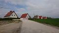
On a field in Polsing in the Alkoven (Upper Austria) municipality.
Participants
Plans
Having both, time and a hashmobile at his disposal today, pah ![]() aims for his first Multihash by visiting (48,14) first and then proceed to (48,15) afterwards.
aims for his first Multihash by visiting (48,14) first and then proceed to (48,15) afterwards.
Expedition
Still being energized by the successful expedition on Hawai‘i Island last week, pah aimed for his first successful multihash adventure today. Previous attempts were all thwarted, so there is still an open challenge here. Today‘s hashpoints looked very promising, so pah turned his girlfriend‘s car into his hashmobile and gave it a try.
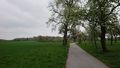
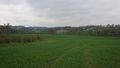
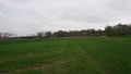
The first hash for (48,14) (pah‘s home graticule) was mere 15 km away from home and took around 30 minutes of driving time. Once he arrived in the proximity of the hash (around 600m away), the roads turned from rural to agricultural and he continued the rest of the distance by foot, starting with a walk through a beautiful blossoming avenue. After a few minutes, he reached the field with the hash. At first sight, he was afraid that he would not be able to reach the hash, as the field already had small crops growing on it (maybe corn?). Fortunately, there were tractor tracks heading roughly towards the hash and he dared to enter the field along these tracks without damaging the small crop.
After a few steps, he saw a family of deer on the field around 300 meters away. A group of at least 8 deer of different sizes were resting in the vicinity and even stayed until pah almost reached the hash. Unfortunately, you have to zoom in quite a bit on the picture to see them, pah‘s phone‘s camera really sucks. :-(
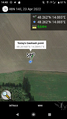
After roughly 100 meters, he got even more lucky to realize, that the hash was actually directly on the tracks and he didn‘t even had to do any hash dance (or any further crop damaging)! Not sure, how recent these tracks were, but the thought that the tractor driver passed right through the hash is funny: This would have been a Curse of Unawareness combined with a Speed racer achievement(?) — although I‘m not sure what the „maximum (legal) speed“ is on a corn field…
After this easy success, he enjoyed the peacefulness of the place for a few minutes, took some pictures and captured proofs and returned to the hashmobile full of excitement, that the first part of the multihash was done! On his journey towards the second hash of the day, Google‘s navigation sent him to a closed train crossing and he had to drive on a gravel road for a bit to find the next open crossing.
Story continues in (48,15) …
Tracklog
Combined tracklog for (48,14) and (48,15):

Photos
Walking towards the hash
View towards the hash (deer family in the background)

Proof #1
Proof #2
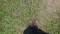
Hash with feet
View back from the hash
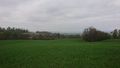
More view from the hash
Lost in navigation


Achievements
pah
|