Difference between revisions of "2022-08-17 45 -122"
From Geohashing
Michael5000 (talk | contribs) (→Location) |
m (subst-ing) |
||
| (3 intermediate revisions by 2 users not shown) | |||
| Line 8: | Line 8: | ||
And DON'T FORGET to add your expedition and the best photo you took to the gallery on the Main Page! We'd love to read your report, but that means we first have to discover it! :) | And DON'T FORGET to add your expedition and the best photo you took to the gallery on the Main Page! We'd love to read your report, but that means we first have to discover it! :) | ||
-->{{meetup graticule | -->{{meetup graticule | ||
| − | | lat= | + | | lat=45 |
| − | | lon= | + | | lon=-122 |
| − | | date= | + | | date=2022-08-17 |
}}<!-- edit as necessary --> | }}<!-- edit as necessary --> | ||
== Location == | == Location == | ||
| Line 17: | Line 17: | ||
== Participants == | == Participants == | ||
| − | |||
| − | |||
| − | + | *[[user:Michael5000|Michael5000]] | |
| − | |||
== Expedition == | == Expedition == | ||
| − | |||
| − | + | In the evening, I drove down to Cook Park in Tigard, or in Durham -- I'm not real clear on where the edges of Durham are, I don't think anyone is -- with the idea that I would run along park trails most of the way to the hashpoint. At some point I took a wrong turn and ended up on suburban roads, and it was very hot and humid so eventually I had to stop and walk. And then I got to the hashpoint, which was, like, on a street. | |
| − | + | ||
| + | I did a better job of finding the park trails on the return journey, and ran most of the way to my car. | ||
== Photos == | == Photos == | ||
| − | |||
| − | |||
| − | |||
<gallery perrow="5"> | <gallery perrow="5"> | ||
| + | File:2022-08-17 45 -122 a.jpg|It was a warm day for exercise. | ||
| + | File:2022-08-17 45 -122 b.jpg|There was a church nearby. | ||
</gallery> | </gallery> | ||
| Line 41: | Line 37: | ||
__NOTOC__ | __NOTOC__ | ||
| − | |||
| − | |||
| − | |||
| − | |||
| − | |||
| − | |||
| − | |||
| − | |||
| − | |||
| − | |||
| − | |||
| − | |||
| − | |||
[[Category:Expeditions]] | [[Category:Expeditions]] | ||
| − | |||
[[Category:Expeditions with photos]] | [[Category:Expeditions with photos]] | ||
| − | |||
| − | |||
| − | |||
| − | |||
| − | |||
[[Category:Coordinates reached]] | [[Category:Coordinates reached]] | ||
| − | + | {{location|US|OR|WI}} | |
| − | |||
| − | |||
| − | |||
| − | |||
| − | |||
| − | |||
| − | |||
| − | |||
| − | |||
| − | |||
| − | |||
| − | |||
| − | |||
| − | |||
| − | |||
| − | |||
| − | |||
Latest revision as of 20:51, 24 May 2024
| Wed 17 Aug 2022 in 45,-122: 45.3896796, -122.7529534 geohashing.info google osm bing/os kml crox |
Location
Off of Lower Boones Ferry Road.
Participants
Expedition
In the evening, I drove down to Cook Park in Tigard, or in Durham -- I'm not real clear on where the edges of Durham are, I don't think anyone is -- with the idea that I would run along park trails most of the way to the hashpoint. At some point I took a wrong turn and ended up on suburban roads, and it was very hot and humid so eventually I had to stop and walk. And then I got to the hashpoint, which was, like, on a street.
I did a better job of finding the park trails on the return journey, and ran most of the way to my car.
Photos
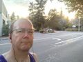
It was a warm day for exercise.
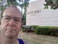
There was a church nearby.

