Difference between revisions of "2022-10-23 45 -122"
From Geohashing
Michael5000 (talk | contribs) |
m (subst-ing) |
||
| (One intermediate revision by the same user not shown) | |||
| Line 8: | Line 8: | ||
And DON'T FORGET to add your expedition and the best photo you took to the gallery on the Main Page! We'd love to read your report, but that means we first have to discover it! :) | And DON'T FORGET to add your expedition and the best photo you took to the gallery on the Main Page! We'd love to read your report, but that means we first have to discover it! :) | ||
-->{{meetup graticule | -->{{meetup graticule | ||
| − | | lat= | + | | lat=45 |
| − | | lon= | + | | lon=-122 |
| − | | date= | + | | date=2022-10-23 |
}}<!-- edit as necessary --> | }}<!-- edit as necessary --> | ||
== Location == | == Location == | ||
| Line 42: | Line 42: | ||
[[Category:Expeditions with photos]] | [[Category:Expeditions with photos]] | ||
[[Category:Coordinates reached]] | [[Category:Coordinates reached]] | ||
| + | {{location|US|WA|CR}} | ||
Latest revision as of 20:52, 24 May 2024
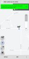
| Sun 23 Oct 2022 in 45,-122: 45.7590737, -122.4610147 geohashing.info google osm bing/os kml crox |
Location
In the Hockinson neighborhood, northeast of Vancouver.
Participants
Expedition
After finding a place to park by a church in the little Hockinson village center, my plan was to run to the hashpoint -- just off NE 189th Avenue, a few miles to the northeast -- and then run back. The area turned out to be quite a bit more hilly than I expected, and I wasn't able to make it happen. I ran about 3.6 of the miles, but ended up walking another one and a half. It's all good.
Photos
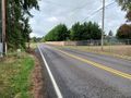
Looking west from the hashpoint.
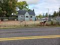
Looking north from the hashpoint.
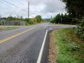
Looking east from the hashpoint.
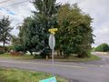
The nearest intersection. The hashpoint is on the left margin of the road on the right side of the picture.
Voila.


