Difference between revisions of "2023-07-18 45 -122"
From Geohashing
Michael5000 (talk | contribs) (→Achievements) |
m (subst-ing) |
||
| (2 intermediate revisions by 2 users not shown) | |||
| Line 8: | Line 8: | ||
And DON'T FORGET to add your expedition and the best photo you took to the gallery on the Main Page! We'd love to read your report, but that means we first have to discover it! :) | And DON'T FORGET to add your expedition and the best photo you took to the gallery on the Main Page! We'd love to read your report, but that means we first have to discover it! :) | ||
-->{{meetup graticule | -->{{meetup graticule | ||
| − | | lat= | + | | lat=45 |
| − | | lon= | + | | lon=-122 |
| − | | date= | + | | date=2023-07-18 |
}}<!-- edit as necessary --> | }}<!-- edit as necessary --> | ||
== Location == | == Location == | ||
| Line 19: | Line 19: | ||
*[[user:Michael5000|Michael5000]] | *[[user:Michael5000|Michael5000]] | ||
| − | |||
| − | |||
| − | |||
== Expedition == | == Expedition == | ||
The workday ended and I was a little at loose ends myself, so I took a look at the hashpoint again and this time I noticed that there was a trail nearby that I'd never run on before. So, I drove down and parked down a gravel road nearby, walked out to the hashpoint, took a few pictures, and then went for a little run down the trail and some of the side roads. | The workday ended and I was a little at loose ends myself, so I took a look at the hashpoint again and this time I noticed that there was a trail nearby that I'd never run on before. So, I drove down and parked down a gravel road nearby, walked out to the hashpoint, took a few pictures, and then went for a little run down the trail and some of the side roads. | ||
| − | |||
| − | |||
| − | |||
== Photos == | == Photos == | ||
| Line 52: | Line 46: | ||
[[Category:Coordinates reached]] | [[Category:Coordinates reached]] | ||
| + | {{location|US|OR|CC}} | ||
Latest revision as of 21:02, 24 May 2024
| Tue 18 Jul 2023 in 45,-122: 45.3717819, -122.3759162 geohashing.info google osm bing/os kml crox |
Location
On the side of Oregon 224 a few miles north of Estacada.
Participants
Expedition
The workday ended and I was a little at loose ends myself, so I took a look at the hashpoint again and this time I noticed that there was a trail nearby that I'd never run on before. So, I drove down and parked down a gravel road nearby, walked out to the hashpoint, took a few pictures, and then went for a little run down the trail and some of the side roads.
Photos
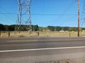
Looking up the powerlines from the hashpoint
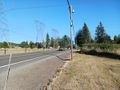
Looking up the highway from the hashpoint
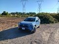
Vehicle stashed nearby
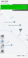
Hashpoint


