Difference between revisions of "2023-08-19 45 -123"
Michael5000 (talk | contribs) (→Participants) |
m (subst-ing) |
||
| (3 intermediate revisions by 2 users not shown) | |||
| Line 1: | Line 1: | ||
| − | + | {{meetup graticule | |
| − | + | | lat=45 | |
| − | + | | lon=-123 | |
| − | + | | date=2023-08-19 | |
| − | |||
| − | |||
| − | |||
| − | |||
| − | |||
| − | | lat= | ||
| − | | lon= | ||
| − | | date= | ||
}}<!-- edit as necessary --> | }}<!-- edit as necessary --> | ||
== Location == | == Location == | ||
| − | + | In the woods north of Klootchy Creek County Park. | |
== Participants == | == Participants == | ||
*[[user:Michael5000|Michael5000]] | *[[user:Michael5000|Michael5000]] | ||
| − | == | + | == Expedition == |
| − | + | Disappointed but undaunted after [[2023-08-19 45 -122]], I struck west from St Helens towards Vernonia, and promptly got caught in a poorly signed system of detours that kept me driving in pointless loops for a while without ever really making clear that the road to Vernonia wasn't available. | |
| − | + | Only mildly daunted, I dipped south to Scappoose, took the road from there to Vernonia, went south all the way to Manning like a noob instead of taking the Timber cutoff, and finally headed northwest (through Timber, eventually) on US 26 towards Klootchy Creek County Park, a few miles inland from the Coast. Some years ago, I got the car briefly stuck by backing off of the shoulder of a bridge ramp at this park on the way to [[2011-07-24 45 -123]]. I was more careful this time. | |
| − | + | ||
| + | The area is apparently popular with mountain biker types, and as I was unloading the bike a guy who was packing up his own bike announced "Hey, I don't want to be dramatic, but I just encountered a bear back there!" That was thought-provoking of course, but as his sighting had been a few miles away, the only real information it contained is that bears live in the forest, and I already knew that, so I continued. | ||
| − | + | The ride took me down a series of three clear but increasingly low-fi forest roads, on which I overshot the hashpoint by quite a ways and then circled back to it from the north, both to get as close as I could on roads and to avoid too steep a climb. At the end, it looked like I might be able to walk right up to it in a grassy meadow -- but nope, the final twenty feet or so were down a forested cliff. I scrambled down, scrambled back up, made it back to the park without any unfortunate ursine encounters, and set my sights on [[2023-08-19 44 -123]]. | |
| − | |||
== Photos == | == Photos == | ||
| − | |||
| − | |||
| − | |||
<gallery perrow="5"> | <gallery perrow="5"> | ||
| + | File:2023-08-19 45 -123 a.jpg|This park used to feature a very large tree, but it perished in a storm some years ago | ||
| + | File:2023-08-19 45 -123 b.jpg|The second forest road branches off... | ||
| + | File:2023-08-19 45 -123 c.jpg|The third forest road | ||
| + | File:2023-08-19 45 -123 d.jpg|The hashpoint is just past the end of this meadow... and down a cliff | ||
| + | File:2023-08-19 45 -123 e.jpg|View north from the hashpoint | ||
| + | File:2023-08-19 45 -123 f.jpg|Me at the hashpoint, oblivious of forest debris | ||
| + | File:2023-08-19 45 -123 g.jpg|Voila | ||
</gallery> | </gallery> | ||
| Line 39: | Line 35: | ||
__NOTOC__ | __NOTOC__ | ||
| − | |||
| − | |||
| − | |||
| − | |||
| − | |||
| − | |||
| − | |||
| − | |||
| − | |||
| − | |||
| − | |||
| − | |||
| − | |||
[[Category:Expeditions]] | [[Category:Expeditions]] | ||
| − | |||
[[Category:Expeditions with photos]] | [[Category:Expeditions with photos]] | ||
| − | |||
| − | |||
| − | |||
| − | |||
| − | |||
[[Category:Coordinates reached]] | [[Category:Coordinates reached]] | ||
| − | + | {{location|US|OR|CT}} | |
| − | |||
| − | |||
| − | |||
| − | |||
| − | |||
| − | |||
| − | |||
| − | |||
| − | |||
| − | |||
| − | |||
| − | |||
| − | |||
| − | |||
| − | |||
| − | |||
| − | |||
Latest revision as of 21:04, 24 May 2024
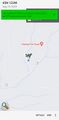
| Sat 19 Aug 2023 in 45,-123: 45.9243995, -123.8580770 geohashing.info google osm bing/os kml crox |
Location
In the woods north of Klootchy Creek County Park.
Participants
Expedition
Disappointed but undaunted after 2023-08-19 45 -122, I struck west from St Helens towards Vernonia, and promptly got caught in a poorly signed system of detours that kept me driving in pointless loops for a while without ever really making clear that the road to Vernonia wasn't available.
Only mildly daunted, I dipped south to Scappoose, took the road from there to Vernonia, went south all the way to Manning like a noob instead of taking the Timber cutoff, and finally headed northwest (through Timber, eventually) on US 26 towards Klootchy Creek County Park, a few miles inland from the Coast. Some years ago, I got the car briefly stuck by backing off of the shoulder of a bridge ramp at this park on the way to 2011-07-24 45 -123. I was more careful this time.
The area is apparently popular with mountain biker types, and as I was unloading the bike a guy who was packing up his own bike announced "Hey, I don't want to be dramatic, but I just encountered a bear back there!" That was thought-provoking of course, but as his sighting had been a few miles away, the only real information it contained is that bears live in the forest, and I already knew that, so I continued.
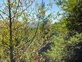
The ride took me down a series of three clear but increasingly low-fi forest roads, on which I overshot the hashpoint by quite a ways and then circled back to it from the north, both to get as close as I could on roads and to avoid too steep a climb. At the end, it looked like I might be able to walk right up to it in a grassy meadow -- but nope, the final twenty feet or so were down a forested cliff. I scrambled down, scrambled back up, made it back to the park without any unfortunate ursine encounters, and set my sights on 2023-08-19 44 -123.
Photos
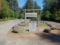
This park used to feature a very large tree, but it perished in a storm some years ago
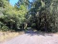
The second forest road branches off...
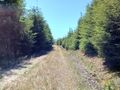
The third forest road
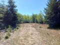
The hashpoint is just past the end of this meadow... and down a cliff
View north from the hashpoint

Me at the hashpoint, oblivious of forest debris
Voila


