Difference between revisions of "2024-04-14 45 -122"
From Geohashing
Michael5000 (talk | contribs) (Created page with "{{subst:Expedition}}") |
m (subst-ing) |
||
| (6 intermediate revisions by 2 users not shown) | |||
| Line 8: | Line 8: | ||
And DON'T FORGET to add your expedition and the best photo you took to the gallery on the Main Page! We'd love to read your report, but that means we first have to discover it! :) | And DON'T FORGET to add your expedition and the best photo you took to the gallery on the Main Page! We'd love to read your report, but that means we first have to discover it! :) | ||
-->{{meetup graticule | -->{{meetup graticule | ||
| − | | lat= | + | | lat=45 |
| − | | lon= | + | | lon=-122 |
| − | | date= | + | | date=2024-04-14 |
}}<!-- edit as necessary --> | }}<!-- edit as necessary --> | ||
== Location == | == Location == | ||
| − | + | In an apartment complex on Kinnaman Road. | |
== Participants == | == Participants == | ||
| − | + | *[[user:Michael5000|Michael5000]] | |
| − | |||
| − | |||
| − | |||
| − | |||
== Expedition == | == Expedition == | ||
| − | |||
| − | + | I took some friends to the airport at 6:30, then drove over to Beaverton, had a light breakfast, and did a little grocery shopping. Then, I parked at the Tualatin Hills Nature Park and ran about two miles to the hashpoint, which was -- perhaps not surprisingly -- fairly unremarkable. Then I finished my run, my errands, and eventually my day and week. | |
| − | |||
== Photos == | == Photos == | ||
| − | |||
| − | |||
| − | |||
<gallery perrow="5"> | <gallery perrow="5"> | ||
| + | File:2024-04-14 45 -122 a.jpg|The apartment complex | ||
| + | File:2024-04-14 45 -122 b.jpg|View from the hashpoint | ||
| + | File:2024-04-14 45 -122 c.jpg|Inspiring message visible from the hashpoint | ||
| + | File:2024-04-14 45 -122 d.jpg| | ||
</gallery> | </gallery> | ||
| Line 40: | Line 35: | ||
__NOTOC__ | __NOTOC__ | ||
| − | |||
| − | |||
| − | |||
| − | |||
| − | |||
| − | |||
| − | |||
| − | |||
| − | |||
| − | |||
| − | |||
| − | |||
| − | |||
[[Category:Expeditions]] | [[Category:Expeditions]] | ||
| − | |||
[[Category:Expeditions with photos]] | [[Category:Expeditions with photos]] | ||
| − | |||
| − | |||
| − | |||
| − | |||
| − | |||
[[Category:Coordinates reached]] | [[Category:Coordinates reached]] | ||
| − | + | {{location|US|OR|WI}} | |
| − | |||
| − | |||
| − | |||
| − | |||
| − | |||
| − | |||
| − | |||
| − | |||
| − | |||
| − | |||
| − | |||
| − | |||
| − | |||
| − | |||
| − | |||
| − | |||
| − | |||
Latest revision as of 21:19, 24 May 2024
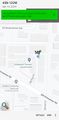
| Sun 14 Apr 2024 in 45,-122: 45.4838776, -122.8611153 geohashing.info google osm bing/os kml crox |
Location
In an apartment complex on Kinnaman Road.
Participants
Expedition
I took some friends to the airport at 6:30, then drove over to Beaverton, had a light breakfast, and did a little grocery shopping. Then, I parked at the Tualatin Hills Nature Park and ran about two miles to the hashpoint, which was -- perhaps not surprisingly -- fairly unremarkable. Then I finished my run, my errands, and eventually my day and week.
Photos
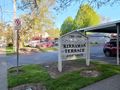
The apartment complex
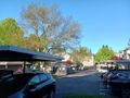
View from the hashpoint

Inspiring message visible from the hashpoint