Difference between revisions of "2012-09-28 52 1"
imported>Sourcerer m ([live] Arrived.) |
imported>Sourcerer m (→New Expedition) |
||
| Line 1: | Line 1: | ||
| − | |||
| − | |||
| − | |||
| − | |||
| − | |||
| − | |||
| − | |||
| − | |||
| − | |||
| − | |||
{{meetup graticule | {{meetup graticule | ||
| − | | lat=52 | + | | lat=52 |
| − | | lon=1 | + | | lon=1 |
| − | | date=2012-09-28 | + | | date=2012-09-28 |
| + | | graticule_name=Norwich | ||
| + | | graticule_link=Norwich, United Kingdom | ||
}} | }} | ||
| − | |||
| − | |||
== Location == | == Location == | ||
| − | + | ||
| + | In a harvested wheat field next to the A149 road from Cromer to Great Yarmouth, Norfolk, UK. | ||
== Participants == | == Participants == | ||
| − | |||
| − | |||
| − | + | [[User:Sourcerer|Sourcerer]] | |
| − | |||
== Expedition == | == Expedition == | ||
| − | |||
| + | *Arrived. -- [[User:Sourcerer|Sourcerer]] [http://www.openstreetmap.org/?lat=52.79783070087433&lon=1.4111852645874023&zoom=16&layers=B000FTF @52.7978,1.4112] 17:16, 28 September 2012 (GMT+01:00) | ||
| − | + | On the commute home via the dog food shop, Neil took in this hashpoint. There was convenient parking in a lay-by 250 metres away. Easy access to the harvested field was up a small dry bank. There was a track of sorts. Perhaps this was made by wild animals or perhaps a ninja hasher passed this way. The hashpoint was a few paces from the field edge. The weather was breezy with sun, showers and rainbows. The GPS position was wandering about making the zero point impossible to find. You could get the distance down to a metre but standing still, it would creep up again. The convection clouds were probably acting like lenses or prisms. | |
| − | |||
| − | |||
== Photos == | == Photos == | ||
| − | < | + | |
| − | Image:2012- | + | <gallery> |
| − | -- | + | Image:2012-09-28 52 1 Sourcerer 1.jpg|The Hashpoint |
| − | + | Image:2012-09-28 52 1 Sourcerer 2.jpg|The Hashpoint | |
| + | Image:2012-09-28 52 1 Sourcerer 3.jpg|The Evidence | ||
</gallery> | </gallery> | ||
| − | == | + | == Other geohashing expeditions on the same day == |
| − | |||
| − | |||
| − | |||
| − | |||
| − | |||
| − | |||
| − | |||
| − | + | {{expedition summaries|2012-09-28}} | |
| − | |||
| − | |||
| − | |||
| − | |||
[[Category:Expeditions]] | [[Category:Expeditions]] | ||
| − | |||
[[Category:Expeditions with photos]] | [[Category:Expeditions with photos]] | ||
| − | |||
| − | |||
| − | |||
| − | |||
| − | |||
[[Category:Coordinates reached]] | [[Category:Coordinates reached]] | ||
| − | |||
| − | |||
| − | |||
| − | |||
| − | |||
| − | |||
| − | |||
| − | |||
| − | |||
| − | |||
| − | |||
| − | |||
| − | |||
| − | |||
| − | |||
| − | |||
| − | |||
| − | |||
Revision as of 19:29, 28 September 2012
| Fri 28 Sep 2012 in Norwich: 52.7978383, 1.4112076 geohashing.info google osm bing/os kml crox |
Contents
Location
In a harvested wheat field next to the A149 road from Cromer to Great Yarmouth, Norfolk, UK.
Participants
Expedition
- Arrived. -- Sourcerer @52.7978,1.4112 17:16, 28 September 2012 (GMT+01:00)
On the commute home via the dog food shop, Neil took in this hashpoint. There was convenient parking in a lay-by 250 metres away. Easy access to the harvested field was up a small dry bank. There was a track of sorts. Perhaps this was made by wild animals or perhaps a ninja hasher passed this way. The hashpoint was a few paces from the field edge. The weather was breezy with sun, showers and rainbows. The GPS position was wandering about making the zero point impossible to find. You could get the distance down to a metre but standing still, it would creep up again. The convection clouds were probably acting like lenses or prisms.
Photos
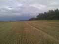
The Hashpoint
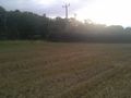
The Hashpoint
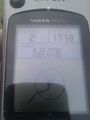
The Evidence


Other geohashing expeditions on the same day
Expeditions and Plans
| 2012-09-28 | ||
|---|---|---|
| Auckland, New Zealand | Greenslime, JimmyNZ | Beachside, Muriwai Beach, Auckland |
| Santa Ana, California | Stephen Cerruti, LucasBrown, A' | In a field near Carlsbad State Beach. |
| Cumberland, Maryland | LDakota66 | Off Laurel Grove Rd in rural Frederick County, VA. |
| Norwich, United Kingdom | Sourcerer | In a harvested wheat field next to the A149 road from Cromer to Great Yarmo... |
| Moscow, Russia | vb | A lawn in Strogino district of Moscow. |