Difference between revisions of "User:RecentlyChanged"
From Geohashing
imported>RecentlyChanged (→2012) |
imported>RecentlyChanged |
||
| Line 20: | Line 20: | ||
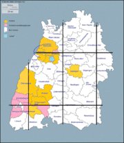
| − | [[Image:Bezirke.gif| | + | [[Image:Bezirke.gif|180px|right]]I'm working on the [[Regional_geohashing_achievement|regional geohashing]] and the [[Reverse_regional_achievement|reverse regional]] achievements on the level of districts in all my two graticules (so far ;) ). My progress is in the picture. <!-- idea from Eupeodes, thank you --> |
| Line 49: | Line 49: | ||
#[[2012-09-06 48 8]]: Made my first hash, dragging along a girl, picnic and slackline | #[[2012-09-06 48 8]]: Made my first hash, dragging along a girl, picnic and slackline | ||
| + | ===Thinking about:=== | ||
| + | #the [[2012-11-15 48 8]] Hash: How big is the probability to came this near to the Hashpoint? | ||
| + | What I need to answer this: | ||
| + | How big is the border of the district? How big is a Geohash (in 48 8)? How do I calculate it? | ||
==Achievements== | ==Achievements== | ||
Revision as of 15:51, 17 December 2012
Contents
Introduction
Geohasher from Germany, now living on top of the graticule Pforzheim, about 25 minutes from Karlsruhe.
Plans
- Visit my Birtdayhash 1994-02-03 48 8
- Drag along as much people as so far
- Meet up with other Geohashers
- Cross the border to:
- France
- Swiss
- Austria
- and others
- make a Water Geohash
- make a puppetmaster Achievement
Statistics
I'm working on the regional geohashing and the reverse regional achievements on the level of districts in all my two graticules (so far ;) ). My progress is in the picture.
traveled with:
- feet:22km
- bike:170km
- tram:92km
- car:60km
full distance for Geohashing: 344km
Expeditions
Most recent first.
2012
- 2012-12-13 48 8: After being in the hospital making a damn cold midnight geohash
- 2012-12-11 49 8: Lot of tram
- 2012-11-24 48 8: In a forest, Tron, travelled with bike
- 2012-11-23 49 8: (Jewish) Graveyard at midnight ...
- 2012-11-22 49 8: On a field, wow xD
- 2012-11-15 48 8: Took the tram, walked an hour. Not in the district Pforzheim, distance less than 100m.
- 2012-11-06 48 8: Biketour, back in the dark
- 2012-11-05 49 8: Made my first Hash in 49,8 and introduced Deuded into geohashing
- 2012-10-30 48 8: Trying to visit the Hashpoint but deleted the coordinates -> failed
- 2012-09-09 48 8: Bikemarathon (while [1]) dragging along my father
- 2012-09-07 48 8: Made my first big bike tour, made a tron, crazy tour
- 2012-09-06 48 8: Made my first hash, dragging along a girl, picnic and slackline
Thinking about:
- the 2012-11-15 48 8 Hash: How big is the probability to came this near to the Hashpoint?
What I need to answer this: How big is the border of the district? How big is a Geohash (in 48 8)? How do I calculate it?
Achievements
"Normal"-Achievements
arranged in negative order of rate:
 █ (1)
█ (1) █ (1)
█ (1) █ (1)
█ (1)- 40px █ (1)
 █ (1)
█ (1) █ (1)
█ (1) █ (1)
█ (1) █ (1)
█ (1) █ (1)
█ (1) █ (1) (3 in a row)
 ██ (2)
 ██ (2)
 ██ (2) (2 in a row)
 ████ (4)
 ████ (4)
 █████ (5)
 █████████ (9)

