Difference between revisions of "2015-10-16 52 1"
From Geohashing
imported>Sourcerer m (→Photos) |
imported>Sourcerer m (→Achievements) |
||
| Line 32: | Line 32: | ||
== Achievements == | == Achievements == | ||
{{#vardefine:ribbonwidth|700px}} | {{#vardefine:ribbonwidth|700px}} | ||
| + | |||
| + | {{OpenStreetMap achievement | ||
| + | | latitude = 52 | ||
| + | | longitude = 1 | ||
| + | | date = 2015-10-16 | ||
| + | | OSMlink = 34667107 | ||
| + | | name = Sourcerer | ||
| + | }} | ||
{{Sourcerer_links | {{Sourcerer_links | ||
Revision as of 02:39, 16 October 2015
| Fri 16 Oct 2015 in 52,1: 52.2485925, 1.0818851 geohashing.info google osm bing/os kml crox |
Location
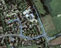
In the middle of Freelands (road), Mendlesham, Suffolk, UK - no need to get out of the car!
Participants
Plans
Expedition six of six spanning midnight.
2015-10-15 52 1 - 2015-10-15 52 0 - 2015-10-15 52 -0 - 2015-10-16 52 -0 - 2015-10-16 52 0 - 2015-10-16 52 1 - ETA 01:40.
Expedition
- Arrived. -- Sourcerer (talk) @52.2481,1.0826 01:50, 16 October 2015 (GMT+01:00)
Photos
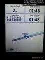
Proof. @52.2481,1.0826
Track in Google Earth


Achievements
Sourcerer earned the OpenStreetMap achievement
|
Expeditions and Plans
| 2015-10-16 | ||
|---|---|---|
| Northampton, United Kingdom | Sourcerer | 4) In a field south west of Elsworth, Cambridgeshire, UK. |
| Cambridge, United Kingdom | Sourcerer, Benjw, Tongs/B | 5) A road hashpoint between Oakington and Girton, Cambridgeshire, UK. |
| Norwich, United Kingdom | Sourcerer | 6) In the middle of Freelands (road), Mendlesham, Suffolk, UK - no need to ... |
Sourcerer's Expedition Links
2015-10-16 52 0 - 2015-10-16 52 1 - 2015-10-17 52 1 - KML file download of Sourcerer's expeditions for use with Google Earth.