Difference between revisions of "2017-07-16 52 0"
From Geohashing
imported>Sourcerer m (→New expedition) |
imported>Sourcerer m (→Fixed a link) |
||
| Line 1: | Line 1: | ||
{{meetup graticule | {{meetup graticule | ||
| lat=52 | | lat=52 | ||
| − | | lon= | + | | lon=0 |
| date=2017-07-16 | | date=2017-07-16 | ||
| graticule_name=Cambridge, UK | | graticule_name=Cambridge, UK | ||
Revision as of 21:29, 16 July 2017
| Sun 16 Jul 2017 in Cambridge, UK: 52.8192469, 0.8218976 geohashing.info google osm bing/os kml crox |
Location
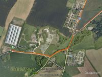
The access road leading to a biogas plant, SW of Fakenham, Norfolk, UK.
Participants
Plans
Go after walking with the Waveney Ramblers. This adds only 3 km to my journey.
Expedition
This was a road point on the access track leading to a biogas plant. There was no traffic on this road so I could take the time to get an evidence photo.
Photos
- Gallery
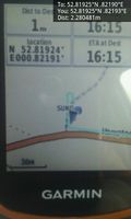
Arrived. @52.8193,.8219
Achievements
Expeditions and Plans
| 2017-07-16 | ||
|---|---|---|
| Beersheba, Israel | Yosef | A field between Yad Binyamin and Mazkeret Batya The point looked like it w... |
| Buffalo, New York | Pedalpusher | Veteran's Park in Lackawana, in the middle of the playing field |
| La Pine, Oregon | Beejjorgensen | SW of Bend, OR, USA. |
| Cambridge, United Kingdom | Sourcerer | The access road leading to a biogas plant, SW of Fakenham, Norfolk, UK. |
| Joensuu, Finland | Tilley | In the forest in a place called Kukkoliete (what a strange name, "Rooster S... |
Sourcerer's Expedition Links
2017-07-13 52 1 - 2017-07-16 52 0 - 2017-07-18 52 1 - KML file download of Sourcerer's expeditions for use with Google Earth.

