Difference between revisions of "2021-11-28 45 -122"
From Geohashing
Michael5000 (talk | contribs) (→Participants) |
m (subst-ing) |
||
| Line 8: | Line 8: | ||
And DON'T FORGET to add your expedition and the best photo you took to the gallery on the Main Page! We'd love to read your report, but that means we first have to discover it! :) | And DON'T FORGET to add your expedition and the best photo you took to the gallery on the Main Page! We'd love to read your report, but that means we first have to discover it! :) | ||
-->{{meetup graticule | -->{{meetup graticule | ||
| − | | lat= | + | | lat=45 |
| − | | lon= | + | | lon=-122 |
| − | | date= | + | | date=2021-11-28 |
}}<!-- edit as necessary --> | }}<!-- edit as necessary --> | ||
__NOTOC__ | __NOTOC__ | ||
Latest revision as of 20:42, 24 May 2024
| Sun 28 Nov 2021 in 45,-122: 45.6356320, -122.8286788 geohashing.info google osm bing/os kml crox |
Location
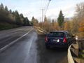
On the shoulder of US 30 between Portland and Scappoose.
Participants
Expedition
I used this expedition as an excuse to go for a run in Scappoose. Along the way, I stopped at the side of the road to collect my first hashpoint since March 2019. I never like to let a thousand days go by between hashpoints.
UPDATE: It says here that I've been out as recently as August 2019. And here I thought all this wiki data was gone for good!
Photos
On the side of the road.
