Difference between revisions of "2011-01-08 51 0"
imported>Sourcerer m (→Photo Gallery) |
imported>Sourcerer |
||
| Line 1: | Line 1: | ||
| − | |||
| − | |||
| − | |||
| − | |||
{{meetup graticule | {{meetup graticule | ||
| lat=51 | | lat=51 | ||
| Line 8: | Line 4: | ||
| date=2011-01-08 | | date=2011-01-08 | ||
| graticule_name=London East | | graticule_name=London East | ||
| − | | graticule_link=London East, United Kingdom}} | + | | graticule_link=London East, United Kingdom |
| + | }} | ||
| + | |||
| + | == Location == | ||
| + | |||
| + | Hucking. Be careful how you enunciate that one. Hucking lies between Maidstone and Sittingbourne, Kent, UK. | ||
== Participants == | == Participants == | ||
| Line 22: | Line 23: | ||
To be uploaded ... | To be uploaded ... | ||
| − | <gallery | + | <gallery> |
Image:2011-01-08_51_0_Sourcerer_1.jpg|Garmin Mapsource Track View. | Image:2011-01-08_51_0_Sourcerer_1.jpg|Garmin Mapsource Track View. | ||
Image:2011-01-08_51_0_Sourcerer_2.jpg|Google Earth Track View. | Image:2011-01-08_51_0_Sourcerer_2.jpg|Google Earth Track View. | ||
| Line 32: | Line 33: | ||
{{expedition summaries|2011-01-08}} | {{expedition summaries|2011-01-08}} | ||
| + | [[Category:Expeditions]] | ||
[[Category:Expeditions with photos]] | [[Category:Expeditions with photos]] | ||
[[Category:Coordinates reached]] | [[Category:Coordinates reached]] | ||
| − | |||
| − | |||
Revision as of 15:12, 22 August 2012
| Sat 8 Jan 2011 in London East: 51.2864810, 0.6481846 geohashing.info google osm bing/os kml crox |
Contents
Location
Hucking. Be careful how you enunciate that one. Hucking lies between Maidstone and Sittingbourne, Kent, UK.
Participants
Expedition
Neil was spending the weekend in Kent and this hashpoint was only a few miles from base. The hashpoint was a "Woodland Trust" foxglove glade right beside a forest track in an area, open to the public. You had to be careful where you trod to avoid damaging next summer's foxglove flowers. The whole area is being managed to preserve unique North Downs habitats. Situated on the top of the North Downs, there were fantastic views, both north over the Thames estuary and south over the Weald of Kent. The ground was wet and slippery after the melting of recent ice and snow and squally showers on the day. Leeds Castle is close by as well as the historic village of Hollingbourne.
Photo Gallery
To be uploaded ...
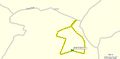
Garmin Mapsource Track View.
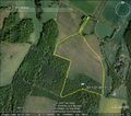
Google Earth Track View.
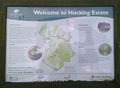
Photo of the public information sign.


Other geohashing expeditions on the same day
Expeditions and Plans
| 2011-01-08 | ||
|---|---|---|
| Colorado Springs, Colorado | Nathan Powell, Kirsten Rapp, James Solomon II | 2400 W 22nd St, Pueblo, CO 81003, USA (38.28648, -104.64818) 37.4 miles awa... |
| Cedar Rapids South, Iowa | phogan | In a farm field off a gravel road outside Washington, Iowa. |
| McMinnville, Oregon | APR | In the coast range about 3 miles off of the road through the nearest pass, ... |
| Linz, Austria | Masterbase, FotoJunky | A field in Allerheiligen im Mühlkreis, Austria |
| London East, United Kingdom | Sourcerer | Hucking. Be careful how you enunciate that one. Hucking lies between Maidst... |