Difference between revisions of "2016-06-28 52 1"
imported>Sourcerer (→Planning) |
imported>Sourcerer m (→New expedition) |
||
| Line 9: | Line 9: | ||
== Location == | == Location == | ||
| − | On | + | On Short Thorn Road, Horsford, Norfolk, UK. |
== Participants == | == Participants == | ||
| Line 21: | Line 21: | ||
== Expedition == | == Expedition == | ||
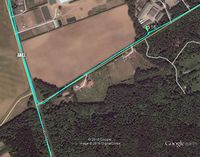
| − | + | This was a road hashpoint. The GPSr image shows 3 metres but it dropped to 1 and climbed back to 3 before I managed the evidence photo. There was no need to get out of the car. My time planning was spot on. Real life took a bit longer than expected. It took longer than normal to walk the dog before setting out and I added 4.5 km to my journey by missing a turning. It's fun to get the proof photo at 00:00 local time but no luck today. The 3G signal was too weak to upload any live data. I did get a partial map download before it failed. | |
== Photos == | == Photos == | ||
<gallery caption="Photo Gallery" widths="200px" heights="200px" perrow="3"> | <gallery caption="Photo Gallery" widths="200px" heights="200px" perrow="3"> | ||
| + | Image:2016-06-28 52 1 Sourcerer Proof.jpg | Proof | ||
| + | Image:2016-06-28 52 1 Sourcerer.jpg | Google Earth Track | ||
</gallery> | </gallery> | ||
| Line 45: | Line 47: | ||
}} | }} | ||
| − | |||
| − | |||
[[Category:Expeditions]] | [[Category:Expeditions]] | ||
[[Category:Expeditions with photos]] | [[Category:Expeditions with photos]] | ||
[[Category:Coordinates reached]] | [[Category:Coordinates reached]] | ||
| − | |||
Revision as of 00:39, 28 June 2016
| Tue 28 Jun 2016 in Norwich, UK: 52.7241148, 1.2321891 geohashing.info google osm bing/os kml crox |
Location
On Short Thorn Road, Horsford, Norfolk, UK.
Participants
Plans
Two of two spanning midnight - 2016-06-27 52 1 - 2016-06-28 52 1 - ETA 00:00.
Expedition
This was a road hashpoint. The GPSr image shows 3 metres but it dropped to 1 and climbed back to 3 before I managed the evidence photo. There was no need to get out of the car. My time planning was spot on. Real life took a bit longer than expected. It took longer than normal to walk the dog before setting out and I added 4.5 km to my journey by missing a turning. It's fun to get the proof photo at 00:00 local time but no luck today. The 3G signal was too weak to upload any live data. I did get a partial map download before it failed.
Photos
- Photo Gallery
Achievements
Sourcerer earned the Midnight Geohash achievement
|
Expeditions and Plans
| 2016-06-28 | ||
|---|---|---|
| Manhattan, Kansas | thunk | Northeast of Clay Center on the way to the nearby globalhash |
| Concord, New Hampshire | Mcbaneg, Katja, Rebekah, Sylvia | Wooded hillside in Alexandria, NH |
| Alert Bay, British Columbia | dunstergirl | On the ocean somewhere south of Donegal Head on Malcolm Island, a bit west ... |
| Norwich, United Kingdom | Sourcerer | On Short Thorn Road, Horsford, Norfolk, UK. |
| Gävle, Sweden | FelixTheCat | In a forest in Gävle, Sweden. |
| Globalhash | thunk | Near Crab Orchard, Johnson County, Nebraska, USA, in the middle of a (legum... |
Sourcerer's Expedition Links
2016-06-27 52 1 - 2016-06-28 52 1 - 2016-06-29 52 1 - KML file download of Sourcerer's expeditions for use with Google Earth.

