Difference between revisions of "2017-03-16 52 1"
From Geohashing
imported>Sourcerer m ([live picture] Couch. [http://www.openstreetmap.org/?lat=52.36859143&lon=1.59530818&zoom=16&layers=B000FTF @52.3686,1.5953]) |
imported>Sourcerer m (→New expedition) |
||
| Line 1: | Line 1: | ||
| − | + | {{meetup graticule | |
| − | |||
| − | |||
| − | |||
| − | |||
| − | |||
| − | |||
| − | |||
| − | |||
| − | |||
| − | {{meetup graticule | ||
| lat=52 | | lat=52 | ||
| lon=1 | | lon=1 | ||
| date=2017-03-16 | | date=2017-03-16 | ||
| + | | graticule_name=Norwich, UK | ||
| + | | graticule_link=Norwich, United Kingdom | ||
}} | }} | ||
| − | |||
| − | |||
__NOTOC__ | __NOTOC__ | ||
| + | == Location == | ||
| − | + | A roadside point between Stoven and Uggeshall, Suffolk, UK. | |
| − | |||
== Participants == | == Participants == | ||
| − | + | ||
| − | + | [[User:Sourcerer|Sourcerer]] | |
== Plans == | == Plans == | ||
| − | + | ||
| + | Two of two spanning midnight - [[2017-03-15 52 1]] - [[2017-03-16 52 1]] - ETA 00:00. | ||
== Expedition == | == Expedition == | ||
| − | |||
| − | + | There was roadside parking and a park bench right beside the hashpoint. This was odd because the location was away from any centres of population. It was a beautiful moonlit night but too cold to sit and admire the view. My proof photo was taken just before midnight and uploaded to the wiki just after. | |
| − | |||
| − | |||
| − | |||
| − | |||
| − | |||
| − | |||
| − | |||
| + | == Photos == | ||
| + | <gallery caption="Gallery" widths="200px" heights="200px" perrow="3"> | ||
Image:2017-03-16_52_1_Sourcerer_1489622283123.jpg | Arrived. [http://www.openstreetmap.org/?lat=52.36859143&lon=1.59530818&zoom=16&layers=B000FTF @52.3686,1.5953] | Image:2017-03-16_52_1_Sourcerer_1489622283123.jpg | Arrived. [http://www.openstreetmap.org/?lat=52.36859143&lon=1.59530818&zoom=16&layers=B000FTF @52.3686,1.5953] | ||
| − | |||
Image:2017-03-16_52_1_Sourcerer_1489622319827.jpg | Couch. [http://www.openstreetmap.org/?lat=52.36859143&lon=1.59530818&zoom=16&layers=B000FTF @52.3686,1.5953] | Image:2017-03-16_52_1_Sourcerer_1489622319827.jpg | Couch. [http://www.openstreetmap.org/?lat=52.36859143&lon=1.59530818&zoom=16&layers=B000FTF @52.3686,1.5953] | ||
| + | Image:2017-03-16_52_1_Sourcerer.jpg | Google Earth Track | ||
</gallery> | </gallery> | ||
== Achievements == | == Achievements == | ||
{{#vardefine:ribbonwidth|800px}} | {{#vardefine:ribbonwidth|800px}} | ||
| − | |||
| − | + | {{Midnight geohash | |
| − | + | | latitude = 52 | |
| − | + | | longitude = 1 | |
| + | | date = 2017-03-16 | ||
| + | | name = Sourcerer | ||
| + | }} | ||
| − | + | {{Sourcerer_links | |
| + | | prev = 2017-03-15 52 1 | ||
| + | | curr = 2017-03-16 52 1 | ||
| + | | next = 2017-03-17 52 1 | ||
| + | | date = 2017-03-16 | ||
| + | }} | ||
| − | |||
| − | |||
| − | |||
| − | |||
| − | |||
| − | |||
| − | |||
| − | |||
[[Category:Expeditions]] | [[Category:Expeditions]] | ||
| − | |||
[[Category:Expeditions with photos]] | [[Category:Expeditions with photos]] | ||
| − | |||
| − | |||
| − | |||
| − | |||
| − | |||
[[Category:Coordinates reached]] | [[Category:Coordinates reached]] | ||
| − | |||
| − | |||
| − | |||
| − | |||
| − | |||
| − | |||
| − | |||
| − | |||
| − | |||
| − | |||
| − | |||
| − | |||
| − | |||
| − | |||
| − | |||
| − | |||
| − | |||
| − | |||
Revision as of 01:10, 16 March 2017
| Thu 16 Mar 2017 in Norwich, UK: 52.3685911, 1.5953261 geohashing.info google osm bing/os kml crox |
Location
A roadside point between Stoven and Uggeshall, Suffolk, UK.
Participants
Plans
Two of two spanning midnight - 2017-03-15 52 1 - 2017-03-16 52 1 - ETA 00:00.
Expedition
There was roadside parking and a park bench right beside the hashpoint. This was odd because the location was away from any centres of population. It was a beautiful moonlit night but too cold to sit and admire the view. My proof photo was taken just before midnight and uploaded to the wiki just after.
Photos
- Gallery
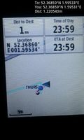
Arrived. @52.3686,1.5953
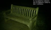
Couch. @52.3686,1.5953
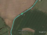
Google Earth Track


Achievements
Sourcerer earned the Midnight Geohash achievement
|
Expeditions and Plans
| 2017-03-16 | ||
|---|---|---|
| München, Germany | Solli | On the Highway A9 between Allershausen and Kreuz Neufahrn in southern direc... |
| Mannheim, Germany | DODO | On a wheat field next to Oftersheim. |
| Kassel, Germany | GeorgDerReisende | The hash lay on a fieldway north of Landwehrhagen. |
| Norwich, United Kingdom | Sourcerer | A roadside point between Stoven and Uggeshall, Suffolk, UK. |
Sourcerer's Expedition Links
2017-03-15 52 1 - 2017-03-16 52 1 - 2017-03-17 52 1 - KML file download of Sourcerer's expeditions for use with Google Earth.