Difference between revisions of "2009-06-26 50 11"
imported>FippeBot m (Location) |
m (Replacing http://wiki.xkcd.com/wgh/images/20090625-51N12E_02.jpg with {{filepath:20090625-51N12E_02.jpg}}) |
||
| Line 26: | Line 26: | ||
Image:Geo_20090626_50_11_3.jpg|"Marking the spot" - a little more obvious this time, so all later geohashers could find it. | Image:Geo_20090626_50_11_3.jpg|"Marking the spot" - a little more obvious this time, so all later geohashers could find it. | ||
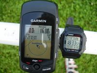
Image:Geo_20090626_50_11_4.jpg|Proof of coordinates and date. | Image:Geo_20090626_50_11_4.jpg|Proof of coordinates and date. | ||
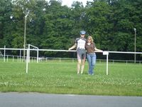
| − | Image:Geo_20090626_50_11_5.jpg|Manu and Reinhard at the hash that looks exactly like the one they visited [ | + | Image:Geo_20090626_50_11_5.jpg|Manu and Reinhard at the hash that looks exactly like the one they visited [{{filepath:20090625-51N12E_02.jpg}} the day before]. |
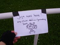
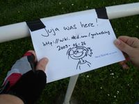
Image:Geo_20090626_50_11_6.jpg|Somebody was there before ... | Image:Geo_20090626_50_11_6.jpg|Somebody was there before ... | ||
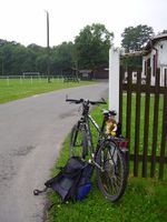
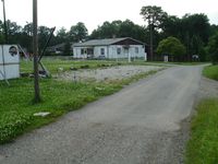
Image:Geo_20090626_50_11_7.jpg|That's where the road Reinhard was cycling on in January ended. The hash is right beside on the left. | Image:Geo_20090626_50_11_7.jpg|That's where the road Reinhard was cycling on in January ended. The hash is right beside on the left. | ||
Latest revision as of 12:53, 19 February 2020
| Fri 26 Jun 2009 in 50,11: 50.9886395, 11.7552430 geohashing.info google osm bing/os kml crox |
Participants
Report: Juja
First one! I had half a day off, so I started right after lunch - not because I was anxious to see the point, but because I was afraid of the thunderstorms the weather forecast had predicted for the later afternoon and evening. I am very sorry to have missed a possible meetup with Manu and Reinhard, but anyway, I went there and back without any rain!
I knew the way to Tautenburg already, and for the part I had to go to Rockau my inner compass seemed to be working, because I found the way right away and even was a little surprised when I came out of the forest and saw the place-name sign of Rockau in front of me. So I took some photos, and hopefully the old man in the wheel chair that I saw rolling around at some distance didn't destroy the note I left for Manu, Reinhard and maybe Uli. The way to Bürgel also was more or less guessing for me, but I was surprisingly right again and even found the bike way from Bürgel to Jena for my way home. Maybe this was my last tour without GPS (and without a map, too, because I forgot my beautiful new bike map at home)... :)
Report: Manu
The weekend began and so I was travelling from Leipzig to Thuringia again. Not far from the autobahn this geohash was located near the corner of a soccer field like the day before. So I drove a small detour and met Reinhard in Rockau, where he was already waiting for me. We added our names to the note Juja had left in the afternoon and then left for Jena. A really easy and quick geohash.
Report: Reinhard
I started from work in Jena at 17:45 to cycle the 16.9 km to the hashpoint. I got there at 18:22 and was waiting some minutes for Manu who I wanted to meet there. I noticed that I've been at the edge of this soccer field before, in January on a bike tour. (have a look at that trip here) It's really funny how this hashpoint lay exactly like the one we visited the day before near Leipzig: At the long side of a soccer field, a few meters outside and closer to the left goal.
- Photo Gallery
Manu and Reinhard at the hash that looks exactly like the one they visited the day before.
Awards
Juja earned the Earliest geohasher achievement
|
Juja and Reinhard earned the Bicycle geohash achievement
|
Reinhard earned the Déjà Vu Geohash Achievement
|
