Welcome
|
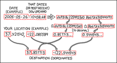
| Welcome to the Geohashing Community Wiki. Geohashing is a method for finding an effectively random location nearby and visiting it, i.e. a Spontaneous Adventure Generator. Geohashing was brought to you by the xkcd webcomic.
Every day, the algorithm generates a new set of coordinates for each 1°×1° latitude/longitude zone (known as a graticule) in the world. The coordinates can be anywhere -- in the forest, in a city, on a mountain, or even in the middle of a lake! Everyone in a given region gets the same set of coordinates relative to their graticule.
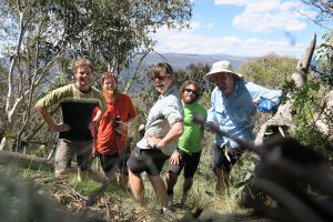
As such, these coordinates can be used as destinations for adventures, à la Geocaching, or for local meetups. After the fun, why not document your expedition? The rest of us would love to read your story, see your photos, and cheer your success (or commiserate with your failure). You can use this wiki to document the daily coordinates (geohashes) you’ve been to or tried to reach.
| Learn about Geohashing
|
Get involved
|
Disclaimer: When any coordinates generated by the Geohashing algorithm fall within a dangerous area, are inaccessible, or would require illegal trespass, DO NOT attempt to reach them. Please research each potential location before attempting to access it. You are expected to use proper judgment in all cases and are solely responsible for your own actions. See more guidelines.
|
Official xkcd meetups
|
|
Based on the title text from the comic that established geohashing, the "official" meetup day was interpreted as being Saturday; that is, the day one would have the best chance of meeting others -- see also Mouseover Day. Additionally it was decided through convention that a good meeting time would be 16:00 local time (4:00 P.M.)¹
However, neither of these are hard rules, and they were formulated at a very different early stage in the sport's history. Nowadays and for quite awhile actually, any date or time can be good (or bad, depending on how many other hashers are near you) for meeting up, especially if prearranged. Note that this only applies to that day’s normal local geohash or globalhash coordinates, if you try to go to an alternate location without telling anyone else, it's highly unlikely you'd meet up with a hasher there (obviously).
¹Or earlier if that would be too close to sunset during the winter, or other quirks of temporal tradition; see your local graticule page for consensus there.
|
|
|
|
|
Coordinates
|
|
The coordinates for the next Saturday meetups, scheduled for 30 November 2024, will be based on the Dow’s opening price published at 09:30 EST (14:30 UTC) on Friday 29 November. See timeanddate.com to convert this time to your local time zone.
| Date
|
West of –30°
|
East of –30°
|
| Fri 11 Jul 2008
|
.5661950, .5300921
|
.4231424, .7694640
|
| Thu 10 Jul 2008
|
.5661950, .5300921
|
.4231424, .7694640
|
| Wed 9 Jul 2008
|
.5661950, .5300921
|
.4231424, .7694640
|
| Tue 8 Jul 2008
|
.5661950, .5300921
|
.4231424, .7694640
|
| Mon 7 Jul 2008
|
.5661950, .5300921
|
.4231424, .7694640
|
| Sun 6 Jul 2008
|
.5661950, .5300921
|
| Sat 5 Jul 2008
|
.5661950, .5300921
|
| Fri 4 Jul 2008
|
.5661950, .5300921
|
View expedition archives for: November 2024 | October 2024 | September 2024 | More...
|
Find others in your area!
|
Want to find geohashers in your local area? See Category:Active Graticules for a list of graticules with active users in them.
- Don't see your home area? Follow the format and create a page for it! We'd love to have you!
- An interactive map is available for Google Earth or on Google Maps.
- You can also attach your photos to this Google Maps layer.
|
Implementations
|
| A full list of reference and practical implementations can be found on the Implementations page.
|
|
