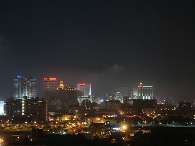
Atlantic City, New Jersey
| Philadelphia, PA (North) | Newark | New York, NY |
| Philadelphia, PA (South) | Atlantic City, New Jersey | – |
| Salisbury, MD | Cape May | – |
[[Category:Meetup in {{{lat}}} {{{lon}}}| ]]
The Atlantic City graticule is at 39 N, -74 W. It encloses nearly all of South Jersey, including the majority of the Jersey Shore, from Dover Beaches and Seaside Heights to North Wildwood. Roughly a third of this graticule is in the Atlantic Ocean. A small chunk of Delaware Bay is also enclosed.
Contents
Places in this Graticule
Cities
- Atlantic City, NJ
- Toms River, NJ
- Ocean City, NJ
- Marlton, NJ (A suburb of Camden)
- near Philadelphia, PA
- Fort Dix, NJ (split)
State parks & wildlife areas
Local Geohashers
Not-so-local Geohashers
- Jevanyn passes through on his way to Cape May.
Attempted geohashes
- August 23, 2008
- Jevanyn took a ride on his uncle's boat around Wildwood, and cruised right past a water geohash, not knowing it was there.
- August 16, 2008
- Jevanyn got within photo range of a water geohash near Exit 30 on the Parkway.
Daily Locations
Older locations have been archived.
- 8/31/08
Down the end of Broadway, in Somers Point. Did you know? that Great Egg Harbor got its names because it was a good place to find birds' eggs?
- 8/30/08 - Saturday
The AC geohash is waaaay out in the ocean. So go to Six Flags Great Adventure with the North Jersey geohashers instead.
- 8/29/08
Undeveloped land along Rte 539, south of Warren Grove. Looks like some kind of private airstrip a bit further southwest. And why is that pond near town so blue?
- 8/27/08
The Philly geohash is along a creek south of Cole Mills Road, east of Franklinville.
- 8/26/08
Undeveloped woodland along Route 49, between Tuckahoe and Cumberland.
- 8/25/08
![]() A half-mile off the beach near Avalon.
A half-mile off the beach near Avalon.
- 8/21/08
Near E. Maple Shade Ln. and (another road sign I want a picture of) Dirt Rd., Beasleys Point.
- 8/20/08
![]() Off the coast near Lavallette and Mantoloking.
Off the coast near Lavallette and Mantoloking.
Patcong Creek, near Parkway Exit 30, Steelmanville.
- 8/14/08
![]() Three miles offshore near Beach Haven.
Three miles offshore near Beach Haven.
- 8/12/08
- 8/11/08
![]() Just off the coast near Lavallette.
Just off the coast near Lavallette.
The Philly geohash is on the front walk of a house on Park Avenue, in the Iron Hill neighborhood. Right up Haddonfield Rd from the Cherry Hill Mall.
- 8/10/08
On the bank of a fairly small lake, across Raritan Ave from Atsion Lake, in Wharton State Forest. The closest town is Parkdale to the south.
- 8/8/08
![]() Undeveloped woodland near Broad Lane, near West Fleming Pike / Winslow Road. AC Expwy exit 33 (southbound only).
Undeveloped woodland near Broad Lane, near West Fleming Pike / Winslow Road. AC Expwy exit 33 (southbound only).
- 8/7/08
![]() A farmer's field along the Atlantic City Expressway, near NJ 54 (AC Expwy Exit 28).
A farmer's field along the Atlantic City Expressway, near NJ 54 (AC Expwy Exit 28).
- 8/6/08
The Philadelphia (South) geohash is on Fries Mill Road, north of the town of Fries Mill and southeast of Glassboro. Maybe he's related to the guy on Futurama?
- 8/5/08
Horicon Road, Cedar Glen Lakes. Just east of Fort Dix.
- 8/4/08
The Philadelphia (South) geohash is just off NW Blvd in Vineland.
