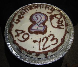
2010-05-21 49 -122
Welcome to the official wiki page of the Vancouver graticule's Second Annual Geohashing Day celebration. If you enjoy this account you may also be interested in reading about the following day's Mouseover Day festivities.
| Fri 21 May 2010 in 49,-122: 49.2624552, -122.4351431 geohashing.info google osm bing/os kml crox |
Location
A short bushwhack from a logging road between Dewdney Trunk Road and Alouette Lake. Quality of the logging road is unknown. Google maps street view shows an open gate across the access to the road, so we knew there was a small chance that the road would be gated, thus arrived prepared for a 4 km walk from the known good roads.
Participants
Is there some way to make the participants list into two columns? Vancouver is seriously going to need that at this rate.
Plans
For Vancouverites the Geohashing Day coordinates are released at 6:30 a.m. the same day, so the first meetup was at hash o'clock sharp in the #geohashing channel. Geohashing Day meetup point selection prefers an attempt at the actual coordinates for the day, but while Vancouver's was in the middle of the water, Surrey's was close enough to civilization that it was easily chosen as our destination.
Planning from there was confusing and fluid, involving five different vehicles, one of which didn't exist and three of which were eventually used, four different pick-up locations for people in at least three cities, about seven different proposed departure times, buses and SkyTrain.
Sample Conversation
Rhonda has just agreed to meet pi at Waterfront Station at 16:10, then take the Skytrain to Yaletown where they will rendezvous with Wade and Rhonda's car at 16:30. The wiki has been updated with this plan.
- Xore has joined #geohashing
- <Xore> Wade, I'm going to drive my car to work and then we can leave about 4:30 to go to the geohash.
- <Wade> Sounds like a plan.
- <Robyn> Or you could go with the other plan on the wiki that we already made. Rhonda is bringing her car.
Robyn is informed that "Rhonda's car" and "Xore's car" is the same vehicle.
- <Wade> I told you it sounded like a plan. In fact it sounded like THE plan, but I wasn't going to say that.
We struggled to adhere to the principle of geohashing as a mostly unplanned mass meet-up, while balancing the desire to use transit and carpool rather than single-occupant vehicles, and acknowledging the fact that most of the group has to work on a Friday, in one case until seven p.m. That's the sort of thing Mouseover Day was created to address, but this graticule strives to overcome such petty barriers at darkness and gravity. The final roster was something like this:
Vehicle 1 (Rhonda)
- Rhonda and pi meet at Waterfront Station at 16:10
- Travel via Canada line Skytrain to Yaletown station, near the car
- Leaves downtown at 16:30
- Contains: Rhonda, pi, Xore, Wade
Vehicle 2 (Arbron)
- Leaves UBC CS Building at 19:00 (between X-wing and Dempster).
- Contains: Robyn, Arbron, srs0, Elbie
Vehicle 3 (Yang)
- Left North Coquitlam around 18:30
- Yang and new geohashers Kyle and Denise
Expedition
Temporary Summary
All eleven participants hiked four kilometres each way, ate cake, and returned safely to the car. Details withheld because we want to get a little bit of sleep before tomorrow's Mouseover Day festivities.
