Difference between revisions of "2009-02-04 49 12"
imported>Dawidi (writeup (pics and video to follow)) |
imported>FippeBot m (Location) |
||
| (3 intermediate revisions by 2 users not shown) | |||
| Line 17: | Line 17: | ||
However, before turning around, I mounted the time-lapse camera (previously seen in [[2009-01-31 48 12]]) to the back of my bike bag and recorded the full ride back to the office, where I arrived at 10:30. | However, before turning around, I mounted the time-lapse camera (previously seen in [[2009-01-31 48 12]]) to the back of my bike bag and recorded the full ride back to the office, where I arrived at 10:30. | ||
| − | Parking my bike there, I noticed a crust of ice from the freezing fog had accumulated on all forward surfaces on my bike and jacket, even on my GPS. | + | Parking my bike there, I noticed a crust of ice from the freezing fog had accumulated on all forward surfaces on my bike and jacket, even on my GPS. (Insofar it was fortunate that the camera was looking back from my bag, and not facing the front...) |
| − | ( | + | '''Here's the video: [http://vimeo.com/3084981 on Vimeo (high quality)] or [http://www.youtube.com/watch?v=fLZ4B_xT1Nc on Youtube]''' |
| + | <gallery> | ||
| + | Image:2009-02-04 49 12 slippery.jpg | Too slippery to continue :-/ | ||
| + | Image:2009-02-04 49 12 ice.jpg | Frozen stuff below the thick ice. | ||
| + | Image:2009-02-04 49 12 not even close.jpg |3.3km to go - not even close. | ||
| + | </gallery> | ||
[[Category:Expeditions]] | [[Category:Expeditions]] | ||
[[Category:Expeditions with photos]] | [[Category:Expeditions with photos]] | ||
[[Category:Coordinates not reached]] | [[Category:Coordinates not reached]] | ||
| − | [[Category: | + | [[Category:Not reached - Mother Nature]] |
| + | {{location|DE|BY|R}} | ||
Latest revision as of 01:42, 8 August 2019
| Wed 4 Feb 2009 in 49,12: 49.0505257, 12.3319136 geohashing.info google osm bing/os kml crox |
Up in a larger mountainous forest area, 5km north of Bach an der Donau, about 25km east of Regensburg. Probably an idyllic place several kilometers from the next village.
dawidi
I left only around 7:20 in the morning, instead of 6:00 as I had planned, and cycled to Bach an der Donau through the freezing fog. After giggling at the roadsign "Kittenrainstraße" I had already seen during the 2008-10-18 49 12 expedition, I arrived at the end of "Sturmmühlweg", on the edge of the forest area, at around 9:00.
I found the path leading up into the forest covered with a clear, solid layer of at least 2cm of very slippery ice, and after a few meters for testing how well I could push my bike on this surface, I decided to call it a failure instead of spending all day inching my way to the hash and quite certainly slipping and hurting myself in the process.
However, before turning around, I mounted the time-lapse camera (previously seen in 2009-01-31 48 12) to the back of my bike bag and recorded the full ride back to the office, where I arrived at 10:30.
Parking my bike there, I noticed a crust of ice from the freezing fog had accumulated on all forward surfaces on my bike and jacket, even on my GPS. (Insofar it was fortunate that the camera was looking back from my bag, and not facing the front...)
Here's the video: on Vimeo (high quality) or on Youtube
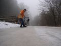
Too slippery to continue :-/
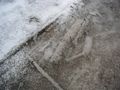
Frozen stuff below the thick ice.
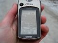
3.3km to go - not even close.


