Difference between revisions of "2009-07-24 -36 146"
imported>Felix Dance (→Felix Dance) |
m (More specific location) |
||
| (9 intermediate revisions by 2 users not shown) | |||
| Line 11: | Line 11: | ||
== Who went == | == Who went == | ||
| + | |||
| + | *[[User:Felix Dance|Felix Dance]] | ||
| + | *[[User:Stevage|Stevage]] | ||
| + | *Mitch | ||
| + | *[[User:Sashazeg|Sashazeg]] | ||
| + | *Adam | ||
=== Felix Dance === | === Felix Dance === | ||
| − | Stevage, I and others were hanging out at the Bright Brewery on our way home after a week of skiing and boarding at Mount Hotham and Falls Creek when we discovered the hash point location. It was an extremely doable location pretty much on the highway we were planning to drive home on, just before the turnoff to the Hume. | + | Stevage, I and others were hanging out at the Bright Brewery on our way home after a week of skiing and boarding at Mount Hotham and Falls Creek when we discovered the hash point location. It was an extremely doable location pretty much on the highway we were planning to drive home on, just before the turnoff to the Hume. We were especially eager to get to this one as we'd failed the one on the way up in [[2009-07-17 -36 146|Bright]]. |
On the drive I got out my GPS and counted down the kms. Strangely, when we got there, the GPS indicated that the point was on the right (north) side of the road rather than the south as shown on the Google Maps image. I'd come across this discrepancy before at the Craigieburn hashpoint ([[2009-07-08 -38 145]]) - I can't imagine that my GPS could be inaccurate, so I'll have to assume that the mapping of the point is on the fritz these days. | On the drive I got out my GPS and counted down the kms. Strangely, when we got there, the GPS indicated that the point was on the right (north) side of the road rather than the south as shown on the Google Maps image. I'd come across this discrepancy before at the Craigieburn hashpoint ([[2009-07-08 -38 145]]) - I can't imagine that my GPS could be inaccurate, so I'll have to assume that the mapping of the point is on the fritz these days. | ||
| Line 24: | Line 30: | ||
== Photos == | == Photos == | ||
| − | <gallery perrow=" | + | <gallery perrow="6"> |
| + | Image:Adamclimbingfence20090724s36e146.jpg|Adam climbing the fence to the geohash | ||
| + | Image:Carparkedatgeohash20090724s36e146.JPG|Car parked near geohash location on Alpine Highway | ||
| + | Image:Cowpatathashpoint20090724s36e146.JPG|Cow pat at the 'exact' geohash location | ||
| + | Image:Felixfindingdirection20090724s36e146.JPG|Felix finding the direction to the geohash | ||
| + | Image:FelixMitchSashaAdam20090724s36e146.JPG|Felix, Mitch, Sasha and Adam at the geohash locatian | ||
| + | Image:FelixSteve20090724s36e146.jpg|Felix and Steve at the geohash location | ||
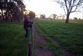
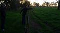
| + | Image:FenceJumping20090724s36e146.JPG|Felix jumping over the fence for the geohash location | ||
| + | Image:GPSatgeohash20090724s36e146.JPG|Proof at the geohash location | ||
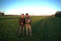
| + | Image:MitchAdamFelix20090724s36e146.JPG|Mitch, Adam and Felix at the geohash location | ||
| + | Image:Standingathashpoint20090724s36e146.JPG|Standing at the geohash location | ||
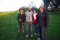
| + | Image:SteveFelixMitchSashaAdam20090724s36e146.JPG|Steve, Felix, Mitch, Sasha and Adam at the geohash location | ||
| + | Image:Sunsetatgeohash20090724s36e146.JPG|Sunset at the geohash location | ||
| + | </gallery> | ||
| − | + | == Achievement == | |
| + | |||
| + | {{Easy_geohash | ||
| + | |||
| + | | latitude = -36 | ||
| + | | longitude = 146 | ||
| + | | date = 2009-07-24 | ||
| + | | name = Steve, Felix, Mitch, Sasha and Adam | ||
| + | | image = Carparkedatgeohash20090724s36e146.JPG | ||
| + | }} | ||
[[Category:Expeditions]] | [[Category:Expeditions]] | ||
[[Category:Coordinates reached]] | [[Category:Coordinates reached]] | ||
[[Category:Expeditions with photos]] | [[Category:Expeditions with photos]] | ||
| + | {{location|AU|VIC|WG}} | ||
Latest revision as of 11:47, 1 August 2020
| Fri 24 Jul 2009 in -36,146: -36.3783235, 146.3920876 geohashing.info google osm bing/os kml crox |
The Place
Just off the Alpine Highway coming in to Wangaratta from the mountains.
Who went
- Felix Dance
- Stevage
- Mitch
- Sashazeg
- Adam
Felix Dance
Stevage, I and others were hanging out at the Bright Brewery on our way home after a week of skiing and boarding at Mount Hotham and Falls Creek when we discovered the hash point location. It was an extremely doable location pretty much on the highway we were planning to drive home on, just before the turnoff to the Hume. We were especially eager to get to this one as we'd failed the one on the way up in Bright.
On the drive I got out my GPS and counted down the kms. Strangely, when we got there, the GPS indicated that the point was on the right (north) side of the road rather than the south as shown on the Google Maps image. I'd come across this discrepancy before at the Craigieburn hashpoint (2009-07-08 -38 145) - I can't imagine that my GPS could be inaccurate, so I'll have to assume that the mapping of the point is on the fritz these days.
Anyway, we had a car of 5 people and when we parked by the side of the road, 80m from the point, we all climbed over the barbed wire fence (it's not trespassing if we're not asked to leave - otherwise how would milk bars operate?) and very quickly located the exact location of the geohash.
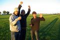
We stood around like idiots for a while, photographing each other, the GPS and the cowpat we'd decided was the exact location, whilst taking in the verdant surrounds and pre-sunset light before jumping back over the fence and cramming back into the car. This was the first geohash for three people: Sasha, Adam and Mitchell.
Photos
Adam climbing the fence to the geohash
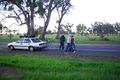
Car parked near geohash location on Alpine Highway
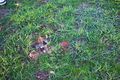
Cow pat at the 'exact' geohash location
Felix finding the direction to the geohash
Felix, Mitch, Sasha and Adam at the geohash locatian
Felix and Steve at the geohash location
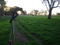
Felix jumping over the fence for the geohash location
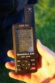
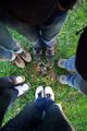
Proof at the geohash location
Mitch, Adam and Felix at the geohash location
Standing at the geohash location

Steve, Felix, Mitch, Sasha and Adam at the geohash location
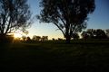
Sunset at the geohash location


Achievement
Steve, Felix, Mitch, Sasha and Adam has visited an Easy Geohash
|