Difference between revisions of "2009-08-22 52 13"
imported>Davidc (→Expedition) |
imported>FippeBot m (Location) |
||
| (5 intermediate revisions by 2 users not shown) | |||
| Line 1: | Line 1: | ||
| − | |||
| − | |||
| − | |||
| − | |||
{{meetup graticule | {{meetup graticule | ||
| lat=52 | | lat=52 | ||
| Line 9: | Line 5: | ||
}} | }} | ||
| − | |||
__NOTOC__ | __NOTOC__ | ||
== Location == | == Location == | ||
| Line 30: | Line 25: | ||
== Expedition == | == Expedition == | ||
| − | + | *waiting for davidc, someone leaving the town just gave me a free concert ticket. woo for nice people. -- [[User:relet|relet]] 08:29, 22 August 2009 (UTC) | |
| − | |||
| − | *waiting for davidc, someone leaving the town | ||
| − | |||
| − | |||
=== relet and davidc === | === relet and davidc === | ||
| Line 44: | Line 35: | ||
At 12:00 we arrived and had a brief argument over the exact hash point - relet was using pure GPS and davidc was also using the overhead satellite map - when Trurl turned up on his bicycle and added a third GPS to the argument. Compromising on one side of the track, the obligatory silly grin photo was taken. | At 12:00 we arrived and had a brief argument over the exact hash point - relet was using pure GPS and davidc was also using the overhead satellite map - when Trurl turned up on his bicycle and added a third GPS to the argument. Compromising on one side of the track, the obligatory silly grin photo was taken. | ||
| − | davidc then headed over to the other side of the field to the geocache [http://coord.info/GC15NT8 GC15NT8 An den Mahlower Fishteichen]. relet and Trurl stayed behind to take a photo. You can just about make davidc out in the red geohashing shirt across the field, thus proving line of sight for the ribbon. Further proof is shown on this [http://www.movable-type.co.uk/scripts/latlong-map.html?lat1=52.37166666666667&long1=13.374033333333333&lat2=52.3733159&long2=13.3712666 point to point map]. The logbook was duly signed and a red herring geocoin swiped. | + | davidc then headed over to the other side of the field to the geocache [http://coord.info/GC15NT8 GC15NT8 An den Mahlower Fishteichen]. This earned us the [[Hash collision achievement]]. relet and Trurl stayed behind to take a photo. You can just about make davidc out in the red geohashing shirt across the field, thus proving line of sight for the ribbon. Further proof is shown on this [http://www.movable-type.co.uk/scripts/latlong-map.html?lat1=52.37166666666667&long1=13.374033333333333&lat2=52.3733159&long2=13.3712666 point to point map]. The logbook was duly signed and a red herring geocoin swiped. |
Trurl headed back home, so davidc and relet picked up another geocache, [http://coord.info/GC1TB41 GC1TB41 Mahlower See], before ploughing into the forest with great abandon, attempting to find a direct route back to the car. Bravado gave way however to caution when a field of dense nettles forced the shorts-wearing davidc to stop. Returning to a field we found a better route, picked up [http://coord.info/GCH9NW GCH9NW Fuschbau] and returned to the car. | Trurl headed back home, so davidc and relet picked up another geocache, [http://coord.info/GC1TB41 GC1TB41 Mahlower See], before ploughing into the forest with great abandon, attempting to find a direct route back to the car. Bravado gave way however to caution when a field of dense nettles forced the shorts-wearing davidc to stop. Returning to a field we found a better route, picked up [http://coord.info/GCH9NW GCH9NW Fuschbau] and returned to the car. | ||
Back at Hauptbahnhof, we visited [http://coord.info/GCZCQ7 GCZCQ7 Berlin's Bahnhof] before parting ways. davidc remained to pick up antihistamine cream for all his bites and stings, and then did himself proud finding [http://coord.info/GCWEFD GCWEFD Berlin-Hauptbahnhof] in broad daylight with thousands of people around, deftly timing his leap over a fence to avoid being seen by the many stationed police, and dropping down and across under a bridge. | Back at Hauptbahnhof, we visited [http://coord.info/GCZCQ7 GCZCQ7 Berlin's Bahnhof] before parting ways. davidc remained to pick up antihistamine cream for all his bites and stings, and then did himself proud finding [http://coord.info/GCWEFD GCWEFD Berlin-Hauptbahnhof] in broad daylight with thousands of people around, deftly timing his leap over a fence to avoid being seen by the many stationed police, and dropping down and across under a bridge. | ||
| + | |||
| + | === Jerrome === | ||
| + | |||
| + | Jerrome arrived at the spot somewhat late, about 1620. Using a GPS device intended for a bicycle on a motorbike prooved to be a little more difficult than previously thought. Almost lost my hat, too. Found the markers left behind by relet and davidc. | ||
== Tracklog == | == Tracklog == | ||
| Line 57: | Line 52: | ||
<gallery> | <gallery> | ||
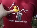
| + | Image:2009-08-22_52_13_P1040589.JPG|davidc in his new shirt | ||
| + | Image:2009-08-22_52_13_P1040591.JPG | Berliner Mauerweg - the Wall was here. | ||
| + | Image:2009-08-22_52_13_P1040592.JPG | As you are informed by this map | ||
| + | Image:2009-08-22_52_13_P1040593.JPG | davidc leading the way | ||
| + | Image:2009-08-22_52_13_P1040594.JPG | relet, following... | ||
| + | Image:2009-08-22_52_13_P1040595.JPG | ...wherever davidc's iPhone was pointing. | ||
| + | Image:2009-08-22_52_13_P1040596.JPG | We could have taken this path instead. :P | ||
Image:2009-08-22 52 13 hashtree.JPG|right to left: [[user:relet|relet]]; [[user:Trurl|Trurls]] hashbike; hashtree. | Image:2009-08-22 52 13 hashtree.JPG|right to left: [[user:relet|relet]]; [[user:Trurl|Trurls]] hashbike; hashtree. | ||
| − | Image:2009-08- | + | Image:2009-08-22_52_13_2009-08-22_12.09.44.jpg | Trurl summoning the coordinates in a Mayan GPS dance |
| − | + | Image:2009-08-22_52_13_P1040605.JPG | When he started this, we decided to skip on the other rituals involving blood offerings. | |
| − | Image:2009-08- | ||
| − | |||
Image:2009-08-22_52_13_IMG_0152.PNG|GPS coords proof | Image:2009-08-22_52_13_IMG_0152.PNG|GPS coords proof | ||
Image:2009-08-22_52_13_IMG_0153.PNG|Map proof | Image:2009-08-22_52_13_IMG_0153.PNG|Map proof | ||
| + | Image:2009-08-22_52_13_P1040603.JPG | Hashdroid proof. Accuracy is making fun of us, as usual. | ||
| + | Image:2009-08-22_52_13_P1040606.JPG | Stupid grin proof. | ||
| + | Image:2009-08-22_52_13_P1040604.JPG | Random trigger art. | ||
| + | Image:2009-08-22_52_13_2009-08-22_12.22.34.jpg | An invasion of geohashers! | ||
| + | Image:2009-08-22_52_13_P1040608.JPG | Indeed. | ||
| + | Image:2009-08-22_52_13_P1040613.JPG|[[user:davidc|davidc]] next to a geocache, seen from the geohash. | ||
| + | Image:2009-08-22_52_13_davidc_zoomed.JPG|... with a little zoom. | ||
| + | Image:2009-08-22_52_13_P1040631.JPG | What he really was trying to tell us. | ||
| + | Image:2009-08-22_52_13_P1040617.JPG | Davidc near the cache | ||
| + | Image:2009-08-22_52_13_P1040619.JPG | He didn't need help after all | ||
| + | Image:2009-08-22_52_13_P1040620.JPG | A red herring! | ||
| + | Image:2009-08-22_52_13_P1040621.JPG | The hash, seen from the cache | ||
| + | Image:2009-08-22 52 13 exit.JPG|relet and david hunting for more caches | ||
| + | Image:2009-08-22_52_13_P1040622.JPG | Are you sure this is the right field of nettles? | ||
| + | Image:2009-08-22_52_13_P1040623.JPG | Come on, you're almost as tall as they are. | ||
| + | Image:2009-08-22_52_13_P1040625.JPG | Corn fields are more walkable. | ||
| + | Image:2009-08-22_52_13_P1040626.JPG | Apples! | ||
| + | Image:2009-08-22_52_13_P1040628.JPG | More apples! | ||
| + | Image:2009-08-22_52_13_P1040629.JPG | A geoduck of the rubbery kind | ||
Image:2009-08-22_52_13_IMG_0154.JPG|The electric Mini | Image:2009-08-22_52_13_IMG_0154.JPG|The electric Mini | ||
| + | Image:2009-08-22_52_13_IMG_0151.JPG|Huggy Bear drives the electric car | ||
| + | Image:2009-08-22_52_13_2009-08-22_11.22.28.jpg | Mini also from the front | ||
Image:2009-08-22_52_13_IMG_0155.JPG|Relet being chuffed at silent running | Image:2009-08-22_52_13_IMG_0155.JPG|Relet being chuffed at silent running | ||
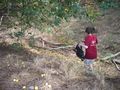
Image:2009-08-22_52-13_DSCN0378.JPG|The markers left by relet and davidc | Image:2009-08-22_52-13_DSCN0378.JPG|The markers left by relet and davidc | ||
Image:2009-08-22_52-13_DSCN0379.JPG|Just the two of us | Image:2009-08-22_52-13_DSCN0379.JPG|Just the two of us | ||
Image:2009-08-22_52-13_DSCN0382.JPG|almost there :-) | Image:2009-08-22_52-13_DSCN0382.JPG|almost there :-) | ||
| + | Image:2009-08-22_52_13_P1040630.JPG | Someone gave relet this at the main station. | ||
| + | Image:2009-08-22_52_13_2009-08-22_18.13.28.jpg | Yay for nice people! | ||
</gallery> | </gallery> | ||
== Ribbons == | == Ribbons == | ||
| − | {{Meet-up | latitude = 52 | longitude = 13 | date = 2009-08-22 | name = davidc and Trurl}} | + | {{Meet-up | latitude = 52 | longitude = 13 | date = 2009-08-22 | name = davidc, relet and Trurl}} |
{{Hash collision | latitude = 52 | longitude = 13 | date = 2009-08-22 | id = GC15NT8 | name = davidc, relet, and Trurl | distance = 262 metres}} | {{Hash collision | latitude = 52 | longitude = 13 | date = 2009-08-22 | id = GC15NT8 | name = davidc, relet, and Trurl | distance = 262 metres}} | ||
| Line 80: | Line 103: | ||
[[Category:Expeditions with photos]] | [[Category:Expeditions with photos]] | ||
[[Category:Coordinates reached]] | [[Category:Coordinates reached]] | ||
| + | {{location|DE|BB|TF}} | ||
Latest revision as of 05:19, 8 August 2019
| Sat 22 Aug 2009 in 52,13: 52.3733159, 13.3712666 geohashing.info google osm bing/os kml crox |
Location
In Birkholz (Brandenburg), just behind Berlin's southern border.
Participants
Plans
Relet will be there around noon, since he still longs to test that new electric car, and the station is only open 10-15. Parking near Nachtbucht, taking a short stroll (he is not allowed to drive the car outside the city borders), and possibly looking for a few caches later on.
Looks like a hash collision, finally!
Expedition
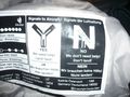
- waiting for davidc, someone leaving the town just gave me a free concert ticket. woo for nice people. -- relet 08:29, 22 August 2009 (UTC)
relet and davidc
We met at the Hauptbahnhof (main station) at 10:30 where relet rented one of the new electric Minis. The hash point was just south of Berlin, and the car wasn't allowed outside the city, so after an accidental overshooting of the city limits, we backed up and parked in Lichtenrade and walked the remaining 2km through forest and rape fields.
We visited geocache GCHAHV Balladencache on the way and passed right by another but decided to head directly to the hashpoint to keep our appointment.
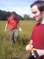
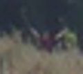
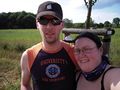
At 12:00 we arrived and had a brief argument over the exact hash point - relet was using pure GPS and davidc was also using the overhead satellite map - when Trurl turned up on his bicycle and added a third GPS to the argument. Compromising on one side of the track, the obligatory silly grin photo was taken.
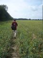
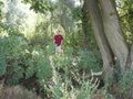
davidc then headed over to the other side of the field to the geocache GC15NT8 An den Mahlower Fishteichen. This earned us the Hash collision achievement. relet and Trurl stayed behind to take a photo. You can just about make davidc out in the red geohashing shirt across the field, thus proving line of sight for the ribbon. Further proof is shown on this point to point map. The logbook was duly signed and a red herring geocoin swiped.
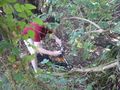
Trurl headed back home, so davidc and relet picked up another geocache, GC1TB41 Mahlower See, before ploughing into the forest with great abandon, attempting to find a direct route back to the car. Bravado gave way however to caution when a field of dense nettles forced the shorts-wearing davidc to stop. Returning to a field we found a better route, picked up GCH9NW Fuschbau and returned to the car.
Back at Hauptbahnhof, we visited GCZCQ7 Berlin's Bahnhof before parting ways. davidc remained to pick up antihistamine cream for all his bites and stings, and then did himself proud finding GCWEFD Berlin-Hauptbahnhof in broad daylight with thousands of people around, deftly timing his leap over a fence to avoid being seen by the many stationed police, and dropping down and across under a bridge.
Jerrome
Jerrome arrived at the spot somewhat late, about 1620. Using a GPS device intended for a bicycle on a motorbike prooved to be a little more difficult than previously thought. Almost lost my hat, too. Found the markers left behind by relet and davidc.
Tracklog
Hash collision confirmed line of sight: satellite proof
Photos
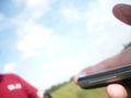
davidc in his new shirt
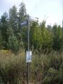
Berliner Mauerweg - the Wall was here.
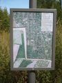
As you are informed by this map
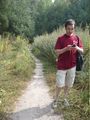
davidc leading the way

relet, following...
...wherever davidc's iPhone was pointing.
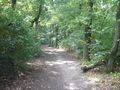
We could have taken this path instead. :P
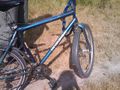
Trurl summoning the coordinates in a Mayan GPS dance
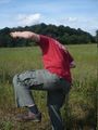
When he started this, we decided to skip on the other rituals involving blood offerings.
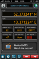
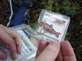
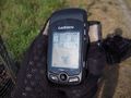
GPS coords proof
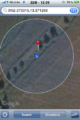
Map proof
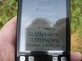
Hashdroid proof. Accuracy is making fun of us, as usual.
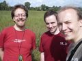
Stupid grin proof.
Random trigger art.
An invasion of geohashers!
Indeed.
davidc next to a geocache, seen from the geohash.
... with a little zoom.
What he really was trying to tell us.
Davidc near the cache
He didn't need help after all
A red herring!
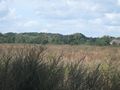
The hash, seen from the cache
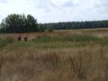
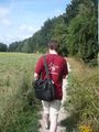
relet and david hunting for more caches

Are you sure this is the right field of nettles?

Come on, you're almost as tall as they are.
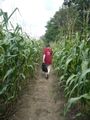
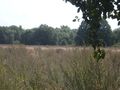
Corn fields are more walkable.
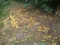
Apples!
More apples!
A geoduck of the rubbery kind
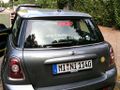
The electric Mini
Huggy Bear drives the electric car
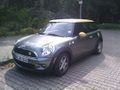
Mini also from the front
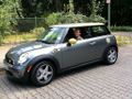
Relet being chuffed at silent running
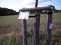
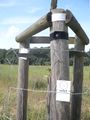
The markers left by relet and davidc
Just the two of us
almost there :-)
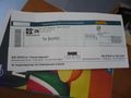
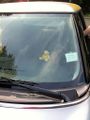
Someone gave relet this at the main station.
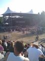
Yay for nice people!


Ribbons
davidc, relet and Trurl earned the Meet-up achievement
|
davidc, relet, and Trurl earned the Hash collision achievement
|