Difference between revisions of "2010-01-29 -38 175"
imported>Greenslime (→Plans) |
m |
||
| (25 intermediate revisions by 5 users not shown) | |||
| Line 14: | Line 14: | ||
__NOTOC__ | __NOTOC__ | ||
== Location == | == Location == | ||
| − | Lake Whakamaru, Waikato, New Zealand | + | Deforested area near Lake Whakamaru, South Waikato, New Zealand |
== Participants == | == Participants == | ||
| − | [[user:Greenslime|Greenslime]] | + | * [[user:Greenslime|Greenslime]] |
| − | + | * [[User:JimmyNZ|JimmyNZ]] | |
| − | JimmyNZ | ||
== Plans == | == Plans == | ||
| − | Spending the Auckland Anniversary long weekend doing a 3 day, 2 night tramp in the Kaimanawa Ranges, will check out this hash point on the way through. Hash appears to be in a farm paddock, just off SH30. 'Tram Road' should lead us straight there. This appears to be the first | + | Spending the Auckland Anniversary long weekend doing a 3 day, 2 night tramp in the Kaimanawa Ranges, will check out this hash point on the way through. Hash appears to be in a farm paddock, just off SH30. 'Tram Road' should lead us straight there. This appears to be the first hash for the [[South Waikato, New Zealand|South Waikato]] graticule (excellent :) and a candidate for [[East geohash achievement]] (record is currently 175.547533°E) (even more excellent :D great to be in NZ). On the same trip, we plan to check out a geocache and also place a new geocache somewhere near the Waipakihi hut in the Kaimanawas. |
== Expedition == | == Expedition == | ||
| + | As JimmyNZ and I were heading down the line for a 3 day tramping expedition and would be traveling through new territory away from Auckland's skinny isthmus, we decided to check out the location of hashes along the route (secretly thinking of multi-hash potential). We found a candidate in South Waikato, not far off a state highway that we would be taking to get to our final destination. After procuring yet another different GPS (neither of us own one but JimmyNZ has access to many) and armed with a number of A3 colour printouts of Google maps (thanks NZ taxpayer), we decided that it would be an easy hash, approximately 30 m off a small road (Tram Road) within a farm paddock. | ||
| + | |||
| + | Tram road was easy to find, and we drove past the hash about 400 m to a parking area near a bridge. Seeing no fences or houses to speak off, we strolled on into the 'paddock' finding it wasn't actually a paddock, but a deforested piece of land, probably pine. Thinking this would be easy going, we continued on in a general 'inwards' direction, hoping to double back to the hash site. The going was easy, for about 50 m, a little uneven perhaps, and then we came across blackberry - and getting thicker by the metre! At least we had the sense to ditch the jandles for the tramping boots before we started out! Cutting our losses early, we maneuvered our way back to the vehicle, and started up the road. | ||
| + | |||
| + | What lay between us and the hash site was about 30 m of thick blackberry. The next ... hour? was taken up painstakingly and painfully navigating and contorting ones body through the fiercely prickly arms of black berry bush. Myself being the one armed with gaiters was the track cutter, stomping on the bushes until they surrendered. Many times the thought of quitting entered our minds but the sweet reward of both the most Easterly hash and the Virgin hash award motivated us onwards. After a brief encounter with a paper wasps nest, we found the hash which thankfully was in a clearing, enabling us to stomp around in frustration trying to align the last decimal point of the coordinate - this required us to enter the biggest blackberry bush seen yet, which we decided against - we got close enough! After token photographs and salutations, we exited the 30 metres in about 1/12th the time it took us to enter. Victory was sweet but not without its battle scars. | ||
| + | (photos to come) | ||
== Tracklog == | == Tracklog == | ||
| − | + | SH1 to SH30, to Tram Road. | |
| + | |||
| + | == Awards == | ||
| − | |||
| − | |||
| − | |||
| − | |||
| − | |||
| − | |||
| − | |||
| + | {{East Geohash | ||
| + | | name=[[user:Greenslime|Greenslime]] | ||
| + | | latitude=-38 | ||
| + | | longitude=175 | ||
| + | | date=2010-01-29 | ||
| + | | image=2010 01 29 -38 175 Future easterly hashes await in this direction.jpg | ||
| + | }} | ||
| − | + | {{Graticule unlocked | |
| − | + | | latitude = -38 | |
| + | | longitude = 175 | ||
| + | | date = 2010-01-29 | ||
| + | | name = Greenslime | ||
| + | | image = 2010 01 29 -38 175 Beating blackberry into submission.jpg | ||
| + | }} | ||
| − | + | {{Geotrash | |
| − | + | | latitude = -38 | |
| − | + | | longitude = 175 | |
| − | - | + | | date = 2010-01-29 |
| + | | name = Greenslime | ||
| + | | image = 2010 01 29 -38 175 geotrash and rainbow.jpg | ||
| + | }} | ||
| − | + | == Photos == | |
| − | |||
| − | |||
| − | |||
| − | |||
| − | |||
| − | |||
| − | < | + | <gallery> |
| + | File:2010_01_29_-38_175_South_Waikato.jpg | South Waikato sign, these country folk are mad for their corrugated iron | ||
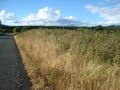
| + | File:2010_01_29_-38_175_Initial_appearances_can_be_deceiving.jpg | Initial appearances can be deceiving - the road was easy for the first few metres | ||
| + | File:2010_01_29_-38_175_Obstacle_between_us_and_the_hash.jpg | Fence of black berry between us and the hash had to be overcome first | ||
| + | File:2010_01_29_-38_175_Beating_blackberry_into_submission.jpg | Beating the black berry into submission | ||
| + | File:2010_01_29_-38_175_Kind_of_like_a_corn_field.jpg | Navigating through what was sort of like a corn field | ||
| + | File:2010_01_29_-38_175_The_hash_be_somewhere_in_that_big_bush.jpg | The hash was somewhere in that big blackberry bush | ||
| + | File:2010_01_29_-38_175_GPS_evidence.jpg | the GPS evidence | ||
| + | File:2010_01_29_-38_175_Future_easterly_hashes_await_in_this_direction.jpg | Future most easterly hashes await in this direction | ||
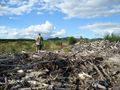
| + | File:2010_01_29_-38_175_geotrash_and_rainbow.jpg | Item of geotrash and token rainbow | ||
| + | File:2010_01_29_-38_175_more_geotrash.jpg | More geotrash | ||
| + | File:2010-01-29_-38_175_claw.jpg.jpg | Clearly, this is a claw from a [[Raptor|''velociraptor kiwi'']] | ||
| + | </gallery> | ||
| + | |||
| + | [[Category:Graticule unlocked achievement]] | ||
[[Category:Coordinates reached]] | [[Category:Coordinates reached]] | ||
| − | + | [[Category:Expeditions with photos]] | |
| − | + | [[Category:Expeditions]] | |
| − | + | {{location|NZ|WKO}} | |
| − | |||
| − | |||
| − | |||
| − | |||
| − | [[Category: | ||
| − | [[Category: | ||
| − | |||
Latest revision as of 03:10, 20 March 2024
| Fri 29 Jan 2010 in -38,175: -38.4171711, 175.9561395 geohashing.info google osm bing/os kml crox |
Location
Deforested area near Lake Whakamaru, South Waikato, New Zealand
Participants
Plans
Spending the Auckland Anniversary long weekend doing a 3 day, 2 night tramp in the Kaimanawa Ranges, will check out this hash point on the way through. Hash appears to be in a farm paddock, just off SH30. 'Tram Road' should lead us straight there. This appears to be the first hash for the South Waikato graticule (excellent :) and a candidate for East geohash achievement (record is currently 175.547533°E) (even more excellent :D great to be in NZ). On the same trip, we plan to check out a geocache and also place a new geocache somewhere near the Waipakihi hut in the Kaimanawas.
Expedition
As JimmyNZ and I were heading down the line for a 3 day tramping expedition and would be traveling through new territory away from Auckland's skinny isthmus, we decided to check out the location of hashes along the route (secretly thinking of multi-hash potential). We found a candidate in South Waikato, not far off a state highway that we would be taking to get to our final destination. After procuring yet another different GPS (neither of us own one but JimmyNZ has access to many) and armed with a number of A3 colour printouts of Google maps (thanks NZ taxpayer), we decided that it would be an easy hash, approximately 30 m off a small road (Tram Road) within a farm paddock.
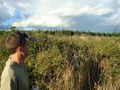
Tram road was easy to find, and we drove past the hash about 400 m to a parking area near a bridge. Seeing no fences or houses to speak off, we strolled on into the 'paddock' finding it wasn't actually a paddock, but a deforested piece of land, probably pine. Thinking this would be easy going, we continued on in a general 'inwards' direction, hoping to double back to the hash site. The going was easy, for about 50 m, a little uneven perhaps, and then we came across blackberry - and getting thicker by the metre! At least we had the sense to ditch the jandles for the tramping boots before we started out! Cutting our losses early, we maneuvered our way back to the vehicle, and started up the road.
What lay between us and the hash site was about 30 m of thick blackberry. The next ... hour? was taken up painstakingly and painfully navigating and contorting ones body through the fiercely prickly arms of black berry bush. Myself being the one armed with gaiters was the track cutter, stomping on the bushes until they surrendered. Many times the thought of quitting entered our minds but the sweet reward of both the most Easterly hash and the Virgin hash award motivated us onwards. After a brief encounter with a paper wasps nest, we found the hash which thankfully was in a clearing, enabling us to stomp around in frustration trying to align the last decimal point of the coordinate - this required us to enter the biggest blackberry bush seen yet, which we decided against - we got close enough! After token photographs and salutations, we exited the 30 metres in about 1/12th the time it took us to enter. Victory was sweet but not without its battle scars. (photos to come)
Tracklog
SH1 to SH30, to Tram Road.
Awards
Greenslime earned the East geohash achievement
|
Greenslime earned the Graticule Unlocked Achievement
|
Greenslime earned the GeoTrash Geohash Achievement
|
Photos
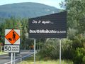
South Waikato sign, these country folk are mad for their corrugated iron
Initial appearances can be deceiving - the road was easy for the first few metres
Fence of black berry between us and the hash had to be overcome first
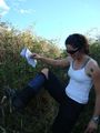
Beating the black berry into submission

Navigating through what was sort of like a corn field
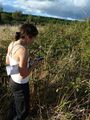
The hash was somewhere in that big blackberry bush
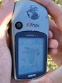
the GPS evidence
Future most easterly hashes await in this direction

Item of geotrash and token rainbow
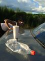
More geotrash

Clearly, this is a claw from a velociraptor kiwi


