Difference between revisions of "2010-01-31 45 -122"
imported>Jiml (Add pictures) |
imported>Jiml (Add photos, ribbons) |
||
| Line 23: | Line 23: | ||
== Expedition == | == Expedition == | ||
| − | + | This hashpoint, unlike yesterday's was pretty close to me. APR and I talked and he wasn't up to heading | |
| − | and was granted | + | out for a second day, so I went by myself. I grabbed my google maps printouts, but didn't ever look |
| + | at them, as I pretty much knew where I was going. I've had several hashpoints in that same area | ||
| + | recently. | ||
| + | |||
| + | I actually took Google Maps suggested path even though there as a good chance I wasn't going to | ||
| + | be able to figure out where I had to turn. They had a shorter path, but one that is less familiar to me. | ||
| + | However, I remembered enough about where to go that I managed to meet up with the "easy" route and | ||
| + | turn at "Roy Rogers Road". As I went, I noticed a road off to my right, and checked the GPS. | ||
| + | I was close, so I took the road and the church was right there. I parked near the main building and | ||
| + | looked at the graveyard, and then started to set out to the hashpoint. It seemed to be in a field | ||
| + | behind some buildings, so I figured I'd see about asking for permission since someone seemed to be | ||
| + | in a nearby classroom. | ||
| + | |||
| + | I gave the simple "Scavenger Hunt" description and access was granted. A little wandering in the | ||
| + | field followed, but the hashpoint was easy to get to, unlike yesterday. | ||
| + | |||
| + | A few pictures followed, and I headed back to home. I did notice that the church had a very nice | ||
| + | front door. I considered writing out my list of 95 complaints about geohashing and nailing | ||
| + | it to the door, but decided that wasn't going to work. :-) | ||
| + | |||
| + | On the way, I stopped at a nearby cafe, | ||
| + | called the "South Store", but which has changed ownership again and become the "South Store Cafe". It | ||
| + | turned out they had just closed, but I got a little something and went home. | ||
| + | |||
| + | |||
| − | |||
== Achievements == | == Achievements == | ||
| − | + | {{land geohash | |
| − | + | | latitude = 45 | |
| − | + | | longitude = l-122 | |
| + | | date = 2010-01-31 | ||
| + | | name = [[User:Jiml|Jim]] | ||
| + | }} | ||
| + | |||
| + | {{holy hash | ||
| + | | latitude = 45 | ||
| + | | longitude = l-122 | ||
| + | | date = 2010-01-31 | ||
| + | | name = [[User:Jiml|Jim]] | ||
| + | | description = Grounds of St. Paul's Lutheran Church | ||
| + | | image = 2010-01-31_45_-122-church5.jpg | ||
| + | }} | ||
Revision as of 03:30, 3 February 2010
| Sun 31 Jan 2010 in 45,-122: 45.3697908, -122.8551778 geohashing.info google osm bing/os kml crox |
Location
Sherwood, Oregon, Near St Paul's on Roy Rogers Road.
Participants
Plans
Plans weren't very firm.
I'll make the trip if I don't make an attempt on the previous day's point, and might even try this one if I do. --aperfectring 21:17, 29 January 2010 (UTC)
Jim decided to head there, however. APR wasn't up to it.
Expedition
This hashpoint, unlike yesterday's was pretty close to me. APR and I talked and he wasn't up to heading out for a second day, so I went by myself. I grabbed my google maps printouts, but didn't ever look at them, as I pretty much knew where I was going. I've had several hashpoints in that same area recently.
I actually took Google Maps suggested path even though there as a good chance I wasn't going to be able to figure out where I had to turn. They had a shorter path, but one that is less familiar to me. However, I remembered enough about where to go that I managed to meet up with the "easy" route and turn at "Roy Rogers Road". As I went, I noticed a road off to my right, and checked the GPS. I was close, so I took the road and the church was right there. I parked near the main building and looked at the graveyard, and then started to set out to the hashpoint. It seemed to be in a field behind some buildings, so I figured I'd see about asking for permission since someone seemed to be in a nearby classroom.
I gave the simple "Scavenger Hunt" description and access was granted. A little wandering in the field followed, but the hashpoint was easy to get to, unlike yesterday.
A few pictures followed, and I headed back to home. I did notice that the church had a very nice front door. I considered writing out my list of 95 complaints about geohashing and nailing it to the door, but decided that wasn't going to work. :-)
On the way, I stopped at a nearby cafe, called the "South Store", but which has changed ownership again and become the "South Store Cafe". It turned out they had just closed, but I got a little something and went home.
Achievements
Jim earned the Land geohash achievement
|
Jim earned the Holy hash achievement
|
Photos
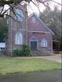
The nearby church
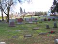
The nearby graveyard
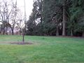
A view of the area around the hashpoint
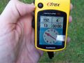
The GPS at the hashpoint


