Difference between revisions of "2010-03-21 48 11"
imported>Zb (pictures...) |
imported>FippeBot m (Location) |
||
| (14 intermediate revisions by 5 users not shown) | |||
| Line 1: | Line 1: | ||
| − | |||
| − | |||
| − | |||
| − | |||
| − | |||
| − | |||
{{meetup graticule | {{meetup graticule | ||
| lat=48 | | lat=48 | ||
| Line 15: | Line 9: | ||
== Location == | == Location == | ||
<!-- where you've surveyed the hash to be --> | <!-- where you've surveyed the hash to be --> | ||
| − | + | A few hundred meters from S-Bahn-Station Furth (S3) near a roundabout in front of Sportschule Oberhaching, just South of München. | |
== Participants == | == Participants == | ||
| − | [[User:DerFlob|DerFlob]], Johanna, [[User:The T-Man|The T-Man]], Mar, [[User:Zb|Zb]] | + | [[User:DerFlob|DerFlob]], [[User:Scherzkeks|Johanna]], [[User:The T-Man|The T-Man]], Mar, [[User:Zb|Zb]] |
== Plans == | == Plans == | ||
<!-- what were the original plans --> | <!-- what were the original plans --> | ||
| − | Should be really easy to reach. It's a few hundred meters from S-Bahn-Station Furth (S3) in front of Sportschule | + | Should be really easy to reach. It's a few hundred meters from S-Bahn-Station Furth (S3) in front of Sportschule Oberhaching. There seem to be no fences or gates, so it should be accessible even on Sunday. I guess i'll visit it. Don't know yet at what time. --[[User:DerFlob|DerFlob]] 15:15, 19 March 2010 (UTC) |
:Yeah, this one looks nice. Might go check it out some time in the (early?) afternoon before or after biking in the Perlacher Forst. --[[User:Zb|Zb]] 23:45, 19 March 2010 (UTC) | :Yeah, this one looks nice. Might go check it out some time in the (early?) afternoon before or after biking in the Perlacher Forst. --[[User:Zb|Zb]] 23:45, 19 March 2010 (UTC) | ||
::Same here, I might be there, too. Just have to figure out how, when and with whom to get there. [[User:The T-Man|The T-Man]] 13:46, 20 March 2010 (UTC) | ::Same here, I might be there, too. Just have to figure out how, when and with whom to get there. [[User:The T-Man|The T-Man]] 13:46, 20 March 2010 (UTC) | ||
| Line 29: | Line 23: | ||
:::::15:30 it is, then. We'll try to make it, too. --[[User:Zb|Zb]] 11:33, 21 March 2010 (UTC) | :::::15:30 it is, then. We'll try to make it, too. --[[User:Zb|Zb]] 11:33, 21 March 2010 (UTC) | ||
| − | == | + | == Narrative == |
<!-- how it all turned out. your narrative goes here. --> | <!-- how it all turned out. your narrative goes here. --> | ||
| − | |||
| − | == Tracklog == | + | === [[User:DerFlob|DerFlob's]], Johanna's and [[User:The T-Man|The T-Man's]] expedition === |
| + | While [[User:DerFlob|DerFlob]] went to Furth entirely by using public transport, [[User:The_T-Man|The_T-Man]] and Johanna departed one station earlier to save money on tickets and have a nice walk from Taufkirchen to Furth along the railroad tracks. DerFlob arrived at the hashpoint (which was located in front of a sports club with surprisingly large grounds and modern buildings) some two or three minutes before The_T-Man and Johanna. There, the three of them spent some time exploring the hashpoint and enjoying the warm temperatures. About fifteen minutes later, [[User:Zb|Zb]] and Mar joined them. Due to considerable luck at guessing the departure time of the next train to Munich, the trio had a flawless and quick ride back home. | ||
| + | |||
| + | === [[User:Zb|Zb's]] and Mar's expedition === | ||
| + | [[User:Zb|Zb's]] had only a bit of trouble convincing Mar to be his drag-along. The fact that the sun came out around noon and the other fact that the rain radar pictures on the internet looked like it wasn't going to rain in the afternoon were of great help in his efforts. Both left the house at around 2:22 pm and took their bikes South along the Hachinger Bach, past [[User:Zb|Zb's]] old apartment and on through Perlach, Unterhaching and into the Perlacher Forst, where they made a short stop at a smallish hill called the [http://de.wikipedia.org/wiki/Perlacher_Forst#Perlacher_Mugl Perlacher Mugl] because they wanted to take a look at the Alps. The view was excellent because of the strong Föhn winds blowing from SW. These same winds were also responsible for a slow bike ride towards the location (boo headwind!) and a very fun, fast and easy bike ride back home (yay tailwind!). | ||
| + | |||
| + | After enjoying the view, they went further South through the forest towards the coordinates. Only some small patches of snow were left along the way, which was great. | ||
| + | |||
| + | === The Meet-Up === | ||
| + | |||
| + | When [[User:Zb|Zb]] and Mar came out of the forest, the coordinates were found quickly. [[User:DerFlob|DerFlob]], Johanna and [[User:The T-Man|The T-Man]] were already there and had figured out the exact location next to the roundabout that was visible on the satellite images and maps. Pictures were taken and everyone headed home again. [[User:DerFlob|DerFlob]], Johanna and [[User:The T-Man|The T-Man]] were at the train station just in time for the next train back to München and [[User:Zb|Zb]] and Mar enjoyed great tailwinds while riding their bikes back. | ||
| + | |||
| + | <!-- == Tracklog == --> | ||
<!-- if your GPS device keeps a log, you may post a link here --> | <!-- if your GPS device keeps a log, you may post a link here --> | ||
| Line 40: | Line 45: | ||
Image:2009-##-## ## ## Alpha.jpg | Witty Comment | Image:2009-##-## ## ## Alpha.jpg | Witty Comment | ||
--> | --> | ||
| + | === Enjoying the view of the Alps on the way to the coordinates === | ||
| + | <gallery perrow="4"> | ||
| + | Image:2010-03-21 48 11 zb Furth 0001.jpg | Some snow on the North edge of the Perlacher Mugl. Hopefully no more snow for this season... | ||
| + | Image:2010-03-21 48 11 zb Furth 0005.jpg | Except, maybe, in the mountains. | ||
| + | Image:2010-03-21 48 11 zb Furth 0004.jpg | The forest, some tall buildings in Taufkirchen and the Alps. The tallest one is the Wendelstein. | ||
| + | </gallery> | ||
| + | |||
| + | === The Meet-Up === | ||
<gallery perrow="4"> | <gallery perrow="4"> | ||
Image:2010-03-21 48 11 zb Furth 0009.jpg | Fancy fire alarm display. The red bar between buildings A and C is very close to where the coordinates would be... | Image:2010-03-21 48 11 zb Furth 0009.jpg | Fancy fire alarm display. The red bar between buildings A and C is very close to where the coordinates would be... | ||
| + | Image:2010-03-21 48 11 Flob 02.jpg | Frontview of the main building of the Sportschule Oberhaching, from the roundabout, next to the geohash. | ||
Image:2010-03-21 48 11 zb Furth 0008.jpg | [[User:Zb|Zb]], [[User:DerFlob|DerFlob]], [[User:The T-Man|The T-Man]] are at the coordinates. Thanks to Mar for taking the picture. | Image:2010-03-21 48 11 zb Furth 0008.jpg | [[User:Zb|Zb]], [[User:DerFlob|DerFlob]], [[User:The T-Man|The T-Man]] are at the coordinates. Thanks to Mar for taking the picture. | ||
| + | Image:2010-03-21 48 11 zb Furth 0011.jpg | [[User:DerFlob|DerFlob]] and [[User:The T-Man|The T-Man]] in front of the roundabout that's clearly visible on the satellite images for this geohash. | ||
| + | Image:2010-03-21-TMan-01.jpeg | Spring clearly has taken over the hashpoint. | ||
| + | Image:2010-03-21 48 11 Flob 01.jpg | View from the geohash to the roundabout. | ||
| + | </gallery> | ||
| + | === Back to München === | ||
| + | <gallery perrow="4"> | ||
| + | Image:2010-03-21 48 11 zb Furth 0012.jpg | A München-bound train back from Furth ... | ||
| + | Image:2010-03-21 48 11 zb Furth 0013.jpg | ... with [[User:DerFlob|DerFlob]], Johanna and [[User:The T-Man|The T-Man]] on board. | ||
| + | Image:2010-03-21-TMan-02.jpeg | Another train to München that [[User:The_T-Man|The_T-Man]] took a photo of on his way to the hashpoint. | ||
| + | Image:2010-03-21 48 11 zb Furth 0014.jpg | [[Revisited|Revisiting]] the bridge that [[User:Zb|Zb]] also crossed on the way to [[2009-12-30 47 11]]. | ||
| + | Image:2010-03-21 48 11 zb Furth 0015.jpg | Looking the other way. Exit Neubiberg along Autobahn A8, München's Olympic Tower is in the background. | ||
| + | Image:2010-03-21 48 11 zb Furth 0016.jpg | Drag-along Mar. | ||
| + | Image:2010-03-21 48 11 zb Furth 0018.jpg | [[User:Zb|Zb's]] and Mar's bikes. Great how increased contrast in a picture makes a 13-year-old bike with an estimated 60000 km on it look like new. Also, note the new fork that I had to put in instead of the original blue one after [[2010-02-21_48_11#The_Aftermath|a recent geohash]]. | ||
| + | Image:2010-03-21 48 11 zb Furth 0019.jpg | In the background, you can see the ''Hypo-Hochhaus'', also featured in a [[2010-03-17 48 11|recent geohash]]. | ||
</gallery> | </gallery> | ||
| − | |||
| − | |||
| − | |||
| − | |||
| − | |||
| − | |||
| − | |||
| − | |||
[[Category:Expeditions]] | [[Category:Expeditions]] | ||
| − | |||
[[Category:Expeditions with photos]] | [[Category:Expeditions with photos]] | ||
| − | |||
[[Category:Expedition without GPS]] | [[Category:Expedition without GPS]] | ||
| − | |||
| − | |||
| − | |||
[[Category:Coordinates reached]] | [[Category:Coordinates reached]] | ||
| − | + | {{location|DE|BY|M}} | |
| − | |||
| − | |||
| − | |||
| − | |||
| − | |||
| − | |||
| − | |||
| − | |||
| − | |||
Latest revision as of 01:17, 9 August 2019
| Sun 21 Mar 2010 in 48,11: 48.0357446, 11.5903695 geohashing.info google osm bing/os kml crox |
Location
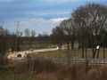
A few hundred meters from S-Bahn-Station Furth (S3) near a roundabout in front of Sportschule Oberhaching, just South of München.
Participants
DerFlob, Johanna, The T-Man, Mar, Zb
Plans
Should be really easy to reach. It's a few hundred meters from S-Bahn-Station Furth (S3) in front of Sportschule Oberhaching. There seem to be no fences or gates, so it should be accessible even on Sunday. I guess i'll visit it. Don't know yet at what time. --DerFlob 15:15, 19 March 2010 (UTC)
- Yeah, this one looks nice. Might go check it out some time in the (early?) afternoon before or after biking in the Perlacher Forst. --Zb 23:45, 19 March 2010 (UTC)
- Same here, I might be there, too. Just have to figure out how, when and with whom to get there. The T-Man 13:46, 20 March 2010 (UTC)
- Well, the weather report says it's raining tomorrow, but afaik not that much (hopefully). So I'll check it out at about 15:30, if you guys have time there? --DerFlob 20:29, 20 March 2010 (UTC)
- Same here, I might be there, too. Just have to figure out how, when and with whom to get there. The T-Man 13:46, 20 March 2010 (UTC)
Narrative
DerFlob's, Johanna's and The T-Man's expedition
While DerFlob went to Furth entirely by using public transport, The_T-Man and Johanna departed one station earlier to save money on tickets and have a nice walk from Taufkirchen to Furth along the railroad tracks. DerFlob arrived at the hashpoint (which was located in front of a sports club with surprisingly large grounds and modern buildings) some two or three minutes before The_T-Man and Johanna. There, the three of them spent some time exploring the hashpoint and enjoying the warm temperatures. About fifteen minutes later, Zb and Mar joined them. Due to considerable luck at guessing the departure time of the next train to Munich, the trio had a flawless and quick ride back home.
Zb's and Mar's expedition
Zb's had only a bit of trouble convincing Mar to be his drag-along. The fact that the sun came out around noon and the other fact that the rain radar pictures on the internet looked like it wasn't going to rain in the afternoon were of great help in his efforts. Both left the house at around 2:22 pm and took their bikes South along the Hachinger Bach, past Zb's old apartment and on through Perlach, Unterhaching and into the Perlacher Forst, where they made a short stop at a smallish hill called the Perlacher Mugl because they wanted to take a look at the Alps. The view was excellent because of the strong Föhn winds blowing from SW. These same winds were also responsible for a slow bike ride towards the location (boo headwind!) and a very fun, fast and easy bike ride back home (yay tailwind!).
After enjoying the view, they went further South through the forest towards the coordinates. Only some small patches of snow were left along the way, which was great.
The Meet-Up
When Zb and Mar came out of the forest, the coordinates were found quickly. DerFlob, Johanna and The T-Man were already there and had figured out the exact location next to the roundabout that was visible on the satellite images and maps. Pictures were taken and everyone headed home again. DerFlob, Johanna and The T-Man were at the train station just in time for the next train back to München and Zb and Mar enjoyed great tailwinds while riding their bikes back.
Photos
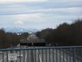
Enjoying the view of the Alps on the way to the coordinates
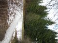
Some snow on the North edge of the Perlacher Mugl. Hopefully no more snow for this season...
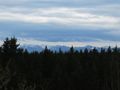
Except, maybe, in the mountains.
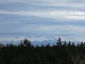
The forest, some tall buildings in Taufkirchen and the Alps. The tallest one is the Wendelstein.


The Meet-Up
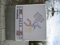
Fancy fire alarm display. The red bar between buildings A and C is very close to where the coordinates would be...
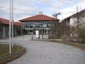
Frontview of the main building of the Sportschule Oberhaching, from the roundabout, next to the geohash.
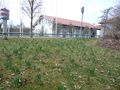
Spring clearly has taken over the hashpoint.
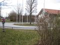
View from the geohash to the roundabout.


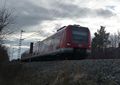
Back to München
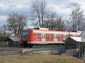
A München-bound train back from Furth ...
Another train to München that The_T-Man took a photo of on his way to the hashpoint.
Revisiting the bridge that Zb also crossed on the way to 2009-12-30 47 11.
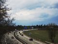
Looking the other way. Exit Neubiberg along Autobahn A8, München's Olympic Tower is in the background.
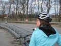
Drag-along Mar.

Zb's and Mar's bikes. Great how increased contrast in a picture makes a 13-year-old bike with an estimated 60000 km on it look like new. Also, note the new fork that I had to put in instead of the original blue one after a recent geohash.
In the background, you can see the Hypo-Hochhaus, also featured in a recent geohash.


