Difference between revisions of "2010-03-27 48 11"
imported>DerFlob (pictures added, more to come) |
m (Location correction) |
||
| (10 intermediate revisions by 4 users not shown) | |||
| Line 15: | Line 15: | ||
== Location == | == Location == | ||
<!-- where you've surveyed the hash to be --> | <!-- where you've surveyed the hash to be --> | ||
| + | The hashpoint was located on a meadow near Geisenbrunn, about 10 or 20 metres away from the S8 railroad tracks. | ||
== Participants == | == Participants == | ||
| Line 22: | Line 23: | ||
== Expedition == | == Expedition == | ||
<!-- how it all turned out. your narrative goes here. --> | <!-- how it all turned out. your narrative goes here. --> | ||
| + | [[User:DerFlob|DerFlob]] and [[User:The_T-Man|The_T-Man]] met at The_T-Man's place at about 14 o'clock and started an expedition that was planned to be a bicycle ride of a bit more than 50km. They proceeded towards downtown München, where they stopped to take some pictures and then pushed their bikes along the shops and malls of Kaufingerstraße, which was - typically for this time of the week - very crowded. When they arrived at Hauptbahnhof, they were glad to be able to continue cycling again. Throughout most of the rest of their way towards the hashpoint they more or less followed the railroad tracks through the suburban areas of Pasing and Neuaubing and passed by the satellite township of Germering/Unterpfaffenhofen, where they unsuccessfully searched for some sort of fast food restaurant. Having been slowed down and exhausted by rather heavy headwind, they were quite glad when they finally reached the haspoint, which turned out to be on a meadow next to the S-Bahn tracks opposite to a pet obedience school and some 500 metres away from a golf course with driving range. Due to their low stamina that was partly a result of the long winter and partly - well, their normal condition, they decided to take a suburban train back home, which departed from the nearby village of Geisenbrunn just in time. | ||
== Tracklog == | == Tracklog == | ||
| − | + | [http://www.mediafire.com/?m2myk2ymz2t Tracklog on MediaFire by DerFlob] | |
== Photos == | == Photos == | ||
| Line 30: | Line 32: | ||
Image:2009-##-## ## ## Alpha.jpg | Witty Comment | Image:2009-##-## ## ## Alpha.jpg | Witty Comment | ||
--> | --> | ||
| − | <gallery perrow=" | + | <gallery perrow="5"> |
| + | Image:2010-03-27 48 11 Tman01.JPG | A view of the famous Frauenkirche, Mariensäule and town hall of München | ||
| + | Image:2010-03-27 48 11 Tman02.JPG | The crowd at Kaufingerstraße should be avoided by cyclists on saturdays | ||
Image:2010-03-27_48_11_Flob_01.jpg | Successfully reached | Image:2010-03-27_48_11_Flob_01.jpg | Successfully reached | ||
Image:2010-03-27_48_11_Flob_03.jpg | [[User:The T-Man|The T-Man]] and his bike | Image:2010-03-27_48_11_Flob_03.jpg | [[User:The T-Man|The T-Man]] and his bike | ||
| + | Image:2010-03-27 48 11 Tman03.JPG | [[User:DerFlob|DerFlob]] and the bikes | ||
Image:2010-03-27_48_11_Flob_05.jpg | A S-Bahn driving past the hashpoint - pretty much the only interesting thing out there | Image:2010-03-27_48_11_Flob_05.jpg | A S-Bahn driving past the hashpoint - pretty much the only interesting thing out there | ||
| + | Image:2010-03-27 48 11 Tman05.JPG | The village centre of Geisenbrunn | ||
| + | Image:2010-03-27 48 11 Tman04.JPG | The two geohashers attract the attention of local wildlife | ||
</gallery> | </gallery> | ||
| − | |||
| − | == Achievement == | + | == Achievement ribbons == |
{{Bicycle geohash | {{Bicycle geohash | ||
| latitude = 48 | | latitude = 48 | ||
| Line 43: | Line 49: | ||
| date = 2010-03-27 | | date = 2010-03-27 | ||
| name = [[User:The T-Man|The T-Man]] and [[User:DerFlob|DerFlob]] | | name = [[User:The T-Man|The T-Man]] and [[User:DerFlob|DerFlob]] | ||
| − | | distance = 25 | + | | distance = 25 km |
}} | }} | ||
| − | |||
| − | |||
| − | |||
[[Category:Expeditions]] | [[Category:Expeditions]] | ||
[[Category:Expeditions with photos]] | [[Category:Expeditions with photos]] | ||
[[Category:Coordinates reached]] | [[Category:Coordinates reached]] | ||
| + | {{location|DE|BY|STA}} | ||
Latest revision as of 20:01, 16 May 2020
| Sat 27 Mar 2010 in 48,11: 48.1100009, 11.3358874 geohashing.info google osm bing/os kml crox |
Location
The hashpoint was located on a meadow near Geisenbrunn, about 10 or 20 metres away from the S8 railroad tracks.
Participants
Expedition
DerFlob and The_T-Man met at The_T-Man's place at about 14 o'clock and started an expedition that was planned to be a bicycle ride of a bit more than 50km. They proceeded towards downtown München, where they stopped to take some pictures and then pushed their bikes along the shops and malls of Kaufingerstraße, which was - typically for this time of the week - very crowded. When they arrived at Hauptbahnhof, they were glad to be able to continue cycling again. Throughout most of the rest of their way towards the hashpoint they more or less followed the railroad tracks through the suburban areas of Pasing and Neuaubing and passed by the satellite township of Germering/Unterpfaffenhofen, where they unsuccessfully searched for some sort of fast food restaurant. Having been slowed down and exhausted by rather heavy headwind, they were quite glad when they finally reached the haspoint, which turned out to be on a meadow next to the S-Bahn tracks opposite to a pet obedience school and some 500 metres away from a golf course with driving range. Due to their low stamina that was partly a result of the long winter and partly - well, their normal condition, they decided to take a suburban train back home, which departed from the nearby village of Geisenbrunn just in time.
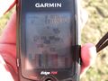
Tracklog
Tracklog on MediaFire by DerFlob
Photos
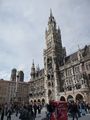
A view of the famous Frauenkirche, Mariensäule and town hall of München
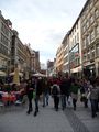
The crowd at Kaufingerstraße should be avoided by cyclists on saturdays
Successfully reached
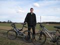
The T-Man and his bike
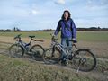
DerFlob and the bikes
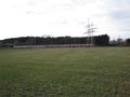
A S-Bahn driving past the hashpoint - pretty much the only interesting thing out there
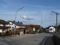
The village centre of Geisenbrunn
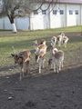
The two geohashers attract the attention of local wildlife


Achievement ribbons
The T-Man and DerFlob earned the Bicycle geohash achievement
|