Difference between revisions of "2010-04-20 45 -122"
imported>Aperfectring (→Photos) |
imported>Jiml (Adding Photos, awards, and text) |
||
| Line 18: | Line 18: | ||
== Participants == | == Participants == | ||
| − | *[[User:Aperfectring|APR]] | + | *[[User:Aperfectring|APR]] |
| − | *[[User:Jiml|Jim]] | + | *[[User:Jiml|Jim]] |
| − | *[[User:starbird|starbird]] | + | *[[User:starbird|starbird]] |
== Plans == | == Plans == | ||
| Line 28: | Line 28: | ||
Starbird: leave us a marker if you end up going! I can't get out of work until after 5PM. --[[User:Aperfectring|aperfectring]] 21:11, 20 April 2010 (UTC) | Starbird: leave us a marker if you end up going! I can't get out of work until after 5PM. --[[User:Aperfectring|aperfectring]] 21:11, 20 April 2010 (UTC) | ||
| − | Jim didn't bring boots or the camera to work, so | + | Jim didn't bring boots or the camera to work, so did need to swing by home. The GPS is here, but |
no spare batteries. His brain decided that "the hashpoint is way too far north for me to go to" | no spare batteries. His brain decided that "the hashpoint is way too far north for me to go to" | ||
when packing this morning. [[User:Jiml|Jiml]] 21:42, 20 April 2010 (UTC) | when packing this morning. [[User:Jiml|Jiml]] 21:42, 20 April 2010 (UTC) | ||
== Expedition == | == Expedition == | ||
| − | + | ||
| + | === Starbird === | ||
| + | It appears that Starbird came by, and left a note for Jim and APR. In the note, he indicated that | ||
| + | he'd been repelled by the blackberries, and was | ||
| + | |||
=== Jim and Aperfectring === | === Jim and Aperfectring === | ||
| − | Jim started the expedition by picking up Aperfectring, and then proceeding home to pick up a camera and boots. We then proceeded to drive up to Sauvie island, and hiked along the path to the hashpoint. At the hashpoint, we discovered a marker left by Starbird, and copious amounts of blackberry brambles. We decided that we could at least make part of the way in, if not all the way. Jim bravely led the way, obtaining a grievous injury in the process. At about 30ft from the hashpoint, on the edge of the uncertainty circle, and when they were confronted with ~6ft (2m) brambles for the remaining distance, they decided to call it good enough, turn tail, and run. | + | |
| + | |||
| + | Jim started the expedition by picking up Aperfectring, and then proceeding home to pick up a camera and boots. | ||
| + | |||
| + | *Picking up supplies from the fort on our way to the Columbia River! -- [[User:Aperfectring|aperfectring]] [http://www.openstreetmap.org/?lat=45.394075&lon=-122.86004&zoom=16&layers=B000FTF @45.3941,-122.8600] 01:02, 21 April 2010 (UTC) | ||
| + | |||
| + | We then proceeded to drive up to Sauvie island, and hiked along the path to the hashpoint. At the hashpoint, we discovered a marker left by Starbird, and copious amounts of blackberry brambles. We decided that we could at least make part of the way in, if not all the way. Jim bravely led the way, obtaining a grievous injury in the process. At about 30ft from the hashpoint, on the edge of the uncertainty circle, and when they were confronted with ~6ft (2m) brambles for the remaining distance, they decided to call it good enough, turn tail, and run. | ||
*Picking up supplies from the fort on our way to the Columbia River! -- [[User:Aperfectring|aperfectring]] [http://www.openstreetmap.org/?lat=45.394075&lon=-122.86004&zoom=16&layers=B000FTF @45.3941,-122.8600] 01:02, 21 April 2010 (UTC) | *Picking up supplies from the fort on our way to the Columbia River! -- [[User:Aperfectring|aperfectring]] [http://www.openstreetmap.org/?lat=45.394075&lon=-122.86004&zoom=16&layers=B000FTF @45.3941,-122.8600] 01:02, 21 April 2010 (UTC) | ||
| Line 41: | Line 51: | ||
*After a tenuously reached hashpoint, our intrepid geohashers head for tasty foods. -- [[User:Aperfectring|aperfectring]] [http://www.openstreetmap.org/?lat=45.646080516666665&lon=-122.84159416666667&zoom=16&layers=B000FTF @45.6461,-122.8416] 02:35, 21 April 2010 (UTC) | *After a tenuously reached hashpoint, our intrepid geohashers head for tasty foods. -- [[User:Aperfectring|aperfectring]] [http://www.openstreetmap.org/?lat=45.646080516666665&lon=-122.84159416666667&zoom=16&layers=B000FTF @45.6461,-122.8416] 02:35, 21 April 2010 (UTC) | ||
| + | <!-- Probably no tracklog | ||
== Tracklog == | == Tracklog == | ||
<!-- if your GPS device keeps a log, you may post a link here --> | <!-- if your GPS device keeps a log, you may post a link here --> | ||
| Line 48: | Line 59: | ||
Image:2010-04-20_45_-122_19-14-46-776.jpg | Ouchy thorns which gave jim a raptor attack. [http://www.openstreetmap.org/?lat=45.66166711666666&lon=-122.84358415&zoom=16&layers=B000FTF @45.6617,-122.8436] | Image:2010-04-20_45_-122_19-14-46-776.jpg | Ouchy thorns which gave jim a raptor attack. [http://www.openstreetmap.org/?lat=45.66166711666666&lon=-122.84358415&zoom=16&layers=B000FTF @45.6617,-122.8436] | ||
Image:2010-04-20_45_-122_apr01.JPG | The Willamette River, from Sauvie Island. | Image:2010-04-20_45_-122_apr01.JPG | The Willamette River, from Sauvie Island. | ||
| + | Image:2010-04-20_45_-122-apr.jpg | APR with Starbird's marker | ||
Image:2010-04-20_45_-122_apr02.JPG | Jim near Starbird's marker. | Image:2010-04-20_45_-122_apr02.JPG | Jim near Starbird's marker. | ||
| + | Image:2010-04-20_45_-122-starbird.jpg | Starbird's note | ||
Image:2010-04-20_45_-122_apr03.JPG | Looking in towards the hashpoint, its behind the brambles. | Image:2010-04-20_45_-122_apr03.JPG | Looking in towards the hashpoint, its behind the brambles. | ||
Image:2010-04-20_45_-122_apr05.JPG | Jim's raptor attack. | Image:2010-04-20_45_-122_apr05.JPG | Jim's raptor attack. | ||
Image:2010-04-20_45_-122_apr06.JPG | The brambles in the way. This photo was not taken downward. | Image:2010-04-20_45_-122_apr06.JPG | The brambles in the way. This photo was not taken downward. | ||
Image:2010-04-20_45_-122_apr07.JPG | Proofs. | Image:2010-04-20_45_-122_apr07.JPG | Proofs. | ||
| + | Image:2010-04-20_45_-122-pond.jpg | The pond near the hashpoint | ||
Image:2010-04-20_45_-122_apr08.JPG | The lake on Sauvie Island, which is at the confluence of the Willamette and Columbia Rivers | Image:2010-04-20_45_-122_apr08.JPG | The lake on Sauvie Island, which is at the confluence of the Willamette and Columbia Rivers | ||
Image:2010-04-20_45_-122_apr09.JPG | The way to the hashpoint from the parking lot. | Image:2010-04-20_45_-122_apr09.JPG | The way to the hashpoint from the parking lot. | ||
| + | |||
| + | |||
</gallery> | </gallery> | ||
Revision as of 16:50, 21 April 2010
| Tue 20 Apr 2010 in 45,-122: 45.6616994, -122.8442336 geohashing.info google osm bing/os kml crox |
Location
Along side a walking/biking path on Sauvie Island.
Participants
Plans
Gather together GPS units, cameras, peoples, vehicles, boots, drive to the parking lot, and (hopefully) reach the hashpoint.
Starbird: leave us a marker if you end up going! I can't get out of work until after 5PM. --aperfectring 21:11, 20 April 2010 (UTC)
Jim didn't bring boots or the camera to work, so did need to swing by home. The GPS is here, but no spare batteries. His brain decided that "the hashpoint is way too far north for me to go to" when packing this morning. Jiml 21:42, 20 April 2010 (UTC)
Expedition
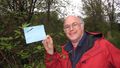
Starbird
It appears that Starbird came by, and left a note for Jim and APR. In the note, he indicated that he'd been repelled by the blackberries, and was
Jim and Aperfectring
Jim started the expedition by picking up Aperfectring, and then proceeding home to pick up a camera and boots.
- Picking up supplies from the fort on our way to the Columbia River! -- aperfectring @45.3941,-122.8600 01:02, 21 April 2010 (UTC)
We then proceeded to drive up to Sauvie island, and hiked along the path to the hashpoint. At the hashpoint, we discovered a marker left by Starbird, and copious amounts of blackberry brambles. We decided that we could at least make part of the way in, if not all the way. Jim bravely led the way, obtaining a grievous injury in the process. At about 30ft from the hashpoint, on the edge of the uncertainty circle, and when they were confronted with ~6ft (2m) brambles for the remaining distance, they decided to call it good enough, turn tail, and run.
- Picking up supplies from the fort on our way to the Columbia River! -- aperfectring @45.3941,-122.8600 01:02, 21 April 2010 (UTC)
- After a tenuously reached hashpoint, our intrepid geohashers head for tasty foods. -- aperfectring @45.6461,-122.8416 02:35, 21 April 2010 (UTC)
Photos
Ouchy thorns which gave jim a raptor attack. @45.6617,-122.8436
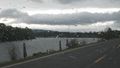
The Willamette River, from Sauvie Island.
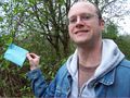
APR with Starbird's marker
Jim near Starbird's marker.
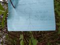
Starbird's note
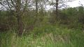
Looking in towards the hashpoint, its behind the brambles.
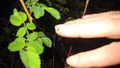
Jim's raptor attack.
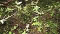
The brambles in the way. This photo was not taken downward.
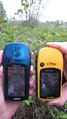
Proofs.
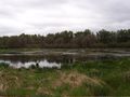
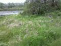
The pond near the hashpoint
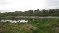
The lake on Sauvie Island, which is at the confluence of the Willamette and Columbia Rivers
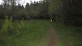
The way to the hashpoint from the parking lot.


