Difference between revisions of "2010-05-22 49 -123"
imported>Robyn (Some more recollections) |
imported>Robyn (The write up is not complete, but I'm done for today.) |
||
| Line 1: | Line 1: | ||
| − | This is the Vancouver graticule's official [[Mouseover Day]] celebration for 2010. | + | This is the Vancouver graticule's official [[Mouseover Day]] celebration for 2010. Mouseover Day is supposed to be for people who are unable, due to work or other commitments, to geohash on May 21st, but the Vancouver graticule stayed up past midnight celebrating Geohashing Day and ''then'' went to this one. Why would we miss a Saturday of geohashing? |
[[Image:2010-05-22 49 -123.withflag.jpg|Welcome to Mouseover Day Basecamp|thumb|left]] | [[Image:2010-05-22 49 -123.withflag.jpg|Welcome to Mouseover Day Basecamp|thumb|left]] | ||
| Line 9: | Line 9: | ||
}} | }} | ||
| − | |||
__NOTOC__ | __NOTOC__ | ||
== Location == | == Location == | ||
| − | |||
Some 600m off shore in Sechelt. Google maps shows a possible beach access at the closest land approach. | Some 600m off shore in Sechelt. Google maps shows a possible beach access at the closest land approach. | ||
However, the closest land approach (Shorncliffe Ave. and Boulevard) is a trail closed to cars. There's a big public parking lot a few blocks away, at Ocean and Sunshine Coast Hwy. Gear dropoff at Ocean and Boulevard then parking may be the best option. The beach at Ocean is an actual beach in street view, where over at Shorncliffe it looks more rocky and may or may not be beach-like. | However, the closest land approach (Shorncliffe Ave. and Boulevard) is a trail closed to cars. There's a big public parking lot a few blocks away, at Ocean and Sunshine Coast Hwy. Gear dropoff at Ocean and Boulevard then parking may be the best option. The beach at Ocean is an actual beach in street view, where over at Shorncliffe it looks more rocky and may or may not be beach-like. | ||
| Line 86: | Line 84: | ||
The point of a basecamp is to form the base for further expedition, and our true destination was 650 metres south into the sea. It was a trivial distance compared to some kayak adventures we have had, and given our strength of numbers and experience we were fully prepared to reach it. | The point of a basecamp is to form the base for further expedition, and our true destination was 650 metres south into the sea. It was a trivial distance compared to some kayak adventures we have had, and given our strength of numbers and experience we were fully prepared to reach it. | ||
====Boat#1: thepiguy==== | ====Boat#1: thepiguy==== | ||
| − | As pi had been there about two hours longer than anyone else, he was eager to make an attempt and launched his dingy before all the kayaks were unloaded and set up. The wind looked seemed to be blowing almost directly towards the beach from the geohash, | + | As pi had been there about two hours longer than anyone else, he was eager to make an attempt and launched his dingy before all the kayaks were unloaded and set up. The wind looked seemed to be blowing almost directly towards the beach from the geohash, and we watched from the beach with grave concern as he launched into the waves and rapidly drifted downwind, struggling with paddle configuration and really stupid oarlocks. "How far out is he?" asked Juventas, for whom this was the first waterhash, after about twenty minutes. |
| + | |||
| + | "About 30 metres," someone explained. | ||
| + | |||
| + | "So that means he has to go twenty times that far?" | ||
| + | |||
| + | This report will wait, as did the geohashers on the beach, for the results of pi's expedition by his own efforts. | ||
[[Image:2010-05-22 49 -123.concern.jpg|Geohashers watching with grave concern as pi struggles with waves and wind|thumb]] | [[Image:2010-05-22 49 -123.concern.jpg|Geohashers watching with grave concern as pi struggles with waves and wind|thumb]] | ||
| − | ====Flotilla #2: Robyn | + | ====Flotilla #2: Robyn, Rhonda, Xore and Juventas==== |
| + | Next the kayakers prepared their craft for an assault on the coordinates. Robyn laid out her boat on the flat part of the rocks and inflated the three sections tubes. Rhonda sent Xore back to the car for something that was missing, then began to assemble her boat. Xore declared, "I'm here and my boat is here. Anyone who wants to borrow my boat can go ahead." Juventas took him up on the offer and began to follow the inflatable kayak assembly instructions. | ||
| + | |||
| + | Robyn began to load snacks into her kayak and then paused. "I hear hissing." Hissing and inflatable kayaks, the group agreed, were bad. Either there is a snake in the boat or it is leaking. Either way, you should not put your legs inside. After some disassembly Robyn identified the source of the hissing as a small crack next to one of the seams in a side tube. | ||
| + | |||
| + | Rhonda nodded knowledgeably. "They're hard to patch there. That's the same place I had one." Rhonda explained the proper technique of cutting down the ridge on the seam, then putting patches on each side of it, and then apply a final bridging patch, in order to cover the hole without getting an air gap. Robyn hadn't brought a patch kit, so Rhonda sent Xore to the car for hers. | ||
| + | |||
| + | About the time Robyn was finishing her first patch, ''Rhonda'' heard hissing. At the same seam. Rhonda's patching technique had held up for a number of expeditions, but chose the most ironic time to give out. Not the worst time. That might be 650 metres out to sea. Rhonda started patching hers. After twenty minutes or so, Robyn tested her patch work by inflating the tube. There was ''less'' hissing, but still hissing. Rhonda made two patching attempts, both of which ended in hissing. | ||
| + | |||
| + | The boat that Juventas inflated did not hiss, but his enthusiasm may have subsided slightly after that. | ||
| + | |||
====Boat#5: Challenger==== | ====Boat#5: Challenger==== | ||
===Picnicking & General Revelry=== | ===Picnicking & General Revelry=== | ||
| − | , | + | Aside from the entertainment afforded by multiple people failing to reach the geohash by boat, basecamp festivities included samosas, cake, pie, Nibs, German gummi bears, hot chocolate, s'mores, and a selection of large, small, white and multicoloured marshmallows. The pie was provided by thepieguy as a bribe in exchange for a ride home from Geohashing Day, because he wasn't sure if the buses were still running. We also posed for a recreation of a [[http://www.iwojima.com/raising/raisingc.htm famous photograph]]. We didn't have enough people to do ''The Last Supper''. |
| + | |||
| + | It was too windy for board games, so we saved them for the ferry home. | ||
| + | |||
<gallery> | <gallery> | ||
| − | Image:2010-05-22 49 -123.thelook.jpg|"Xore, could you please go to the car and get ..." | + | Image:2010-05-22 49 -123.thelook.jpg|"Xore, could you please go to the car and get ..." |
| − | Image:2010-05-22 49 -123.monopod.jpg|Pi improvised a camera monopod for a group photo showing everyone | + | Image:2010-05-22 49 -123.monopod.jpg|Pi improvised a camera monopod for a group photo showing everyone |
| − | Image:2010-05-22 49 -123.campstove.jpg|Yangman made everyone hot chocolate | + | Image:2010-05-22 49 -123.campstove.jpg|Yangman made everyone hot chocolate |
</gallery> | </gallery> | ||
| Line 125: | Line 142: | ||
http://www.everytrail.com/view_trip.php?trip_id=631206 | http://www.everytrail.com/view_trip.php?trip_id=631206 | ||
| − | |||
| − | |||
| − | |||
| − | |||
| − | |||
| − | |||
| − | |||
| − | |||
== Achievements == | == Achievements == | ||
Revision as of 00:59, 24 May 2010
This is the Vancouver graticule's official Mouseover Day celebration for 2010. Mouseover Day is supposed to be for people who are unable, due to work or other commitments, to geohash on May 21st, but the Vancouver graticule stayed up past midnight celebrating Geohashing Day and then went to this one. Why would we miss a Saturday of geohashing?

| Sat 22 May 2010 in 49,-123: 49.4635260, -123.7646015 geohashing.info google osm bing/os kml crox |
Location
Some 600m off shore in Sechelt. Google maps shows a possible beach access at the closest land approach. However, the closest land approach (Shorncliffe Ave. and Boulevard) is a trail closed to cars. There's a big public parking lot a few blocks away, at Ocean and Sunshine Coast Hwy. Gear dropoff at Ocean and Boulevard then parking may be the best option. The beach at Ocean is an actual beach in street view, where over at Shorncliffe it looks more rocky and may or may not be beach-like.
Good place for a beach celebration, though. Picnic tables and everything.
Participants
- Arbron - with a friend, but no boat
- Elbie - boatlessly
- Juventas - with the Challenger raft
- Robyn - with Amazingly Enough and T-Rex
- Rhonda - with her kayak and Sophie
- user:thepiguy - with a rubber raft and d/dRex
- Wade - with his infamous GPS
- Xore - with his kayak, but no intention of using it
- yangman - with a campstove and hot chocolate
- Ben - friend of Arbron
- thepiguy's parents, but briefly and before the others arrived
- four nameless strangers who accepted offers of free cake and pie
That makes ten official participants and six unofficial ones, not including boats, hashcots and other inanimate objects with personalities.
Plans
The original plan (preserved on the talk page) was very simple: meet at the 9:20 Ferry to Gibsons, drive to Sechelt, take a motley collection of watercraft out to the point, then party on the beach. We knew in advance that we would be out a bit late on the Geohashing Day expedition so we went for the 9:20 ferry instead of the first one at 7:20.
You know what they say about the best laid plans of mice. It apparently applies to Mouseover Day as well.
Expedition
Catching A Ferry
In order to ensure a robust hash, participants were distributed, without advance notice, among three different Horseshoe Bay to Langdale sailings.

07:20 Sailing
09:20 Sailing
Sleep deprived but conscious, Robyn and Wade got into the car and drove out to UBC to pick up Elbie. On the way they encountered almost no traffic, a lot of closed coffee shops, and a coyote. The coyote was trotting along Marine Drive on the UBC campus with as much self-assuredness as a political science major. It wouldn't take more than a handful of coyotes of that size and healthiness to 'eat a polisci major, but they'd have to be pretty hungry to want to try. We both saw it, so we weren't hallucinating.
Sleep deprivation does tricky things with your memory, leading Robyn to believe simultaneously that she had agreed to pick up Elbie at the corner of Agronomy Road and Thunderbird Road and that she had agreed to pick her up at the same place as last time, which was actually Agronomy Road and Marine Drive. This wouldn't have been a problem, because regardless of what it was called, Robyn knew how to drive there and would have done so, except for the presence of Wade's GPS. Wade's GPS is, like geohashing itself, a spontaneous adventure generator. Robyn knew she had to drive straight along the road she was on in order to get to the proper meeting point, but so reliably entertaining has Wade's GPS proven itself to be, that when it suggested we turn right up a sideroad into a construction zone, Robyn did not suspect that she had misremembered the intersection. We had ten minutes to spare, so why not reach the meeting place by a bizarre route. Maybe Wade's GPS had found another ski resort for us to drive through. (It tried that once; we didn't have the ski-attachment on the rental car we were driving at the time, so we went around the mountain instead of through it).

We took two detours to avoid a road that looked to be closed for construction, and then said what the heck and drove right through the construction zone. There was no wet cement. We reached the intersection of Agronomy and Thunderbird with a few minutes to spare, but it definitely wasn't the place we met Elbie before. Robyn came up with a new creative theory--this is probably how Wade's GPS works--that she had been supposed to meet Elbie here before, but that had compromised and met at the other place, because without the guidance of Wade's GPS she would have needed instructions to find an intersection that was not on the main road through campus. Wade texted Elbie to say where we were, but as it was on the way (in the sense that any point lies on some line that marks the way to any other point), Elbie interpreted this as a "get your butt in gear, we're almost there" message, and not a "are we in the right place message." We weren't. We fixed that. Elbie boarded and we got underway only five minutes behind schedule.
There was still only very light traffic back into Vancouver, through town and over the bridge to the north shore, so we made up time easily, passing Park Royal within a few minutes of the time we knew Rhonda and Xore were scheduled to pick up from there. Wade and Elbie pretended to be asleep as we drove through West Vancouver, thereby becoming the first people to escape Robyn's inevitable recitation of the landmarks of the neighbourhood in which she grew up. So Robyn thought it in her head instead: "See that tree? We used to lean our bikes against that tree when we went for ice cream. That sign wasn't there then. This didn't used to be an overpass. I remember when they built that overpass. My friend lived behind that fence ..." All the way to the ferry.
The first good sign was that long weekend ferry traffic was not backed up onto the shoulder of the highway before the exit, but since the highway has been reconstructed, the exit moved, and the ferries built much larger since Robyn grew up, that wasn't a reliable indicator of whether we'd get on the ferry or not. A better indicator was that when we came through the tollbooth the attendant said "I think you'll get on the 9:20." We parked in lane nine as directed, and Wade went off to buy icing, or "frosting" as it's called in the mercantile world of Horseshoe Bay, for the Mouseover Day cake. Robyn had run out of icing sugar the day before, and depleted the supply of skin on her right hand while trying to make a boiled sugar icing instead.
There was a red Honda Accord with its car alarm blaring as it drove onto the ferry. It was a bit annoying to those of us whom it drove by, so we can only imagine how annoying it was to the people directly in front or behind it in the steel belly of the ferry. Our lane was called to board, and we were perhaps the second or third last vehicle onto the ferry, squeezed in beside a truck, too close to open the driver's door, so we all went out the passenger side door and up to the cafeteria. Last people on board also get to be the last people in the cafeteria line. But there was still enough oatmeal and bacon left for us.
10:00 Sailing

Establishing Mouseover Day Basecamp
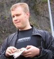
Vanguardist thepiguy founded our occupation of Mouseover Day Basecamp, the nearest land point to the actual coordinates, and when he has sufficiently recovered from the ordeal he may document that here. All we know so far is that when his parents left him there they asked concernedly, "Are you sure your friends will be able to find you here?" It was a very long beach with a number of different access points and impassable rock barriers. Pi assured them that the algorithm would work.
The initial plan had only gone as far as the ferry, because we'd assumed we'd be all together during the crossing to plot the next phase of the expedition. Absent that opportunity, we resorted to plain old-fashioned geohashing. Robyn followed Wade's unfailing (i.e. it never fails to be hilarious) GPS receiver onto Highway 101, off highway 101 through a baffling tour of Gibsons area back roads and then back onto Highway 101. Reaching Sechelt it asked for two turns into successive non-existent streets, so we turned onto a different street, cut down an alley, and ended up in a splendid free parking spot only 800 metres from the geohash. While Wade and Robyn iced the cake on a picnic table, Elbie went off in search of the best spot on the beach from which to access the geohash.
In a gratuitous display of technology, Wade used his new phone to take a picture of the house (and bears) next to which we were parked and send it to Xore. This is gratuitous in that (a) the address would have been sufficient and (b) it was completely unnecessary for Xore to know where Robyn's car was. But it was cool.
Wade and Robyn then followed the beach and Robyn's GPS towards the geohash, and just the way the algorithm is supposed to work, the nearest spot on the beach to the geohash was occupied by geohashers. It didn't take long (possibly because they hadn't made a scenic tour of Gibsons nor stopped to ice a cake) for Rhonda, Xore and Yangman to join the party, followed by Juventas, Arbron and Ben. It could only have been cooler if some geohashers had arrived out of the sea in full SCUBA gear. OMG! Why didn't we think of that earlier?!
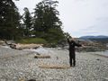
No SCUBA gear was present, but we did have five boats (three kayaks and two dingies, all nominally inflatables). The beach was very rocky, but there was a large formation of solid rock forming both a windbreak and a number of comfortable places to sit and place our gear. We marked the spot with an xkcd flag and our presence, and while there were other people out walking that day, we pretty much had an entire glorious section of the beach to ourselves.
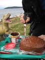
Next year we'll make the cake a little further ahead
Photo similar to that transmitted to Xore
Wade prepares a piece of driftwood to serve as the xkcd flagpole
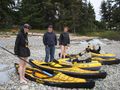
Official Navy of the Vancouver Graticule


Striking Out for the Geohash

The point of a basecamp is to form the base for further expedition, and our true destination was 650 metres south into the sea. It was a trivial distance compared to some kayak adventures we have had, and given our strength of numbers and experience we were fully prepared to reach it.
Boat#1: thepiguy
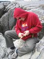
As pi had been there about two hours longer than anyone else, he was eager to make an attempt and launched his dingy before all the kayaks were unloaded and set up. The wind looked seemed to be blowing almost directly towards the beach from the geohash, and we watched from the beach with grave concern as he launched into the waves and rapidly drifted downwind, struggling with paddle configuration and really stupid oarlocks. "How far out is he?" asked Juventas, for whom this was the first waterhash, after about twenty minutes.
"About 30 metres," someone explained.
"So that means he has to go twenty times that far?"
This report will wait, as did the geohashers on the beach, for the results of pi's expedition by his own efforts.

Flotilla #2: Robyn, Rhonda, Xore and Juventas
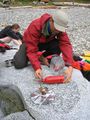
Next the kayakers prepared their craft for an assault on the coordinates. Robyn laid out her boat on the flat part of the rocks and inflated the three sections tubes. Rhonda sent Xore back to the car for something that was missing, then began to assemble her boat. Xore declared, "I'm here and my boat is here. Anyone who wants to borrow my boat can go ahead." Juventas took him up on the offer and began to follow the inflatable kayak assembly instructions.
Robyn began to load snacks into her kayak and then paused. "I hear hissing." Hissing and inflatable kayaks, the group agreed, were bad. Either there is a snake in the boat or it is leaking. Either way, you should not put your legs inside. After some disassembly Robyn identified the source of the hissing as a small crack next to one of the seams in a side tube.
Rhonda nodded knowledgeably. "They're hard to patch there. That's the same place I had one." Rhonda explained the proper technique of cutting down the ridge on the seam, then putting patches on each side of it, and then apply a final bridging patch, in order to cover the hole without getting an air gap. Robyn hadn't brought a patch kit, so Rhonda sent Xore to the car for hers.
About the time Robyn was finishing her first patch, Rhonda heard hissing. At the same seam. Rhonda's patching technique had held up for a number of expeditions, but chose the most ironic time to give out. Not the worst time. That might be 650 metres out to sea. Rhonda started patching hers. After twenty minutes or so, Robyn tested her patch work by inflating the tube. There was less hissing, but still hissing. Rhonda made two patching attempts, both of which ended in hissing.
The boat that Juventas inflated did not hiss, but his enthusiasm may have subsided slightly after that.
Boat#5: Challenger
Picnicking & General Revelry
Aside from the entertainment afforded by multiple people failing to reach the geohash by boat, basecamp festivities included samosas, cake, pie, Nibs, German gummi bears, hot chocolate, s'mores, and a selection of large, small, white and multicoloured marshmallows. The pie was provided by thepieguy as a bribe in exchange for a ride home from Geohashing Day, because he wasn't sure if the buses were still running. We also posed for a recreation of a [famous photograph]. We didn't have enough people to do The Last Supper.
It was too windy for board games, so we saved them for the ferry home.
"Xore, could you please go to the car and get ..."
Pi improvised a camera monopod for a group photo showing everyone
Yangman made everyone hot chocolate


The Trip Home
It didn't take as long as one might expect to pack all the gear from the beach back up to the cars, sweeping for any garbage escaped from our own or previous beach-using parties. Wade hopes they found a teaspoon that he remembers spotting in a tidepool.
On the ferry back to Horseshoe Bay, most of the group played a rousing game of "Xore and Elbie argue about the rules to a Ticket to Ride." Moments after they had finally agreed on a compromise version of the "Germany travelling house rules," an announcement summoned us back to the cars to prepare for disembarkation.
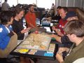
A Ticket to Ride: Europe Edition

Sleeping with the dinosaur


Elbie requested that Wade and Robyn not use the talking GPS on the trip back to UBC. I wonder why.
Quotes
While driving out to UBC to pick up Elbie, Robyn commented "We haven't had any hashpoints in the endowment lands. The Algorithm really should give us a point here." Thinking of how to encourage The Algorithm to give us pleasing hashpoints, Wade replied "Does one make sacrifices to The Algorithm? I mean, other than getting up at 6:25 in the morning after going to bed at 1:30 after a 9 km hike the night before?"
"It was everything I hoped and dreamed it would be." --- Xore, describing the sticky buns at the ferry terminal.
"Geohashing: where the logic stops." --- Unknown, for obvious reasons.
"Geohashing: where the logic stops, throws it into reverse, and backs over a cliff." --- Xore, responding to the above quote.
Tracklog
http://www.everytrail.com/view_trip.php?trip_id=631206
Achievements
Vancouver & Guests earned the 2010 Mouse Over Day achievement
|