Difference between revisions of "2010-08-07 -36 174"
imported>Greenslime (Created page with '{{subst:Expedition |lat = -36 |lon = 174 |date = 2010-08-07 }}') |
imported>FippeBot m (Location) |
||
| (15 intermediate revisions by 2 users not shown) | |||
| Line 1: | Line 1: | ||
| − | |||
<!-- If you did not specify these parameters in the template, please substitute appropriate things for IMAGE, LAT, LON, and DATE (YYYY-MM-DD format) | <!-- If you did not specify these parameters in the template, please substitute appropriate things for IMAGE, LAT, LON, and DATE (YYYY-MM-DD format) | ||
| Line 15: | Line 14: | ||
}} | }} | ||
| − | + | ||
__NOTOC__ | __NOTOC__ | ||
== Location == | == Location == | ||
| − | + | On the edge of Chamberland Park Golf Course, Point Chevalier, Auckland | |
== Participants == | == Participants == | ||
| − | + | *[[User:Greenslime|Greenslime]] | |
| + | |||
== Plans == | == Plans == | ||
| − | + | Now I honestly truly contemplated doing the whole public transport thing, but its just way too hard in Auckland. So im going to hop in my car and drive to the hash! | |
| + | |||
| + | *[[User:JimmyNZ|JimmyNZ]] thought about it, but unfortunately, as he is currently geographically incapacitated, wouldn't be joining | ||
| + | |||
== Expedition == | == Expedition == | ||
| − | + | It all started by getting rudely awoken by a text from [[User:JimmyNZ|JimmyNZ]] raving on about how I was going to get some Hash action, (and perhaps consecutive hash action) and well, that he was not... Google maps showed it to be right on the edge of a golf course. I considered public transport - too hard basket, then seriously considered Tron achievement, bypassing the fact that it was down a dead end road, I planned to park my car at the top, walk down, and then nip back through the golf course in a circular sort of manner. Even planned the motorway route home through Upper Harbour Highway. Of course, the large fence I discovered on arrival perhaps indicated that the golf course facilities were for more exclusive clientèle and not rouges off the street, like me. | |
| + | |||
| + | Peering through the fence, the hash was ever so close (see rubbish skip visible in satellite image). Running parallel to the golf course was a cycle way, so I wandered down it, hoping to get some token photos of some funky stuff, of course, examining the fence line as I went, and I found this wee inhomogeneity in the fence (see photo). So, I know it was naughty, and I could get in trouble, but I vaulted through, wandered back around to the hash point, looking like I was supposed to be there, although minus a golf club (disguise: mental note for next time). Now there was an awful lot of golfing activity going on for a very rainy Auckland day. No wonder they get struck by lightening these golfers. Anyway, took the photos near the skip, did a bit of token geo-trashing to relieve my guilt for being there, and wandered back from where I came from. | ||
== Tracklog == | == Tracklog == | ||
| − | + | I even took an early exit off the SH16 motorway in order to fulfil the Tron achievement. Oh well, next time. SH1 to SH16, off at St Lukes, onto Asquith, New North, Carrington. Took the Upper Harbour Highway home. | |
== Photos == | == Photos == | ||
| − | |||
| − | |||
| − | |||
<gallery perrow="5"> | <gallery perrow="5"> | ||
| + | Image:2010-08-07 -36 174 gmap.JPG|Satellite image of the hash | ||
| + | Image:2010-08-07 -36 174 The Fence at Novar Place.jpg|The un-planned-for fence at Novar Place | ||
| + | Image:2010-08-07 -36 174 Hash point behind the fence.jpg|The hash must be all of 5m away... | ||
| + | Image:2010-08-07 -36 174 The hole in the fence.jpg|So, um, a little wander round found this... | ||
| + | Image:2010-08-07 -36 174 at the hash point.jpg|at the hash point, inside the fence, looking dubious | ||
| + | Image:2010-08-07 -36 174 15th tee golfers.jpg|View of the 15th tee from the hashpoint. | ||
| + | Image:2010-08-07 -36 174 Geotrash.jpg|Geotrash and another conveniently positioned Auckland City Council rubbish bin. | ||
| + | |||
</gallery> | </gallery> | ||
== Achievements == | == Achievements == | ||
{{#vardefine:ribbonwidth|800px}} | {{#vardefine:ribbonwidth|800px}} | ||
| − | |||
| + | {{Geotrash | ||
| + | | latitude = -36 | ||
| + | | longitude = 174 | ||
| + | | date = 2010-08-07 | ||
| + | | name = [[User:Greenslime|Greenslime]] | ||
| + | | image = 2010-08-07_-36_174_Geotrash.jpg | ||
| + | }} | ||
| − | + | {{No_batteries_geohash | |
| − | + | | latitude = -36 | |
| − | [[ | + | | longitude = 174 |
| − | + | | date = 2010-08-07 | |
| − | + | | name = [[User:Greenslime|Greenslime]] | |
| − | + | | image = 2010-08-07_-36_174_The_Fence_at_Novar_Place.jpg | |
| − | + | }} | |
| − | |||
| − | |||
[[Category:Expeditions]] | [[Category:Expeditions]] | ||
| − | |||
[[Category:Expeditions with photos]] | [[Category:Expeditions with photos]] | ||
| − | |||
[[Category:Expedition without GPS]] | [[Category:Expedition without GPS]] | ||
| − | |||
| − | |||
| − | |||
[[Category:Coordinates reached]] | [[Category:Coordinates reached]] | ||
| − | + | [[Category:Golf course]] | |
| − | + | {{location|NZ|AUK}} | |
| − | |||
| − | |||
| − | |||
| − | |||
| − | |||
| − | |||
| − | [[Category: | ||
| − | |||
Latest revision as of 03:09, 9 August 2019
| Sat 7 Aug 2010 in -36,174: -36.8714800, 174.7146075 geohashing.info google osm bing/os kml crox |
Location
On the edge of Chamberland Park Golf Course, Point Chevalier, Auckland
Participants
Plans
Now I honestly truly contemplated doing the whole public transport thing, but its just way too hard in Auckland. So im going to hop in my car and drive to the hash!
- JimmyNZ thought about it, but unfortunately, as he is currently geographically incapacitated, wouldn't be joining
Expedition
It all started by getting rudely awoken by a text from JimmyNZ raving on about how I was going to get some Hash action, (and perhaps consecutive hash action) and well, that he was not... Google maps showed it to be right on the edge of a golf course. I considered public transport - too hard basket, then seriously considered Tron achievement, bypassing the fact that it was down a dead end road, I planned to park my car at the top, walk down, and then nip back through the golf course in a circular sort of manner. Even planned the motorway route home through Upper Harbour Highway. Of course, the large fence I discovered on arrival perhaps indicated that the golf course facilities were for more exclusive clientèle and not rouges off the street, like me.
Peering through the fence, the hash was ever so close (see rubbish skip visible in satellite image). Running parallel to the golf course was a cycle way, so I wandered down it, hoping to get some token photos of some funky stuff, of course, examining the fence line as I went, and I found this wee inhomogeneity in the fence (see photo). So, I know it was naughty, and I could get in trouble, but I vaulted through, wandered back around to the hash point, looking like I was supposed to be there, although minus a golf club (disguise: mental note for next time). Now there was an awful lot of golfing activity going on for a very rainy Auckland day. No wonder they get struck by lightening these golfers. Anyway, took the photos near the skip, did a bit of token geo-trashing to relieve my guilt for being there, and wandered back from where I came from.
Tracklog
I even took an early exit off the SH16 motorway in order to fulfil the Tron achievement. Oh well, next time. SH1 to SH16, off at St Lukes, onto Asquith, New North, Carrington. Took the Upper Harbour Highway home.
Photos
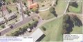
Satellite image of the hash
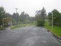
The un-planned-for fence at Novar Place
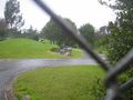
The hash must be all of 5m away...
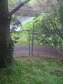
So, um, a little wander round found this...

at the hash point, inside the fence, looking dubious
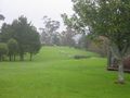
View of the 15th tee from the hashpoint.
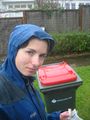
Geotrash and another conveniently positioned Auckland City Council rubbish bin.


Achievements
Greenslime earned the GeoTrash Geohash Achievement
|
Greenslime earned the No Batteries Geohash Achievement
|